Vyšehoří
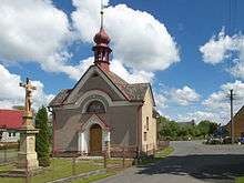
Baroque chapel of John of Nepomuk in Vyšehoří
| Vyšehoří | |
|---|---|
| Municipality | |
 Vyšehoří | |
| Coordinates: 49°56′19″N 16°51′49″E / 49.93861°N 16.86361°ECoordinates: 49°56′19″N 16°51′49″E / 49.93861°N 16.86361°E | |
| Country |
|
| Region | Olomouc |
| District | Šumperk |
| Area | |
| • Total | 3.47 km2 (1.34 sq mi) |
| Elevation | 324 m (1,063 ft) |
| Population (2006) | |
| • Total | 200 |
| • Density | 58/km2 (150/sq mi) |
| Postal code | 789 01 |
| Website | http://www.vysehori.wz.cz |
Vyšehoří (German: Wischehor) is a village and municipality (obec) in Šumperk District in the Olomouc Region of the Czech Republic.
The municipality covers an area of 3.47 square kilometres (1.34 sq mi), and has a population of 200 (as at 3 July 2006).
Vyšehoří lies approximately 9 kilometres (6 mi) west of Šumperk, 48 km (30 mi) north-west of Olomouc, and 176 km (109 mi) east of Prague.
The name is derived from its locality „higher in the mountains“ (Vyše - higher, hoří - mountains) as it is situated in Drozdovská vrchovina highlands. The very first note about the village comes from 1397 when Vyšehoří was transferred from Ruda nad Moravou manor to Zábřeh manor. The village was part of Zábřeh manor to the fall of the feudal system in 1848.
References
| Wikimedia Commons has media related to Vyšehoří. |
This article is issued from Wikipedia - version of the 7/2/2016. The text is available under the Creative Commons Attribution/Share Alike but additional terms may apply for the media files.