Walling, Tennessee
| Walling, Tennessee | |
|---|---|
| Unincorporated community | |
|
Post office in Walling | |
 Walling, Tennessee  Walling, Tennessee | |
| Coordinates: 35°48′29″N 85°35′58″W / 35.80806°N 85.59944°WCoordinates: 35°48′29″N 85°35′58″W / 35.80806°N 85.59944°W | |
| Country | United States |
| State | Tennessee |
| County | White |
| Elevation | 886 ft (270 m) |
| Time zone | Central (CST) (UTC-6) |
| • Summer (DST) | CDT (UTC-5) |
| ZIP code | 38587 |
| Area code(s) | 931 |
| GNIS feature ID | 1304347[1] |
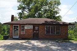
Walling is an unincorporated community in White County, Tennessee, United States. It lies along the Caney Fork southwest of Doyle, and east of Rock Island State Park. Tennessee State Route 136 passes through the community. Walling has a post office with ZIP code 38587.[2]
The community is likely named for a family of early settlers.[3]
References
- ↑ "US Board on Geographic Names". United States Geological Survey. 2007-10-25. Retrieved 2008-01-31.
- ↑ ZIP Code Lookup
- ↑ Larry Miller, Tennessee Place Names (Indiana University Press, 2001), p. 215.
External links
Municipalities and communities of White County, Tennessee, United States | ||
|---|---|---|
| City | ||
| Town | ||
| Unincorporated communities | ||
This article is issued from Wikipedia - version of the 7/31/2016. The text is available under the Creative Commons Attribution/Share Alike but additional terms may apply for the media files.