Wallumbilla, Queensland
| Wallumbilla Queensland | |||||||||||||
|---|---|---|---|---|---|---|---|---|---|---|---|---|---|
 Newsagency and general store | |||||||||||||
 Wallumbilla | |||||||||||||
| Coordinates | 26°35′0″S 149°11′0″E / 26.58333°S 149.18333°ECoordinates: 26°35′0″S 149°11′0″E / 26.58333°S 149.18333°E | ||||||||||||
| Population | 262 (2011 census)[1] | ||||||||||||
| Postcode(s) | 4428 | ||||||||||||
| Location | |||||||||||||
| LGA(s) | Maranoa Region | ||||||||||||
| State electorate(s) | Warrego | ||||||||||||
| Federal Division(s) | Maranoa | ||||||||||||
| |||||||||||||
Wallumbilla is a town and locality in the Maranoa Region, Queensland, Australia.[2][3] In the 2011 census, Wallumbilla had a population of 262 people.[1]
Geography
Wallumbilla is situated five hours by road west from Brisbane, just east of Roma in South West Queensland.
To the north of Wallumbilla the Great Dividing Range (in this region no more than a bumpy watershed) passes roughly ESE to NNW. The town is sandwiched between Wallumbilla & Middle Creeks as they flow south toward the Condamine/Balonne River.
History
The name Wallumbilla was the name of a pastoral run leased by Charles Coxen, The name is presumed to come from the indigenous Mandandanji language and reportedly means wallu=plenty and billa=jew fish.[2][3]
At the 2006 census, Wallumbilla had a population of 285.[4]

Amenities
Wallumbilla's Calico Cottage, open seven days a week, is the town's Visitor Information Centre. As well as this, Calico Cottage sells locally produced arts and crafts along with refreshments.
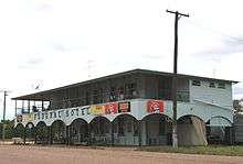
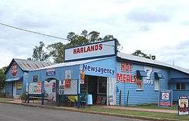
The town also contains three churches, as well as a Masonic Hall. Other amenities include a hotel/pub, a news agency, and a petrol station.
Wallambilla has a public library, heritage complex and visitor information centre.
Education
While the town proper has under 300 residents, the local school (Wallumbilla State School) has over 100 enrolled students. Most of these students hail from properties surrounding town, as well as the high school students from neighbouring town Yuleba.
Economy
Traditionally Wallumbilla's main industries were dairy and beef cattle, now the main industries are cropping and beef cattle. The main crops include sorghum and wheat.
Locals believe that if not for the discovery of gas at nearby hub Roma, Wallumbilla would have flourished into a similar hub, as the discovery of gas in 1908 near Roma preluded the Wallumbilla cattle sale yards (a thriving business according to local history) to move up to Roma, accentuating its growth.
A major gas hub is in preparation for Wallumbilla, planned to start operation in 2014.[5]
Heritage listings
Wallumbilla has a number of heritage-listed sites, including:
- George Street: Nostalgic Queen's Theatre[6]
References
- 1 2 Australian Bureau of Statistics (31 October 2012). "Wallumbilla (SSC)". 2011 Census QuickStats. Retrieved 17 August 2016.
- 1 2 "Wallumbilla - town (entry 36362)". Queensland Place Names. Queensland Government. Retrieved 18 August 2016.
- 1 2 "Wallumbilla - locality (entry 47462)". Queensland Place Names. Queensland Government. Retrieved 18 August 2016.
- ↑ Australian Bureau of Statistics (25 October 2007). "Wallumbilla (L) (Urban Centre/Locality)". 2006 Census QuickStats. Retrieved 29 November 2008.
- ↑ "Gas Supply Hub". Australian Energy Market Operator. Retrieved 18 February 2014.
- ↑ "Nostalgic Queen's Theatre (entry 602378)". Queensland Heritage Register. Queensland Heritage Council. Retrieved 11 July 2013.
External links
| Wikimedia Commons has media related to Wallumbilla, Queensland. |
- Maranoa Online A portal servicing the Maranoa - a region encompassing Wallumbilla
- University of Queensland: Queensland Places: Wallumbilla