Waterloo, New York (town)
| Waterloo, New York | |
|---|---|
| Town | |
 Waterloo, New York Location within the state of New York | |
| Coordinates: 42°55′16″N 76°51′42″W / 42.92111°N 76.86167°WCoordinates: 42°55′16″N 76°51′42″W / 42.92111°N 76.86167°W | |
| Country | United States |
| State | New York |
| County | Seneca |
| Settled | 1800 |
| Established | March 26, 1829[1] |
| Government | |
| • Type | Town Council |
| • Supervisor | Gary Westfall |
| • Clerk | Sandra Ridley |
| • Court | Justice Christopher W. Folk |
| Area | |
| • Total | 21.9 sq mi (56.6 km2) |
| • Land | 21.7 sq mi (56.2 km2) |
| • Water | 0.2 sq mi (0.4 km2) |
| Elevation | 469 ft (143 m) |
| Population (2010) | |
| • Total | 7,642 |
| • Density | 352.2/sq mi (136.0/km2) |
| Time zone | Eastern (EST) (UTC-5) |
| • Summer (DST) | EDT (UTC-4) |
| ZIP code | 13165 |
| Area code(s) | 315 |
| FIPS code | 36-78564[2] |
| GNIS feature ID | 0979603[3] |
| Website | http://www.waterlootown.org/ |
Waterloo is a town in Seneca County, New York, United States. The population was 7,642 at the 2010 census. The town, as well as its major community, are named after Waterloo, Belgium.
There is also a village called Waterloo, the primary county seat of Seneca County. The Town of Waterloo is situated on the west border of the county, east of Geneva, New York.
History
The area was the domain of the Seneca tribe and Cayuga tribe, who were visited in the 17th Century by Jesuit missionaries. The Sullivan Expedition passed through the area in 1779 to destroy the natives and their villages. After the war, the area was in the Central New York Military Tract, reserved for veterans.
The region was first settled around 1800. The town was formed from the Town of Junius in 1829.
Geography
According to the United States Census Bureau, the town has a total area of 21.8 square miles (56.5 km²), of which, 21.7 square miles (56.2 km²) is land and 0.2 square miles (0.4 km²) of it (0.78%) is water.
The west town line is the border of Ontario County, New York, and part of the south town line is Seneca Lake and the Seneca River/Cayuga-Seneca Canal.
The New York State Route 5/U.S. Route 20 concurrency is a major east-west highway in Waterloo. New York State Route 96 is a highway that turns southward at Waterloo village.
Demographics
| Historical population | |||
|---|---|---|---|
| Census | Pop. | %± | |
| 1830 | 1,837 | — | |
| 1840 | 3,036 | 65.3% | |
| 1850 | 3,795 | 25.0% | |
| 1860 | 4,594 | 21.1% | |
| 1870 | 4,469 | −2.7% | |
| 1880 | 4,309 | −3.6% | |
| 1890 | 4,681 | 8.6% | |
| 1900 | 4,659 | −0.5% | |
| 1910 | 4,429 | −4.9% | |
| 1920 | 4,287 | −3.2% | |
| 1930 | 4,569 | 6.6% | |
| 1940 | 4,730 | 3.5% | |
| 1950 | 5,524 | 16.8% | |
| 1960 | 6,891 | 24.7% | |
| 1970 | 7,763 | 12.7% | |
| 1980 | 7,811 | 0.6% | |
| 1990 | 7,765 | −0.6% | |
| 2000 | 7,866 | 1.3% | |
| 2010 | 7,642 | −2.8% | |
| Est. 2014 | 7,497 | [4] | −1.9% |
As of the census[2] of 2010, there were 7,642 people, 3,118 households, and 2,008 families residing in the town. The population density was 352.2 people per square mile (136.0/km²). The racial makeup of the town was 95.9% White, 1.5% Black or African American, 0.1% Native American, 0.3% Asian, 0.0% Pacific Islander, 0.4% from other races, and 1.8% from two or more races. Hispanic or Latino of any race were 2.5% of the population.
There were 3,118 households out of which 26.1% had children under the age of 18 living with them, 44.6% were married couples living together, 13.2% had a female householder with no husband present, and 35.6% were non-families. 28.8% of all households were made up of individuals and 11.9% had someone living alone who was 65 years of age or older. The average household size was 2.35 and the average family size was 2.83.
In the town the population was spread out with 23.5% under the age of 20, 5.7% from 20 to 24, 23.1% from 25 to 44, 29.5% from 45 to 64, and 18.2% who were 65 years of age or older. The median age was 43.3 years. For every 100 females there were 92.3 males. For every 100 females age 18 and over, there were 89.9 males.
The median income for a household in the town was $43,527, and the median income for a family was $53,625. Males had a median income of $39,743 versus $30,211 for females. The per capita income for the town was $23,147. About 7.6% of families and 10.2% of the population were below the poverty line, including 11.7% of those under age 18 and 4.6% of those age 65 or over.
Housing
There were 3,386 housing units at an average density of 156.0 per square mile (60.2/km²). 7.9% of housing units were vacant.
There were 3,118 occupied housing units in the town. 2,179 were owner-occupied units (69.9%), while 939 were renter-occupied (30.1%). The homeowner vacancy rate was 1.2% of total units. The rental unit vacancy rate was 10.1%.[2]
Schools in the Town of Waterloo
Public schools
- Skoi-Yase School is a public school that teaches Grades Pre-School to Grade 2. Its enrollment is about 420 students. The current principal is Liz Springer.[6]
- Lafayette School is a public school that teaches Grades 3-5. Its enrollment is about 344 students. The current principal is Sally Covert.[7]
- Main Street Multiage School is a public school that teaches Grades K-5. Its enrollment is about 117 students. The current principal is Wendy Doyle. The school was previously the Border City Elementary School until it moved to the former middle school building.
- Waterloo Middle School is a public school that teaches Grades 6-8. Its enrollment is about 546 students. The current principal is Michael Ferrara.[8]
- Waterloo High School - Grades 9-12. Its enrollment is about 608 students. The current principal is Jeramy Clingerman.[9]
Private schools
- Fayette Mennonite School is a private mennonite school that teaches Grades 1-8. Its enrollment is about 50 students. The current head teacher is Elizabeth Zimmerman.[10]
Until 2005, St. Mary's School operated as a private PreK-8 Roman Catholic school in Waterloo. After undergoing financial difficulties, it merged with St. Patrick's school in Seneca Falls, New York to form St. John Bosco School in 2005.
Communities and locations in the Town of Waterloo
- Border City – A hamlet near the west town line and Geneva. (also, see Serven below).
- Dobbins Corner – A hamlet at the west town line on County Road 112.
- East Geneva – A hamlet near the west town line on US-20.
- Packwood Corners – A hamlet on US-20, on the south town line.
- Parr Harbour – A location west of Waterloo village on US-20.
- Seneca Lake State Park – A state park in the southwest corner of the town.
- Seneca Meadows – New York State's largest active landfill
- Serven – A hamlet overlapping the portions of Border City northeast of the Northern Terminus of 96A. Extends between 96A and Packwood Road along Routes 5&20.
- Waterloo – The Village of Waterloo in on US-20 at the south town line, partly in the Town of Fayette.
Notable people
- Louise Blanchard Bethune, architect
- Tom Coughlin, former New York Giants and Jacksonville Jaguars' head coach.[11]
- Mike McLaughlin, NASCAR driver.
- Steven Stanzak, a New York University student famous for living in the school's library from September 2003 to April 2004.
- Charles E. Stuart, U.S. Representative and Senator from Michigan.
- George Bradshaw Kelly, U.S. Representative for New York's 38th congressional district, from 1937 to 1939.
References
- ↑ New York Roots - The History of New York State by Dr. James Sullivan (Book VII, Chapter IV - Seneca County), Retrieved Jun. 2, 2015.
- 1 2 3 "American FactFinder". United States Census Bureau. Retrieved 2015-06-02.
- ↑ "US Board on Geographic Names". United States Geological Survey. 1995-09-01. Retrieved 2008-06-02.
- ↑ "Annual Estimates of the Resident Population for Incorporated Places: April 1, 2010 to July 1, 2014". Retrieved June 4, 2015.
- ↑ "Census of Population and Housing". Census.gov. Retrieved June 4, 2015.
- ↑ NYS Admin Listing
- ↑ NYS Admin Listing
- ↑ NYS Admin Listing
- ↑ NYS Admin Listing
- ↑ NYS Admin Listing
- ↑ http://www.pro-football-reference.com/coaches/CougTo0.htm
External links
 |
Lyons | Junius | | |
| Geneva | |
Seneca Falls | ||
| ||||
| | ||||
| Sampson State Park | Ovid | Cayuga Lake State Park |
Municipalities and communities of Seneca County, New York, United States | ||
|---|---|---|
| City | 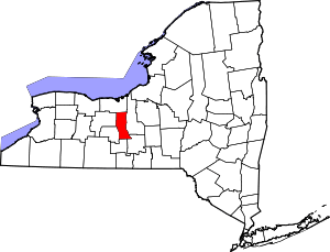 | |
| Towns | ||
| Villages | ||
| CDP | ||
| Hamlets |
| |
| Footnotes | ‡This populated place also has portions in an adjacent county or counties | |