Watts, Oklahoma
| Watts, Oklahoma | |
|---|---|
| Town | |
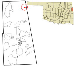 Location within Adair County and the state of Oklahoma | |
| Coordinates: 36°6′28″N 94°34′17″W / 36.10778°N 94.57139°WCoordinates: 36°6′28″N 94°34′17″W / 36.10778°N 94.57139°W | |
| Country | United States |
| State | Oklahoma |
| County | Adair |
| Area | |
| • Total | 0.4 sq mi (1.0 km2) |
| • Land | 0.4 sq mi (1.0 km2) |
| • Water | 0.0 sq mi (0.0 km2) |
| Elevation | 981 ft (299 m) |
| Population (2010) | |
| • Total | 324 |
| • Density | 810/sq mi (324/km2) |
| Time zone | Central (CST) (UTC-6) |
| • Summer (DST) | CDT (UTC-5) |
| ZIP code | 74964 |
| Area code(s) | 539/918 |
| FIPS code | 40-79100[1] |
| GNIS feature ID | 1099434[2] |
Watts is a town in northern Adair County, Oklahoma, United States. It was named for John Watts, also known as Young Tassel, a Chickamauga Cherokee chief.[3] The population was 324 at the 2010 census, an increase of 2.5 percent from 316 at the 2000 census.[4]
Geography
Watts is located at 36°6′28″N 94°34′17″W / 36.10778°N 94.57139°W (36.107896, -94.571389).[5]
According to the United States Census Bureau, the town has a total area of 0.4 square miles (1.0 km2), all of it land.
Watts is located on U.S. Highway 59 9 miles (14 km) north of Westville.[6]
Demographics
| Historical population | |||
|---|---|---|---|
| Census | Pop. | %± | |
| 1920 | 396 | — | |
| 1930 | 353 | −10.9% | |
| 1940 | 307 | −13.0% | |
| 1950 | 267 | −13.0% | |
| 1960 | 268 | 0.4% | |
| 1970 | 326 | 21.6% | |
| 1980 | 316 | −3.1% | |
| 1990 | 303 | −4.1% | |
| 2000 | 316 | 4.3% | |
| 2010 | 324 | 2.5% | |
| Est. 2015 | 311 | [7] | −4.0% |
As of the census[1] of 2000, there are 316 people, 103 households, and 73 families residing in the town. The population density was 861.0 people per square mile (329.8/km²). There were 120 housing units at an average density of 326.9 per square mile (125.2/km²). The racial makeup of the town was 66.14% White, 0.32% African American, 24.68% Native American, 0.63% Asian, 1.58% from other races, and 6.65% from two or more races. 3.16% of the population are Hispanic or Latino of any race.
There are 103 households out of which 36.9% have children under the age of 18 living with them, 58.3% are married couples living together, 9.7% have a female householder with no husband present, and 28.2% are non-families. 27.2% of all households are made up of individuals and 14.6% have someone living alone who is 65 years of age or older. The average household size is 2.76 and the average family size is 3.35.
In the town the population was 27.2% under the age of 18, 10.4% from 18 to 24, 28.5% from 25 to 44, 21.5% from 45 to 64, and 12.3% who are 65 years of age or older. The median age is 35 years. For every 100 females there are 93.9 males. For every 100 females age 18 and over, there are 94.9 males.
The median income for a household in the town was $26,417, and the median income for a family was $27,250. Males had a median income of $25,543 versus $18,393 for females. The per capita income for the town was $9,356. 19.7% of the population and 9.6% of families were below the poverty line. Out of the total population, 21.6% of those under the age of 18 and none of those 65 and older were living below the poverty line.
References
- 1 2 "American FactFinder". United States Census Bureau. Retrieved 2008-01-31.
- ↑ "US Board on Geographic Names". United States Geological Survey. 2007-10-25. Retrieved 2008-01-31.
- ↑ Hagan, Phyllis. Encyclopedia of Oklahoma History and Culture. "Watts." Retrieved September 11, 2012.
- ↑ CensusViewer:Watts, Oklahoma Population
- ↑ "US Gazetteer files: 2010, 2000, and 1990". United States Census Bureau. 2011-02-12. Retrieved 2011-04-23.
- ↑ Official State Map (Map) (2008 ed.). Oklahoma Department of Transportation.
- ↑ "Annual Estimates of the Resident Population for Incorporated Places: April 1, 2010 to July 1, 2015". Retrieved July 2, 2016.
- ↑ "Census of Population and Housing". Census.gov. Retrieved June 4, 2015.
Municipalities and communities of Adair County, Oklahoma, United States | ||
|---|---|---|
| City | 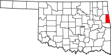 | |
| Towns | ||
| CDPs | ||
| Other unincorporated communities | ||