Watts Mill Bridge
| Watts Mill Bridge | |
| Bridge in South Beaver Township | |
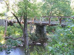 Watts Mill Bridge in September 2008 | |
| Country | United States |
|---|---|
| State | Pennsylvania |
| County | Beaver |
| Township | South Beaver |
| Road | Watts Mill Road (single lane) |
| Crosses | Little Beaver Creek |
| Coordinates | 40°47′26″N 80°29′38″W / 40.79056°N 80.49389°WCoordinates: 40°47′26″N 80°29′38″W / 40.79056°N 80.49389°W |
| Length | 109 ft (33 m) [1] |
| - Mainspan | 48 ft (15 m) [2] |
| Width | 12.5 ft (4 m) [1] |
| Builder | West Penn Bridge Company |
| Design | Pin-connected Pratt pony truss bridge |
| Material | Steel |
| Built | 1878 |
| Owned and Maintained by | PennDOT |
| NBI Number | 044009006000000 |
| Load | 14.5 t (16.0 short tons) [1] |
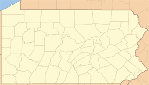 Location of the Watts Mill Bridge in Pennsylvania | |
|
Bridge in South Beaver Township | |
| Area | less than one acre |
|---|---|
| Architect | West Penn Bridge Co. |
| MPS | Highway Bridges Owned by the Commonwealth of Pennsylvania, Department of Transportation TR |
| NRHP Reference # | 88000868[3] |
| Added to NRHP | June 22, 1988 |
The Watts Mill Bridge is a pin-connected Pratt pony truss bridge located over the Little Beaver Creek in Cannelton, Pennsylvania, United States.
The bridge was constructed in 1878 by the West Penn Bridge Company, based in nearby Beaver Falls PA. The bridge is located in a valley approximately a quarter mile north of the North Country Trail. The bridge was listed on the National Register of Historic Places in 1988. When the bridge was given this designation by the NRHP, it was simply known as the Bridge in South Beaver Township. It is the only bridge in Beaver County on the National Register for itself,[3] although the Bridgewater-Rochester Bridge over the Beaver River is part of the Bridgewater Historic District in Bridgewater to the south.[4]
In 2004, the bridge, which was becoming rusty and falling into disrepair and considered for demolition by PennDOT, was placed on the Top Ten Best Historic Preservation Opportunities in the Pittsburgh Area by the Young Preservationists Association of Pittsburgh. No major renovations have been done to the bridge.
See also
- List of bridges on the National Register of Historic Places in Pennsylvania
- National Register of Historic Places listings in Beaver County, Pennsylvania
References
- 1 2 3 Federal Highway Administration National Bridge Inventory (2009). "Place Name: South Beaver (Township of), Pennsylvania NBI Structure Number: 044009006000000; Facility Carried: Watts Mill RD; Feature Intersected: Little Beaver Creek". Nationalbridges.com (Alexander Svirsky). Retrieved April 9, 2009. Note: this is a formatted scrape of the 2006 official website, which can be found here for Pennsylvania: "PA06.txt". Federal Highway Administration. 2006. Retrieved June 7, 2008.
- ↑ PennDOT (October 1, 1982). "Nomination Form" (PDF). National Register of Historic Places. Retrieved April 9, 2009.
- 1 2 National Park Service (2010-07-09). "National Register Information System". National Register of Historic Places. National Park Service.
- ↑ Buerkle, John, Jr., and Mike Eversmeyer. National Register of Historic Places Inventory/Nomination: Bridgewater Historic District. National Park Service, 1996-03-03, 5.
| Topics |   | |
|---|---|---|
| Lists by county |
| |
| Lists by city | ||
| Other lists | ||
| ||