Wheatland, Montana
| Wheatland, Montana | |
|---|---|
| Census-designated place | |
 Wheatland | |
| Coordinates: 45°54′12″N 111°36′0″W / 45.90333°N 111.60000°WCoordinates: 45°54′12″N 111°36′0″W / 45.90333°N 111.60000°W | |
| Country | United States |
| State | Montana |
| County | Broadwater |
| Area | |
| • Total | 76.2 sq mi (197.3 km2) |
| • Land | 75.6 sq mi (195.9 km2) |
| • Water | 0.6 sq mi (1.5 km2) |
| Elevation | 4,175 ft (1,273 m) |
| Population (2010) | |
| • Total | 568 |
| • Density | 8/sq mi (2.9/km2) |
| Time zone | Mountain (MST) (UTC-7) |
| • Summer (DST) | MDT (UTC-6) |
| Area code(s) | 406 |
| FIPS code | 30-79695 |
| GNIS feature ID | 2583865 |
Wheatland is a census-designated place (CDP) in Broadwater County, Montana, United States. The population was 568 at the 2010 census.[1]
Geography
Wheatland occupies a large area in the southern end of Broadwater County. U.S. Route 287 runs north-south through the CDP, intersecting Interstate 90 at that highway's Exit 274. Montana Highway 2 leads east across the Jefferson River to the city of Three Forks in Gallatin County.
According to the United States Census Bureau, the Wheatland CDP has a total area of 76.2 square miles (197.3 km2), of which 75.6 square miles (195.9 km2) is land and 0.58 square miles (1.5 km2), or 0.74%, is water.[1]
References
- 1 2 "Geographic Identifiers: 2010 Demographic Profile Data (G001): Wheatland CDP, Montana". U.S. Census Bureau, American Factfinder. Retrieved June 26, 2013.
Municipalities and communities of Broadwater County, Montana, United States | ||
|---|---|---|
| City | 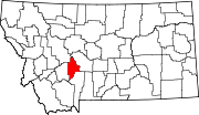 | |
| CDPs | ||
| Unincorporated community | ||
This article is issued from Wikipedia - version of the 12/7/2013. The text is available under the Creative Commons Attribution/Share Alike but additional terms may apply for the media files.