Whitesboro, Alabama
| Whitesboro, Alabama | |
|---|---|
| Census-designated place | |
 Whitesboro | |
| Coordinates: 34°09′48″N 86°04′10″W / 34.16333°N 86.06944°WCoordinates: 34°09′48″N 86°04′10″W / 34.16333°N 86.06944°W | |
| Country | United States |
| State | Alabama |
| County | Etowah |
| Area[1] | |
| • Total | 17.506 sq mi (45.34 km2) |
| • Land | 17.484 sq mi (45.28 km2) |
| • Water | 0.022 sq mi (0.06 km2) |
| Elevation | 1,063 ft (324 m) |
| Population (2010)[2] | |
| • Total | 2,138 |
| • Density | 120/sq mi (47/km2) |
| Time zone | Central (CST) (UTC-6) |
| • Summer (DST) | CDT (UTC-5) |
| Area code(s) | 256 & 938 |
| GNIS feature ID | 128915[3] |
Whitesboro is a census-designated place and unincorporated community in Etowah County, Alabama, United States. Its population was 2,138 as of the 2010 census.[2]
References
- ↑ "US Gazetteer files: 2010, 2000, and 1990". United States Census Bureau. 2011-02-12. Retrieved 2011-04-23.
- 1 2 "American FactFinder". United States Census Bureau. Retrieved 2011-05-14.
- ↑ "Whitesboro". Geographic Names Information System. United States Geological Survey.
Municipalities and communities of Etowah County, Alabama, United States | ||
|---|---|---|
| Cities | 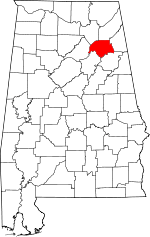 | |
| Towns | ||
| CDPs | ||
| Unincorporated communities | ||
| Footnotes | ‡This populated place also has portions in an adjacent county or counties | |
This article is issued from Wikipedia - version of the 1/22/2016. The text is available under the Creative Commons Attribution/Share Alike but additional terms may apply for the media files.