Williamstown, South Australia
- Not to be confused with the once eastern suburb of Mount Gambier, also called Williamstown.
| Williamstown South Australia | |||||||||||||
|---|---|---|---|---|---|---|---|---|---|---|---|---|---|
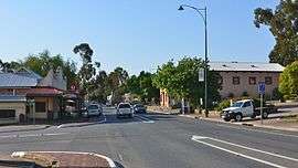 Queen Street, the main street of Williamstown | |||||||||||||
 Williamstown | |||||||||||||
| Coordinates | 34°40′0″S 138°53′0″E / 34.66667°S 138.88333°ECoordinates: 34°40′0″S 138°53′0″E / 34.66667°S 138.88333°E | ||||||||||||
| Population | 1,432 (2006 census)[1] | ||||||||||||
| Established | 1857 | ||||||||||||
| Postcode(s) | 5351 | ||||||||||||
| Elevation | 310 m (1,017 ft) | ||||||||||||
| Location |
51.7 km (32 mi) East of Adelaide via | ||||||||||||
| LGA(s) | Barossa Council | ||||||||||||
| State electorate(s) | Schubert | ||||||||||||
| Federal Division(s) | Mayo | ||||||||||||
| |||||||||||||
| |||||||||||||
Williamstown is a small South Australian village on the southern fringe of the Barossa Valley wine-growing region. It is 51 km north east of Adelaide and 16 km south-east of Gawler. Williamstown was originally known as Victoria Creek.[2] The village was laid out in 1858 by Lewis Johnston, or Johnstone, on land he purchased in 1857, and named for his son.[3]
The village has an elevation of 310m and an average rainfall of 680mm. It has a summer average temperature of 31 °C with temperatures often reaching mid 40's, and a winter average temperature of 15 °C, with nights dropping below freezing, which makes the region excellent for the cultivation of fruits, especially grapes in the lower riverine alluvial deposits.
Williamstown was essentially a farming area with sheep and cattle in the early days with fruit orchards, mixed farms and vines. The town also sustained a forestry and lumber industry from the earliest days with three sawmills. Today only a small family owned mill remains with the closure of the two larger mills by 1990. Many residents work in the wine / viticulture industry throughout the Barossa Valley.
In the Australian Federation Year a local hay barn found along Yettie Road (Yatta Creek Road) inhabited by ducks and pigeons was discovered to be the remains of the alleged oldest homestead in South Australia (circa 1821) which has been carefully restored to its former glory.
Springfield Homestead along Springton Road was originally the home of a local land baron pastoralist BJ McLaughlin who was a contemporary of the more famous Australian pastoral entrepreneurs and cattle barons. His great-great grandchildren still live at the historic Homestead. They still operate the fourth largest cattle station in Australia at Commonwealth Hill.
The nearby Barossa, Para Wirra and South Para Reservoirs were built in the early 1950s to help supply Adelaide with their demanding domestic water supplies. The Whispering Wall public attraction at the Barossa Reservoir is the colloquial name given to the curved dam retaining structure where nearby evidence of former small operation gold mining exists from the 1840s as evidenced by the local name of Kalamazoo Homestead. A handful of 'boutique' tourist gold mining operation were started around 1985 onwards near Sandy Creek and West of the reservoir aptly named the Barossa Goldfields. In recent decades numerous tourist accommodation and gastronomical ventures have been established to service the growing Barossa Valley wine tour industry, such as boutique businesses Linfield Road Wines / Cottage and Te-Aro Estate Wines.
Williamstown is considered to be a 'Southern gateway' town into the Barossa Valley itself and in recent years land releases and new family homes have brought a new lease of life to the sleepy little town which boasts one of the oldest public house hotels in South Australia dating from 1841and several original farm homesteads built by the first homesteaders from rough-cut slab timber. One excellent example of which can be found somewhere along Warren Road.
In the late summer of 1956 Williamstown was struck by a large earthquake of an estimated magnitude 4.1 that lasted for almost eight minutes and caused structural damaged to many of the stone structures and brick buildings in the area that can be seen to this day. It is reported that domestic wells and sweetwater springs in the area dried up for several weeks thereafter due to the many landslips and seismic movement below the surrounding Gawler Range and local hills.
In the springtime Williamstown is seen at its best with a carpet of green grass and wildflowers along the many creeks and thick woodlands covering the low rolling hills around the town dotted with large dairy pastures and vineyards. To the East and South Williamstown is skirted with Forestry Commission plantations open for public access in certain areas and large swathes of National Park and the Hales Conservation Park for hikers.
The Williamstown Oval is set in the welcome summer shade of a large wooded hill in a small valley ringed with a crystal clear cold water spring that feeds the stream that passes through the town. At the Oval there is a picnic area and small caravan park for visitors and transients alike overlooking the local Football Clubhouse and public swimming pool. In 1970 Williamstown had the happy pleasure of hosted one of the very last performances of the Barnum & Baily, Ringling Brothers Circus in the original Big Top at the Oval where their famous performing Elephants were enjoyed along with 'the world's smallest horse' at just over five hands high.
Williamstown is in the Barossa Council local government area, the state electoral district of Schubert and the federal Division of Mayo.
See also
- Barossa Reservoir and Whispering Wall
- Hale Conservation Park
- Para Wirra Conservation Park
- Hoffnungsthal, South Australia
- Williamstown Hotel
- Barossa District Football and Netball Club
- Linfield Road Wines
- Linfield Cottage
- Old Bakehouse Tavern
References
- ↑ Australian Bureau of Statistics (25 October 2007). Williamstown (Urban Centre/Locality). 2006 Census Quickstats. Retrieved on 2008-05-29
- ↑ Rodney Cockburn, Stewart Cockburn South Australia — What's in a Name? Axiom Publishing 1990 ISBN 0 9592519 1 X
- ↑ "Manning index of South Australian placenames". State Library of South Australia. Retrieved 1 April 2015.
External links
| Wikimedia Commons has media related to Williamstown, South Australia. |