Woodhead, Derbyshire
| Woodhead | |
 St James Church and Bleak House, Woodhead |
|
 Woodhead |
|
| OS grid reference | SE103000 |
|---|---|
| District | High Peak |
| Shire county | Derbyshire |
| Region | East Midlands |
| Country | England |
| Sovereign state | United Kingdom |
| Post town | GLOSSOP |
| Postcode district | SK13 |
| Police | Derbyshire |
| Fire | Derbyshire |
| Ambulance | North West |
| EU Parliament | East Midlands |
| UK Parliament | High Peak |
|
|
Coordinates: 53°29′49″N 1°50′46″W / 53.497°N 1.846°W
Woodhead is a small and scattered settlement at the head of the Longdendale valley in Derbyshire, England. It lies on the trans-Pennine A628 road connecting Greater Manchester and South Yorkshire, 19 miles (31 km) miles from Manchester and 18 miles (29 km) from Barnsley. It is close to the River Etherow and the Trans Pennine Trail. Like nearby Tintwistle and Crowden, it was in the county of Cheshire before local government re-organisation in 1974.[1]
Woodhead is the location of the western portals of the Woodhead Tunnels, three former railway tunnels on the electrified Woodhead Line between Manchester and Sheffield. There was formerly a railway station and signal box at Woodhead. The Woodhead railway line closed in 1981; the trackbed between Woodhead and Hadfield now forms the Longdendale Trail. The platforms are still intact, although the track has been removed.
Among the remains in the graveyard of St James Church, a small 18th-century chapel, are the unmarked graves of navvies who died during the construction of the tunnels. Adjoining the church is Bleak House, a Grade-II-listed 19th-century dwelling.[2] Two miles to the east, the Lady Cross marks the highest point of the former packhorse road from Longdendale to Rotherham. Only its base and the bottom of the shaft survive.[3]
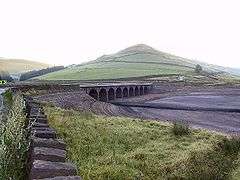
The hamlet gives its name to Woodhead Reservoir, the highest in the Longdendale Chain of reservoirs.[4]
On 6 July 2014, Stage 2 of the 2014 Tour de France from York to Sheffield, passed through the hamlet.
References
- ↑ "Gazetteer of Cheshire". Retrieved 7 November 2011.
- ↑ Historic England. "Bleak House and boundary wall and railings (Grade II) (1334810)". National Heritage List for England. Retrieved 25 March 2014.
- ↑ Sharpe, Neville T. (2002). Crosses of the Peak District. Landmark Collectors Library. ISBN 978-1843060444.
- ↑ Quayle, Tom (2006). Manchester's Water: The Reservoirs in the Hills. Stroud: Tempus. p. 8. ISBN 0-7524-3198-6.
| Wikimedia Commons has media related to Woodhead, Derbyshire. |