116th Street (Manhattan)
Coordinates: 40°48′05″N 73°56′53″W / 40.8013366°N 73.948073°W
 West 116th Street near Riverside Drive. | |
| Length | 1.73 mi (2.78 km) |
|---|---|
| Location | Manhattan |
| West end | Riverside Drive |
| Major junctions | Broadway at Columbia University |
| East end | FDR Drive |
116th Street runs from Riverside Drive, overlooking the Hudson River, to the East River, through the New York City borough of Manhattan. It traverses the neighborhoods of Morningside Heights, Harlem, and Spanish Harlem; the street is interrupted between Morningside Heights and Harlem by Morningside Park.
History
The street was designated by the Commissioners' Plan of 1811 that established the Manhattan street grid as one of 15 east-west streets that would be 100 feet (30 m) in width (while other streets were designated as 60 feet (18 m) in width).[1]
Description
West Side

The western entrance to 116th Street at Riverside Drive is flanked by a pair of white apartment buildings with curved facades, The Colosseum and The Paterno.
The New York Times has said that the "opposing curves, (form) a gateway as impressive as any publicly built arch or plaza in New York.[2] The unusual curves of the road are the result of an 1897 plan to make the land between Claremont Avenue and Riverside Drive into a public park in order to give veterans parades a large park adjacent to Grant's Tomb as a terminus. The street was redesigned so that a vehicle or a parade coming up Riverside Drive would swing onto 116th Street in a gracious curve, then immediately swing north onto Claremont Avenue following a second curve. The city never appropriated funds to buy the land, but the curves remain.[3] The top of The Paterno is capped with an architectural fancy masking a water tower in a shape that conjures up a section of Mansard roof, complete with dormer window. It is visible from the gates of Columbia University at Broadway and 116th Street.
The intersection of 116th Street and Broadway, is the location of the main entrance of Columbia University, the city's Ivy League school. Until the 1950s, the street ran uninterrupted through Morningside Heights from Riverside Drive to Morningside Park. In 1953, during Dwight D. Eisenhower's presidency at Columbia, however, the block between Broadway and Amsterdam Avenue was permanently closed to vehicular traffic and was turned into a pedestrian way called "College Walk." The street had been ceded to Columbia in exchange for a payment of $1,000.[4] The street is again interrupted where it meets Morningside Drive, this time by the steep downward slope of Morningside Park.
East Side
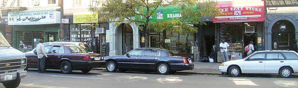
The main, east-west thoroughfare portion of 116th Street begins at the eastern edge of Morningside Park and runs east through central Harlem. A large West African immigrant community has developed in central Harlem with stores, bakeries and cafés along 116th Street west of St. Nicholas Avenue. This community has been called Little Senegal or Le Petit Senegal.[5]
At Lenox Ave., the street runs past the Malcolm Shabazz Mosque, formerly the Mosque No. 7. The building was erected as the Lenox Casino.[6]
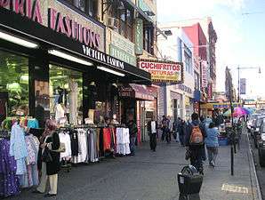
East of Fifth Avenue, 116th Street has historically been the primary business hub of Spanish Harlem. From Lexington Avenue to First Avenue, the street is lined with businesses selling food, clothing, and other specialty and ethnically specific goods to a Spanish-speaking clientele. East 116th Street terminates at FDR Drive, the site of the East River Plaza, a retail mall complex with large commercial tenants Costco, Target, Best Buy and Marshalls.[7][8]
Transportation
Subway stations on 116th Street are, from west to east:
- 116th Street – Columbia University serving the 1 train at Broadway
- 116th Street serving the A B C trains at Frederick Douglass Boulevard
- 116th Street serving the 2 3 trains at Lenox Avenue
- 116th Street serving the 4 6 <6> trains at Lexington Avenue
The M116 New York City Bus route also stops on the street.
Gallery
-

Termination of 116th Street at Riverside Drive
-

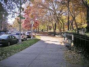
Looking west from Morningside Drive; Morningside Park is behind the camera.
-

Carl Schurz statue at the 116th Street overlook at Morningside Park.
-
Morningside Avenue, east side of the park. 115th Street buildings in background.
-
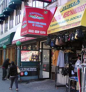
116th Street at Eighth Avenue in Harlem, and the uptown entrance to 116th Street station (A B C trains).
-
West African stores between Adam Clayton Powell Jr. Boulevard and Eighth Avenue in Harlem.
-
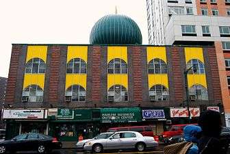
Malcolm Shabazz Mosque, 116th and Lenox Avenue.
-
El Barrio, 116th Street between Third Avenue and Lexington Avenue.
See also
- 116th Street Crew, a Mafia crew with the Genovese crime family
- Ciro Terranova, the "Artichoke King" moved to 138 East 116th Street after declaring bankruptcy and foreclosing on his home
- Morello crime family, the Morellos owned the building at 338 East 116th Street, the headquarters of the Aignatz Aflorio Co-operative association
| Wikimedia Commons has media related to 116th Street (Manhattan). |
References
- ↑ Morris, Gouverneur, De Witt, Simeon, and Rutherford, John [sic] (March 1811) "Remarks Of The Commissioners For Laying Out Streets And Roads In The City Of New York, Under The Act Of April 3, 1807", Cornell University Library. Accessed June 27, 2016. "These streets are all sixty feet wide except fifteen, which are one hundred feet wide, viz.: Numbers fourteen, twenty-three, thirty-four, forty-two, fifty-seven, seventy-two, seventy-nine, eighty-six, ninety-six, one hundred and six, one hundred and sixteen, one hundred and twenty-five, one hundred and thirty-five, one hundred and forty-five, and one hundred and fifty-five--the block or space between them being in general about two hundred feet."
- ↑ Gray, Christopher, Streetscapes/The Colosseum and the Paterno, 116th Street and Riverside Drive; At Curves in the Road, 2 Unusually Shaped Buildings ", The New York Times, August 15, 1999.
- ↑ Gray, Christopher. "Streetscapes/The Colosseum and the Paterno, 116th Street and Riverside Drive; At Curves in the Road, 2 Unusually Shaped Buildings", The New York Times, August 15, 1999.
- ↑ "COLUMBIA PUTTING NEW WALK IN SHAPE; Transformation of 116th Street Block Into a Campus Artery Moving Toward Completion", The New York Times, November 17, 1953. Accessed August 21, 2008.
- ↑ Attah, Ayesha. "Mourides Celebrate 19 Years in North America", The African. Accessed October 23, 2007. "116th Street in Harlem, New York is aptly named Le Petit Senegal. It abounds in aromas of stewing mafe and yassa wafting out of restaurants, sidewalks turned into mosques and businesses stocked with merchandise right out of Dakar."
- ↑ Norval White and Elliot Willensky, AIA Guide to New York City, Fourth Edition, 2000, p. 494.
- ↑ "East River Plaza | PlanNYC", Accessed August 25, 2009. Archived 2009-09-03.
- ↑ "Squeezing Big-Box Retailing Into Small City Spaces", The New York Times, June 11, 2008. Accessed August 25, 2009.