155th Street (Manhattan)
Coordinates: 40°49′52″N 73°56′32″W / 40.8312°N 73.9422°W
155th Street are two crosstown streets in the Harlem and Washington Heights neighborhood, in the New York City borough of Manhattan. It also serves as the border between Harlem and Washington Heights neighborhoods of Manhattan,They are the northernmost of the 155 crosstown streets mapped out in the Commissioner's Plan of 1811 that established the numbered street grid in Manhattan.[1] The street consists of a "high portion" which is a major artery through the area, as well as a lesser-used "low portion".
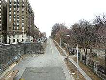
The high portion of 155th Street starts on the West Side at Riverside Drive, crossing Broadway, Amsterdam Avenue and Saint Nicholas Avenue. At Saint Nicholas Place, the terrain drops off steeply, forming Coogan's Bluff. 155th Street is carried on a 1,600-foot (490 m) long viaduct, a City Landmark constructed in 1893, that slopes down towards the Harlem River, continuing onto the Macombs Dam Bridge, crossing over (but not intersecting with) the Harlem River Drive.[2] A separate, unconnected section of 155th Street runs under the viaduct, connecting Bradhurst Avenue and the Harlem River Drive. The New York City Subway serves the high part of 155th Street at 155th Street on the IND Eighth Avenue Line and the low part at 155th Street on the IND Concourse Line.
Points of interest
- Highbridge Park – situated on the banks of the Harlem River near the northernmost tip of Manhattan, between 155th Street and Dyckman Street.[3]
- Polo Grounds – The second and third (final) incarnations of the famed stadium were located at was then 8th Avenue from 1911 to 1963, in Coogan's Hollow on the north side of the viaduct. Over its life, it was home of the New York Giants (1911–1957), New York Yankees (1913–1922) and New York Mets (1962–1963) baseball franchises, and the New York Giants (1925–1955) and New York Jets (1960–1963) football teams.
- Rucker Park – located at Frederick Douglass Boulevard, Rucker Park is one of the premier havens of streetball, and its summer league has been the launching point for many NBA players.[4]
- Hispanic Society of America – Museum of Spanish, Portuguese, and Latin American art and artifacts, as well as a rare books and manuscripts and research library, located at Audubon Terrace.
- Trinity Church Cemetery and Mausoleum, on the south side of 155th between Broadway and Riverside Drive.
References
- ↑ REMARKS OF THE COMMISSIONERS FOR LAYING OUT STREETS AND ROADS IN THE CITY OF NEW YORK, UNDER THE ACT OF APRIL 3, 1807, accessed May 2, 2007. "These streets are all sixty feet wide except fifteen, which are one hundred feet wide, viz.: Numbers fourteen, twenty-three, thirty-four, forty-two, fifty-seven, seventy-two, seventy-nine, eighty-six, ninety-six, one hundred and six, one hundred and sixteen, one hundred and twenty-five, one hundred and thirty-five, one hundred and forty-five, and one hundred and fifty-five—the block or space between them being in general about two hundred feet."
- ↑ Gray, Christopher. "Streetscapes/The 155th Street Viaduct; An Elevated 1893 Roadway With a Lacy Elegance", The New York Times, July 9, 2000. Accessed November 10, 2007.
- ↑ Highbridge Park, New York City Department of Parks and Recreation. Accessed November 10, 2007.
- ↑ Directions to Rucker Park, InsideHoops.com. Accessed November 10, 2007.
External links
| Wikimedia Commons has media related to 155th Street (Manhattan). |
- I Can't Drive 155, Forgotten-NY