Abbeville, Alabama
| Abbeville | |
|---|---|
| City | |
|
Historic Downtown Abbeville, Alabama | |
 Location in Henry County and the state of Alabama | |
 Abbeville Location in the United States | |
| Coordinates: 31°33′59″N 85°15′5″W / 31.56639°N 85.25139°W | |
| Country | United States |
| State | Alabama |
| County | Henry |
| Government | |
| • Mayor | James Giganti Jr. |
| Area | |
| • Total | 15.6 sq mi (40.4 km2) |
| • Land | 15.5 sq mi (40.3 km2) |
| • Water | 0.1 sq mi (0.1 km2) 0.32% |
| Elevation | 449 ft (137 m) |
| Population (2010)[1] | |
| • Total | 2,688 |
| • Density | 192/sq mi (74.1/km2) |
| Time zone | CST (UTC-6) |
| • Summer (DST) | CDT (UTC-5) |
| ZIP code | 36310 |
| Area code(s) | 334 |
| FIPS code | 01-00124 |
| |

Abbeville is a city in Henry County, Alabama, United States. It is part of the Dothan, Alabama Metropolitan Statistical Area. At the 2010 census, the population was 2,688.[2] The city is the county seat of Henry County. It is the first city alphabetically, both by city and state, in the Rand McNally Road Atlas. It is home to two high schools: Abbeville High School and Abbeville Christian Academy. It holds chapters of the Red Cross and Habitat for Humanity.
Geography
Abbeville is located at 31°33′59″N 85°15′5″W / 31.56639°N 85.25139°WCoordinates: 31°33′59″N 85°15′5″W / 31.56639°N 85.25139°W (31.566367, -85.251300).[3] The city is located in southeastern Alabama along U.S. Route 431, Alabama State Route 10, and Alabama State Route 27 approximately 25 mi (40 km) northeast of Dothan and 23 mi (37 km) south-southwest of Eufaula.
According to the U.S. Census Bureau, the city has a total area of 15.6 square miles (40 km2), of which 15.6 square miles (40 km2) is land and 0.1 square miles (0.26 km2) (0.32%) is water.
Climate
The climate in this area is characterized by hot, humid summers and generally mild to cool winters. According to the Köppen Climate Classification system, Abbeville has a humid subtropical climate, abbreviated "Cfa" on climate maps.[4]
History
Abbeville is the oldest remaining colonial settlement in East Alabama from Florida to the Tennessee line. Its older than the county of Henry and the State of Alabama. The city was named for "Abbe", a local Muscogee Indian man at the time of the town's settlement. The name means "a grove of dogwood trees". An active trading post was located in Abbeville in Alabama Territory early in 1819. The first settler gateway to the wiregrass was at Franklin located fourteen miles west of Abbeville.
It was designated the Henry County seat in 1833, gaining the distinction from Columbia. It was formally incorporated in 1853.[5]
In 1937, an African-American young man named Wes Johnson was accused of attacking a white woman and arrested. He was then removed from the Henry County jail and lynched by a mob of white men, his body found "bullet marked" and "swinging from a tree."[6] None of the members of the mob were charged with a crime.[7] A case did appear in front of the Alabama Supreme Court over impeaching the sheriff who was supposed to have been protecting Johnson. While the Alabama Attorney General openly declared that Johnson was innocent, the sheriff avoided impeachment.[8]
In 1944, an activist African-American woman, Recy Taylor, was gang-raped by six white men. Even though the men admitted the rape to authorities, two grand juries subsequently declined to indict the men (as documented in the book, At the Dark End of the Street).[9] From a historic point of view, "The Recy Taylor case brought the building blocks of the Montgomery bus boycott together a decade earlier."[10]
In 1950 Abbeville had a population of 2,162.[11]
Demographics
| Historical population | |||
|---|---|---|---|
| Census | Pop. | %± | |
| 1850 | 300 | — | |
| 1890 | 465 | — | |
| 1900 | 889 | 91.2% | |
| 1910 | 1,141 | 28.3% | |
| 1920 | 1,267 | 11.0% | |
| 1930 | 2,047 | 61.6% | |
| 1940 | 2,080 | 1.6% | |
| 1950 | 2,162 | 3.9% | |
| 1960 | 2,524 | 16.7% | |
| 1970 | 2,996 | 18.7% | |
| 1980 | 3,155 | 5.3% | |
| 1990 | 3,173 | 0.6% | |
| 2000 | 2,987 | −5.9% | |
| 2010 | 2,688 | −10.0% | |
| Est. 2015 | 2,620 | [12] | −2.5% |
| U.S. Decennial Census[13] 2013 Estimate[14] | |||
As of the census[15] of 2000, there were 2,987 people, 1,172 households, and 787 families residing in the city. The population density was 192.0 people per square mile (74.1/km²). There were 1,353 housing units at an average density of 86.9 per square mile (33.6/km²). The racial makeup of the city was 56.65% White, 39.94% Black or African American, 0.07% Asian, 2.85% from other races, and 0.50% from two or more races. 3.52% of the population were Hispanic or Latino.
There were 1,172 households out of which 27.2% had children under the age of 18 living with them, 45.8% were married couples living together, 17.8% had a female householder with no husband present, and 32.8% were non-families. 30.8% of all households were made up of individuals and 17.4% had someone living alone who was 65 years of age or older. The average household size was 2.41 and the average family size was 3.01.
In the city the population was spread out with 22.9% under the age of 18, 8.4% from 18 to 24, 22.1% from 25 to 44, 22.8% from 45 to 64, and 23.8% who were 65 years of age or older. The median age was 42 years. For every 100 females there were 82.6 males. For every 100 females age 18 and over, there were 78.2 males.
The median income for a household in the city was $23,266, and the median income for a family was $37,917. Males had a median income of $26,250 versus $20,603 for females. The per capita income for the city was $17,215. About 17.3% of families and 21.5% of the population were below the poverty line, including 21.1% of those under age 18 and 29.6% of those age 65 or over.
2010 census
As of the census[15] of 2010, there were 2,688 people, 1,077 households, and 699 families residing in the city. The population density was 192.0 people per square mile (74.1/km²). There were 1,255 housing units at an average density of 80.4 per square mile (31.1/km²). The racial makeup of the city was 54.4% White, 41.4% Black or African American, 1.0% Asian, 2.0% from other races, and 1.2% from two or more races. 3.1% of the population were Hispanic or Latino.
There were 1,077 households out of which 24.9% had children under the age of 18 living with them, 41.1% were married couples living together, 19.1% had a female householder with no husband present, and 35.1% were non-families. 32.4% of all households were made up of individuals and 16.3% had someone living alone who was 65 years of age or older. The average household size was 2.32 and the average family size was 2.94.
In the city the population was spread out with 22.0% under the age of 18, 7.5% from 18 to 24, 21.3% from 25 to 44, 25.5% from 45 to 64, and 23.7% who were 65 years of age or older. The median age was 44.3 years. For every 100 females there were 85.1 males. For every 100 females age 18 and over, there were 93.1 males.
The median income for a household in the city was $28,533, and the median income for a family was $39,167. Males had a median income of $36,630 versus $25,302 for females. The per capita income for the city was $17,756. About 16.2% of families and 18.5% of the population were below the poverty line, including 25.2% of those under age 18 and 17.8% of those age 65 or over.
Government
Abbeville is governed via a mayor-council government. The mayor is elected at large. The city council consists of five members who are elected from districts.
Media
Abbeville is served by one radio station, WESZ-LP.
Education
Public schools
Abbeville is a part of the Henry County Public Schools system.
Private schools
Transportation
Intercity bus service is provided by Greyhound Lines.[16]
Notable people
- Leroy Cook, former defensive end for the Dallas Cowboys
- William Calvin Oates Civil War and Spanish–American War veteran
- Chris Porter, former Auburn University basketball player and professional basketball player
- Al Richardson, former American football linebacker for the Atlanta Falcons
- Recy Taylor, an African-American woman whose gang-rape in Abbeville by six white men provided an early organizational spark for the nationwide Civil Rights movement.[17]
Gallery
-

The Henry County Courthouse is located in Abbeville.
-

Abbeville City Hall and Police Department
-

Abbeville Post Office (ZIP code: 36310)
-

Abbeville Memorial Library
-

Atlantic Coast Line Railroad Depot in Abbeville.
-

The Archie Theatre was first opened in Abbeville on July 1, 1948.
-
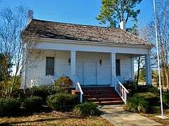
The Bethune-Kennedy House is a rare, dual front door, double pen Creole cottage which was constructed circa 1840 and is the oldest remaining structure in Abbeville. It was placed on the National Register of Historic Places on January 5, 1978.

References
- ↑ "Annual Estimates of the Population for Incorporated Places in Alabama". United States Census Bureau. 2008-07-10. Retrieved 2008-07-14.
- ↑ "Profile of General Population and Housing Characteristics: 2010 Demographic Profile Data for Abbeville city, Alabama". U.S. Census Bureau. 2010. Retrieved 2012-11-10.
- ↑ "US Gazetteer files: 2010, 2000, and 1990". United States Census Bureau. 2011-02-12. Retrieved 2011-04-23.
- ↑ Climate Summary for Abbeville, Alabama
- ↑ http://www.encyclopediaofalabama.org/article/h-2505
- ↑ "Suspect Lynched by Alabama Mob". The Washington Post. 3 February 1937.
- ↑ "No Indictments on Alabama Lynchers; Impeachment?". Atlanta Daily World. 12 February 1937.
- ↑ "Alabama Sheriff Saved by Court". The Pittsburgh Courier. 3 July 1937.
- ↑ "Book Discussion on At the Dark End of the Street". www.c-span.org. C-SPAN. 28 September 2010. Retrieved 29 March 2015.
- ↑ McGuire, Danielle L. (2010). At the Dark End of the Street: Black Women, Rape, and Resistance- A New History of the Civil Rights Movement from Rosa Parks to the Rise of Black Power. Random House. pp. xv–xvii. ISBN 978-0-307-26906-5., page 39
- ↑ Encyclopædia Britannica Atlas, 1959 Edition, p. 298.
- ↑ "Annual Estimates of the Resident Population for Incorporated Places: April 1, 2010 to July 1, 2015". Retrieved July 2, 2016.
- ↑ "U.S. Decennial Census". Census.gov. Archived from the original on 11 May 2015. Retrieved June 6, 2013.
- ↑ "Annual Estimates of the Resident Population: April 1, 2010 to July 1, 2013". Retrieved June 3, 2014.
- 1 2 "American FactFinder". United States Census Bureau. Archived from the original on 11 September 2013. Retrieved 2008-01-31.
- ↑ http://locations.greyhound.com/bus-stations/us/alabama/abbeville/greyhound-420013
- ↑ McGuire, At the Dark End of the Street, p. 39.
External links
| Wikimedia Commons has media related to Abbeville, Alabama. |
Municipalities and communities of Henry County, Alabama, United States | ||
|---|---|---|
| Cities | 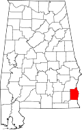 | |
| Towns | ||
| Unincorporated communities | ||
| Footnotes | ‡This populated place also has portions in an adjacent county or counties | |