Headland, Alabama
| Headland | |
|---|---|
| City | |
|
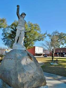
This statue of a World War I doughboy, with his arm outstretched, honors all of Headland's military dead. It stands at the center of Headland Public Square. | |
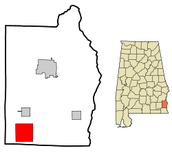 Location in Henry County and the state of Alabama | |
| Coordinates: 31°21′12″N 85°20′23″W / 31.35333°N 85.33972°W | |
| Country | United States |
| State | Alabama |
| County | Henry |
| Area | |
| • Total | 16 sq mi (41.5 km2) |
| • Land | 16 sq mi (41.5 km2) |
| • Water | 0 sq mi (0 km2) |
| Elevation | 404 ft (123 m) |
| Population (2010) | |
| • Total | 4,510 |
| • Density | 220.2/sq mi (84.9/km2) |
| Time zone | Central (CST) (UTC−6) |
| • Summer (DST) | CDT (UTC−5) |
| ZIP code | 36345 |
| Area code | 334 |
| FIPS code | 01-33856 |
| GNIS feature ID | 0119910 |
| Website | http://www.headlandalabama.org/ |
Headland is the largest city in Henry County, Alabama, United States. It is part of the Dothan, Alabama metropolitan area. At the 2010 census the population was 4,510. Ray Marler is the current mayor.
History
James Joshua Head (1839–1927) founded Headland in 1871 as "Head's Land". He patented land, plotted the town and built his home. The Post Office opened, as Headland, on October 10, 1871.
The Headland Public Square was laid off in 1871 by J.J. Head with a vision for a branch courthouse. Henry County voters decided in the 1879 and 1885 court house site elections not to locate a court house on the public square, Henry has been Alabama's only county with three court houses at the same time.
J.J. Head sold Headland to Hosey C. Powell in 1879, who sold to Dr. Wyatt S. Oates in 1880. J.J. Head moved to Tampa, Florida in 1883 and later established Lake Magdalene, Florida.
Headland incorporated in 1884 with 26 white and 4 black petitioners. The railroad was built in 1893 along with the Seaboard Coast Line Railroad Depot. The depot was added to the National Register of Historic Places on September 4, 1980. It has since been disassembled.
Headland's "Spirit of the American Doughboy" statue was the first public statue in Henry County. It was erected on the square in 1926 as a tribute to the town's military dead. The square was paved in 1935.
As of the 1960 U.S. Census, Headland had grown into Henry County's largest city, narrowly edging out Abbeville, which had been the largest since Dothan was removed into Houston County in 1903. It lost that distinction to Abbeville again in 1970, but regained it in 1980 and has since solidified its hold. In 2000, it broke Dothan's then-Henry County 1900 record of 3,275 residents with 3,523 and added nearly 1,000 more by 2010.
Geography
Headland is located at 31°21′12″N 85°20′23″W / 31.35333°N 85.33972°W (31.353410, -85.339793).[1]
According to the U.S. Census Bureau, the city has a total area of 16.0 square miles (41 km2), of which 16.0 square miles (41 km2) is land and 0.06% is water.
Demographics
| Historical population | |||
|---|---|---|---|
| Census | Pop. | %± | |
| 1900 | 602 | — | |
| 1910 | 1,090 | 81.1% | |
| 1920 | 1,252 | 14.9% | |
| 1930 | 1,811 | 44.6% | |
| 1940 | 2,052 | 13.3% | |
| 1950 | 2,091 | 1.9% | |
| 1960 | 2,650 | 26.7% | |
| 1970 | 2,545 | −4.0% | |
| 1980 | 3,327 | 30.7% | |
| 1990 | 3,266 | −1.8% | |
| 2000 | 3,523 | 7.9% | |
| 2010 | 4,510 | 28.0% | |
| Est. 2015 | 4,736 | [2] | 5.0% |
| U.S. Decennial Census[3] 2013 Estimate[4] | |||
As of the census[5] of 2000, there were 3,523 people, 1,423 households, and 1,027 families residing in the city. The population density was 219.7 people per square mile (84.9/km²). There were 1,516 housing units at an average density of 94.6 per square mile (36.5/km²). The racial makeup of the city was 67.53% White, 31.28% Black or African American, 0.20% Native American, 0.09% Asian, 0.03% from other races, and 0.88% from two or more races. 0.20% of the population were Hispanic or Latino of any race.
There were 1,423 households out of which 33.1% had children under the age of 18 living with them, 50.5% were married couples living together, 18.7% had a female householder with no husband present, and 27.8% were non-families. 25.7% of all households were made up of individuals and 12.0% had someone living alone who was 65 years of age or older. The average household size was 2.47 and the average family size was 2.94.
In the city the age distribution of the population shows 25.9% under the age of 18, 8.1% from 18 to 24, 26.8% from 25 to 44, 24.3% from 45 to 64, and 14.8% who were 65 years of age or older. The median age was 37 years. For every 100 females there were 84.5 males. For every 100 females age 18 and over, there were 77.7 males.
The median income for a household in the city was $34,388, and the median income for a family was $42,150. Males had a median income of $33,500 versus $20,165 for females. The per capita income for the city was $17,069. About 10.6% of families and 14.7% of the population were below the poverty line, including 20.8% of those under age 18 and 15.0% of those age 65 or over.
2010 census
As of the census[6] of 2010, there were 4,510 people, 1,799 households, and 1,291 families residing in the city. The population density was 281.9 people per square mile (108.7/km²). There were 1,949 housing units at an average density of 121.8 per square mile (47.0/km²). The racial makeup of the city was 70.1% White, 27.5% Black or African American, 0.4% Native American, 0.3% Asian, 0.6% from other races, and 1.2% from two or more races. 1.4% of the population were Hispanic or Latino of any race.
There were 1,799 households out of which 30.1% had children under the age of 18 living with them, 50.1% were married couples living together, 17.7% had a female householder with no husband present, and 28.2% were non-families. 25.3% of all households were made up of individuals and 12.3% had someone living alone who was 65 years of age or older. The average household size was 2.50 and the average family size was 2.99.
In the city the age distribution of the population shows 25.6% under the age of 18, 6.7% from 18 to 24, 26.6% from 25 to 44, 27.0% from 45 to 64, and 14.1% who were 65 years of age or older. The median age was 38.3 years. For every 100 females there were 83.7 males. For every 100 females age 18 and over, there were 82.9 males.
The median income for a household in the city was $45,813, and the median income for a family was $50,120. Males had a median income of $37,025 versus $30,734 for females. The per capita income for the city was $20,304. About 13.6% of families and 12.1% of the population were below the poverty line, including 8.7% of those under age 18 and 20.7% of those age 65 or over.
Sports
Headland was home to the Headland Dixie Runners, a minor league baseball team in the Alabama State League/Alabama–Florida League from 1950 to 1952.
Notable people
- M. Watt Espy, death penalty historian
- W. Thomas West, former Major General in the U.S. Air Force
- Charles Woods, businessman and political candidate
- Miss Alabama USA, Pamela Flowers, Miss Headland 1973, Miss Alabama USA 1975, 1st runner up to Miss USA, Miss Photogenic
- Miss Alabama USA, Keisha Walding, Miss Headland 2000, Miss Alabama USA 2008
Gallery
 Headland City Hall (Erected 1930)

References
- ↑ "US Gazetteer files: 2010, 2000, and 1990". United States Census Bureau. 2011-02-12. Retrieved 2011-04-23.
- ↑ "Annual Estimates of the Resident Population for Incorporated Places: April 1, 2010 to July 1, 2015". Retrieved July 2, 2016.
- ↑ "U.S. Decennial Census". Census.gov. Retrieved June 6, 2013.
- ↑ "Annual Estimates of the Resident Population: April 1, 2010 to July 1, 2013". Retrieved June 3, 2014.
- ↑ "American FactFinder". United States Census Bureau. Retrieved 2008-01-31.
- ↑ "American FactFinder". United States Census Bureau. Retrieved 2015-07-25.
External links
Coordinates: 31°21′12″N 85°20′23″W / 31.35341°N 85.339793°W
Municipalities and communities of Henry County, Alabama, United States | ||
|---|---|---|
| Cities |  | |
| Towns | ||
| Unincorporated communities | ||
| Footnotes | ‡This populated place also has portions in an adjacent county or counties | |