Adams County, Idaho
| Adams County, Idaho | ||
|---|---|---|
|
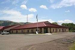
Adams County Courthouse | ||
| ||
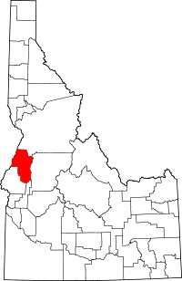 Location in the U.S. state of Idaho | ||
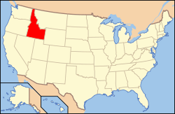 Idaho's location in the U.S. | ||
| Founded | March 3, 1911 | |
| Named for | John Adams | |
| Seat | Council | |
| Largest city | Council | |
| Area | ||
| • Total | 1,370 sq mi (3,548 km2) | |
| • Land | 1,363 sq mi (3,530 km2) | |
| • Water | 6.7 sq mi (17 km2), 0.5% | |
| Population | ||
| • (2010) | 3,976 | |
| • Density | 2.9/sq mi (1/km²) | |
| Congressional district | 1st | |
| Time zone | Mountain: UTC-7/-6 | |
| Website |
www | |

Adams County is a rural county located in the state of Idaho. As of the 2010 census the county had a population of 3,976,[1] making it the fifth-least populous county in Idaho. The county seat and largest city is Council.[2] The county was established in 1911 and was named in honor of President John Adams.[3]
Adams County is home to the Brundage Mountain ski area, northeast of New Meadows, and the Idaho ground squirrel.
Geography
According to the U.S. Census Bureau, the county has a total area of 1,370 square miles (3,500 km2), of which 1,363 square miles (3,530 km2) is land and 6.7 square miles (17 km2) (0.5%) is water.[4]
Adjacent counties
- Idaho County - north
- Valley County - east
- Gem County - southeast
- Washington County - south
- Baker County, Oregon - southwest
- Wallowa County, Oregon - northwest
Highways
National protected areas
- Hells Canyon National Recreation Area (part)
- Payette National Forest (part)
Demographics
| Historical population | |||
|---|---|---|---|
| Census | Pop. | %± | |
| 1920 | 2,966 | — | |
| 1930 | 2,867 | −3.3% | |
| 1940 | 3,407 | 18.8% | |
| 1950 | 3,347 | −1.8% | |
| 1960 | 2,978 | −11.0% | |
| 1970 | 2,877 | −3.4% | |
| 1980 | 3,347 | 16.3% | |
| 1990 | 3,254 | −2.8% | |
| 2000 | 3,476 | 6.8% | |
| 2010 | 3,976 | 14.4% | |
| Est. 2015 | 3,843 | [5] | −3.3% |
| U.S. Decennial Census[6] 1790-1960[7] 1900-1990[8] 1990-2000[9] 2010-2013[1] | |||
2000 census
As of the census[10] of 2000, there were 3,476 people, 1,421 households, and 1,031 families residing in the county. The population density was 2.5 people per square mile (1.0/km²). There were 1,982 housing units at an average density of 2 per square mile (1/km²). The racial makeup of the county was 96.29% White, 1.41% Native American, 0.14% Asian, 0.06% Black or African American, 0.03% Pacific Islander, 0.92% from other races, and 1.15% from two or more races. 1.55% of the population were Hispanic or Latino of any race. 25.6% were of American, 17.9% German, 11.8% English and 7.0% Irish ancestry according to Census 2000.
There were 1,421 households out of which 28.00% had children under the age of 18 living with them, 63.30% were married couples living together, 5.70% had a female householder with no husband present, and 27.40% were non-families. 23.20% of all households were made up of individuals and 9.90% had someone living alone who was 65 years of age or older. The average household size was 2.42 and the average family size was 2.83.
In the county the population was spread out with 23.90% under the age of 18, 4.60% from 18 to 24, 22.60% from 25 to 44, 32.70% from 45 to 64, and 16.10% who were 65 years of age or older. The median age was 44 years. For every 100 females there were 105.40 males. For every 100 females age 18 and over, there were 102.10 males.
The median income for a household in the county was $28,423, and the median income for a family was $32,335. Males had a median income of $29,097 versus $14,408 for females. The per capita income for the county was $14,908. About 11.70% of families and 15.10% of the population were below the poverty line, including 16.90% of those under age 18 and 11.70% of those age 65 or over.
2010 census
As of the 2010 United States Census, there were 3,976 people, 1,748 households, and 1,185 families residing in the county.[11] The population density was 2.9 inhabitants per square mile (1.1/km2). There were 2,636 housing units at an average density of 1.9 per square mile (0.73/km2).[12] The racial makeup of the county was 96.1% white, 1.0% American Indian, 0.4% Asian, 0.1% Pacific islander, 0.1% black or African American, 0.7% from other races, and 1.7% from two or more races. Those of Hispanic or Latino origin made up 2.4% of the population.[11] In terms of ancestry, 26.3% were German, 18.0% were English, 14.6% were Irish, and 4.9% were American.[13]
Of the 1,748 households, 22.3% had children under the age of 18 living with them, 58.6% were married couples living together, 5.8% had a female householder with no husband present, 32.2% were non-families, and 26.8% of all households were made up of individuals. The average household size was 2.26 and the average family size was 2.70. The median age was 50.0 years.[11]
The median income for a household in the county was $36,004 and the median income for a family was $45,590. Males had a median income of $31,050 versus $26,413 for females. The per capita income for the county was $22,730. About 8.8% of families and 12.4% of the population were below the poverty line, including 13.5% of those under age 18 and 13.5% of those age 65 or over.[14]
Communities
Cities
Unincorporated communities
- Bear
- Beer Bottle Crossing
- Cuprum
- Fruitvale
- Goodrich
- Indian Valley
- Meadows
- Mesa
- Tamarack - (not the defunct Tamarack Resort in Valley Co.)
See also
References
- 1 2 "State & County QuickFacts". United States Census Bureau. Retrieved June 28, 2014.
- ↑ "Find a County". National Association of Counties. Archived from the original on 2011-05-31. Retrieved 2011-06-07.
- ↑ Idaho.gov - Adams County Archived August 10, 2009, at the Wayback Machine. - accessed 2009-06-05
- ↑ "US Gazetteer files: 2010, 2000, and 1990". United States Census Bureau. 2011-02-12. Retrieved 2011-04-23.
- ↑ "County Totals Dataset: Population, Population Change and Estimated Components of Population Change: April 1, 2010 to July 1, 2015". Retrieved July 2, 2016.
- ↑ "U.S. Decennial Census". United States Census Bureau. Archived from the original on May 11, 2015. Retrieved June 28, 2014.
- ↑ "Historical Census Browser". University of Virginia Library. Retrieved June 28, 2014.
- ↑ "Population of Counties by Decennial Census: 1900 to 1990". United States Census Bureau. Retrieved June 28, 2014.
- ↑ "Census 2000 PHC-T-4. Ranking Tables for Counties: 1990 and 2000" (PDF). United States Census Bureau. Retrieved June 28, 2014.
- ↑ "American FactFinder". United States Census Bureau. Archived from the original on 2013-09-11. Retrieved 2008-01-31.
- 1 2 3 "DP-1 Profile of General Population and Housing Characteristics: 2010 Demographic Profile Data". United States Census Bureau. Retrieved 2016-01-04.
- ↑ "Population, Housing Units, Area, and Density: 2010 - County". United States Census Bureau. Retrieved 2016-01-04.
- ↑ "DP02 SELECTED SOCIAL CHARACTERISTICS IN THE UNITED STATES – 2006-2010 American Community Survey 5-Year Estimates". United States Census Bureau. Retrieved 2016-01-04.
- ↑ "DP03 SELECTED ECONOMIC CHARACTERISTICS – 2006-2010 American Community Survey 5-Year Estimates". United States Census Bureau. Retrieved 2016-01-04.
External links
- Adams County Assessor Parcel Map
- Adams County official website
- The Adams County Record - local newspaper
- Brundage Mountain ski area
 |
Wallowa County, Oregon | Idaho County | | |
| |
Valley County | |||
| ||||
| | ||||
| Baker County, Oregon | Washington County | Gem County |
Municipalities and communities of Adams County, Idaho, United States | ||
|---|---|---|
| Cities | ||
| Unincorporated communities | ||
Coordinates: 44°54′N 116°27′W / 44.90°N 116.45°W