Gem County, Idaho
| Gem County, Idaho | ||
|---|---|---|
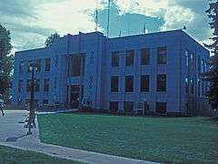 Gem County Courthouse | ||
| ||
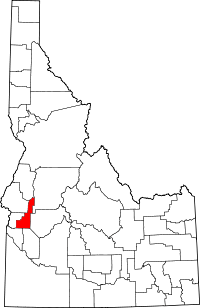 Location in the U.S. state of Idaho | ||
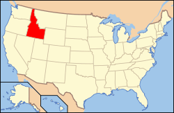 Idaho's location in the U.S. | ||
| Founded | March 15, 1915 | |
| Named for | the state nickname, "Gem State". | |
| Seat | Emmett | |
| Largest city | Emmett | |
| Area | ||
| • Total | 566 sq mi (1,466 km2) | |
| • Land | 561 sq mi (1,453 km2) | |
| • Water | 4.8 sq mi (12 km2), 0.8% | |
| Population | ||
| • (2010) | 16,719 | |
| • Density | 30/sq mi (12/km²) | |
| Congressional district | 1st | |
| Time zone | Mountain: UTC-7/-6 | |
| Website |
www | |

Gem County is a county in the U.S. state of Idaho. As of the 2010 census, the population was 16,719.[1] The county seat and largest city is Emmett.[2]
Gem County is part of the Boise, ID Metropolitan Statistical Area.
Gem County is home to the Idaho ground squirrel.
Traffic Signals
- Main & Washington (Hwy 52) Emmett
- 4th & Washington (Hwy 52) Emmett
- Hwy 16/Hwy 52/Washington Emmett
- Hwy 16 & Johns Emmett
- Hwy 16 & Substation Emmett
History
Named for the state nickname, "Gem State," the county was established on March 15, 1915, partitioned from Canyon County and Boise County. Fur trappers were in the area as early as 1818, and Alexander Ross explored Squaw Creek in 1824. Prospectors and miners moved through the county in 1862 en route to the gold rush in the Boise Basin around Idaho City, and by the next year irrigation began along the Payette River.[3] The Black Canyon diversion dam on the river was built in the early 1920s, east of Emmett.[4]
Geography
According to the U.S. Census Bureau, the county has a total area of 566 square miles (1,470 km2), of which 561 square miles (1,450 km2) is land and 4.8 square miles (12 km2) (0.8%) is water.[5] It is the fifth-smallest county in Idaho by area.
Adjacent counties
- Adams County - north
- Valley County - northeast
- Boise County - east
- Ada County - south
- Canyon County - southwest
- Payette County - west
- Washington County - northwest
National protected area
- Boise National Forest (part)
Demographics
| Historical population | |||
|---|---|---|---|
| Census | Pop. | %± | |
| 1920 | 6,427 | — | |
| 1930 | 7,419 | 15.4% | |
| 1940 | 9,544 | 28.6% | |
| 1950 | 8,730 | −8.5% | |
| 1960 | 9,127 | 4.5% | |
| 1970 | 9,387 | 2.8% | |
| 1980 | 11,972 | 27.5% | |
| 1990 | 11,844 | −1.1% | |
| 2000 | 15,181 | 28.2% | |
| 2010 | 16,719 | 10.1% | |
| Est. 2015 | 16,852 | [6] | 0.8% |
| U.S. Decennial Census[7] 1790-1960[8] 1900-1990[9] 1990-2000[10] 2010-2013[1] | |||
2000 census
As of the census[11] of 2000, there were 15,181 people, 5,539 households, and 4,176 families residing in the county. The population density was 27 people per square mile (10/km²). There were 5,888 housing units at an average density of 10 per square mile (4/km²). The racial makeup of the county was 93.79% White, 0.73% Native American, 0.36% Asian, 0.07% Black or African American, 0.06% Pacific Islander, 3.16% from other races, and 1.83% from two or more races. 6.92% of the population were Hispanic or Latino of any race. 18.9% were of American, 17.5% German, 13.1% English and 7.2% Irish ancestry according to Census 2000.
There were 5,539 households out of which 34.00% had children under the age of 18 living with them, 63.40% were married couples living together, 8.40% had a female householder with no husband present, and 24.60% were non-families. 20.80% of all households were made up of individuals and 9.90% had someone living alone who was 65 years of age or older. The average household size was 2.70 and the average family size was 3.12.
In the county, the population was spread out with 28.00% under the age of 18, 7.60% from 18 to 24, 25.30% from 25 to 44, 23.50% from 45 to 64, and 15.60% who were 65 years of age or older. The median age was 38 years. For every 100 females, there were 98.70 males. For every 100 females age 18 and over, there were 96.70 males.
The median income for a household in the county was $34,460, and the median income for a family was $40,195. Males had a median income of $31,036 versus $20,755 for females. The per capita income for the county was $15,340. About 11.60% of families and 13.10% of the population were below the poverty line, including 15.60% of those under age 18 and 13.90% of those age 65 or over.
2010 census
As of the 2010 United States Census, there were 16,719 people, 6,495 households, and 4,611 families residing in the county.[12] The population density was 29.8 inhabitants per square mile (11.5/km2). There were 7,099 housing units at an average density of 12.7 per square mile (4.9/km2).[13] The racial makeup of the county was 93.4% white, 0.6% American Indian, 0.5% Asian, 0.1% Pacific islander, 0.1% black or African American, 3.1% from other races, and 2.2% from two or more races. Those of Hispanic or Latino origin made up 8.0% of the population.[12] In terms of ancestry, 23.2% were German, 19.2% were English, 15.8% were American, and 12.3% were Irish.[14]
Of the 6,495 households, 30.6% had children under the age of 18 living with them, 56.9% were married couples living together, 9.3% had a female householder with no husband present, 29.0% were non-families, and 24.3% of all households were made up of individuals. The average household size was 2.55 and the average family size was 3.01. The median age was 42.9 years.[12]
The median income for a household in the county was $42,794 and the median income for a family was $49,976. Males had a median income of $39,482 versus $31,083 for females. The per capita income for the county was $20,431. About 9.7% of families and 14.7% of the population were below the poverty line, including 17.3% of those under age 18 and 9.3% of those age 65 or over.[15]
Communities
City
Unincorporated communities
See also
References
- 1 2 "State & County QuickFacts". United States Census Bureau. Retrieved June 30, 2014.
- ↑ "Find a County". National Association of Counties. Archived from the original on May 31, 2011. Retrieved 2011-06-07.
- ↑ Idaho.gov - Gem County - accessed 2011-12-10
- ↑ USBR - Black Canyon div. dam Archived June 7, 2009, at the Wayback Machine.
- ↑ "US Gazetteer files: 2010, 2000, and 1990". United States Census Bureau. 2011-02-12. Retrieved 2011-04-23.
- ↑ "County Totals Dataset: Population, Population Change and Estimated Components of Population Change: April 1, 2010 to July 1, 2015". Retrieved July 2, 2016.
- ↑ "U.S. Decennial Census". United States Census Bureau. Archived from the original on May 11, 2015. Retrieved June 30, 2014.
- ↑ "Historical Census Browser". University of Virginia Library. Retrieved June 30, 2014.
- ↑ "Population of Counties by Decennial Census: 1900 to 1990". United States Census Bureau. Retrieved June 30, 2014.
- ↑ "Census 2000 PHC-T-4. Ranking Tables for Counties: 1990 and 2000" (PDF). United States Census Bureau. Retrieved June 30, 2014.
- ↑ "American FactFinder". United States Census Bureau. Archived from the original on September 11, 2013. Retrieved 2008-01-31.
- 1 2 3 "DP-1 Profile of General Population and Housing Characteristics: 2010 Demographic Profile Data". United States Census Bureau. Retrieved 2016-01-09.
- ↑ "Population, Housing Units, Area, and Density: 2010 - County". United States Census Bureau. Retrieved 2016-01-09.
- ↑ "DP02 SELECTED SOCIAL CHARACTERISTICS IN THE UNITED STATES – 2006-2010 American Community Survey 5-Year Estimates". United States Census Bureau. Retrieved 2016-01-09.
- ↑ "DP03 SELECTED ECONOMIC CHARACTERISTICS – 2006-2010 American Community Survey 5-Year Estimates". United States Census Bureau. Retrieved 2016-01-09.
External links
 |
Washington County | Adams County | Valley County | |
| Payette County | |
Boise County | ||
| ||||
| | ||||
| Canyon County | Ada County |
Municipalities and communities of Gem County, Idaho, United States | ||
|---|---|---|
| City | ||
| Unincorporated communities | ||
Coordinates: 44°04′N 116°25′W / 44.06°N 116.41°W