Al-Hamraa
| Al-Hamraa الحمراء Al-Hamra | |
|---|---|
| Village | |
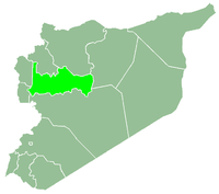
 Al-Hamraa Location in Syria | |
| Coordinates: 35°18′56″N 37°5′14″E / 35.31556°N 37.08722°E | |
| Country |
|
| Governorate | Hama |
| District | Hama |
| Subdistrict | Al-Hamraa |
| Population (2004) | |
| • Total | 1,783 |
Al-Hamraa (Arabic: الحمراء, also spelled al-Hamra) is a village in northwestern Syria, administratively part of the Hama Governorate, located northeast of Hama. Nearby localities include Jubb al-Othman to the northeast, Abu al-Thuhur to the north, Fan al-Shamali to the west, Maar Shahhur to the southwest, Salamiyah to the south and Sabburah to the southeast. According to the Syria Central Bureau of Statistics (CBS), al-Hamraa had a population of 1,783 in the 2004 census. It is the administrative center and second largest locality of the al-Hamraa nahiyah ("subdistrict") which consisted of 44 localities with a collective population of 32,604 in 2004.[1]
In 1838 al-Hamraa was classified as a khirba ("temporal village") in the District of Salamiyah.[2] It is situated near the Qasr ibn Wardan palace.
References
- ↑ General Census of Population and Housing 2004. Syria Central Bureau of Statistics (CBS). Hama Governorate. (Arabic)
- ↑ Smith, 1841, p. 178.
Bibliography
- Smith, Eli; Robinson, Edward (1841). Biblical Researches in Palestine, Mount Sinai and Arabia Petraea: A Journal of Travels in the Year 1838. 3. Crocker and Brewster.