Uqayribat
| Uqayribat عقيربات Oqeirbat, Aqayrbat | |
|---|---|
| Town | |
 Uqayribat Location in Syria | |
| Coordinates: 35°02′35″N 37°27′57″E / 35.043050°N 37.465696°ECoordinates: 35°02′35″N 37°27′57″E / 35.043050°N 37.465696°E | |
| Country |
|
| Governorate | Hama |
| District | Salamiyah |
| Subdistrict | Uqayribat |
| Founded | 1900 |
| Occupation |
|
| Population (2004) | |
| • Total | 2,745 |
| Time zone | EET (UTC+2) |
| • Summer (DST) | EEST (UTC+3) |
| City Qrya Pcode | C3315 |
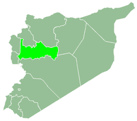
′Uqayribat (Arabic: عقيربات ALA-LC: ′Uqêriba′) also spelled Oqeirbat, Uzeiribat, ′Aqayrbat, ′Agareb, Aaqerbate, Occariba or Occaraba is a Syrian town in the Uqayribat Subdistrict of the Salamiyah District in Hama Governorate. It is situated at the western foot of Jabal Bal'as and along the route connecting Palmyra (Tadmur) to the southeast with al-Salamiyah to the west.[1] According to the Syria Central Bureau of Statistics (CBS), ′Uqayribat had a population of 2,745 in the 2004 census.[2]
History
Uqayribat is identified as the site of the Roman-era town of Occaraba, listed on the Peutinger Table.[3] In the Notitia Dignitatum, a Roman document, Occaraba is mentioned as a garrison of the equites promoti Illyriciani legion.[4] The Czech explorer Alois Musil did not locate any Roman remains in the village during his early 20th-century expedition in the region.[4]
According to the 9th-century Arab geographer, Ibn Khordazbeh, during the Abbasid era, Uqayribat was one of the administrative subdistricts of Homs, along with al-Qastal, Salamiyah and Zumayn, all of which were part of the larger district of Jund Hims.[4] It remained an administrative subdistrict of Homs by the 13th century as well.[4]
In 1900, the modern-day village of Uqayribat was founded by a group of farmers who migrated 100 kilometers northwest from their hometown of Palmyra to cultivate and settle the place.[5] The settlement was built on a small elevation.[4] The Ottomans, who ruled Syria between 1517 and 1917, established a gendarme post at the new settlement.[5] Uqayribat soon after became the center of the surrounding region, which too was developing agriculturally and which was increasingly settled by formerly nomadic Bedouin tribesmen throughout the early 20th century.[5] In 1908, Musil noted that the village and its agriculturally productive vicinity belonged to the Arab sheikh of Palmyra.[4]
References
- ↑ Geyer, Bernard (2001). Conquête de la steppe et appropriation des terres sur les marges arides du Croissant fertile (in French). Maison de l'Orient méditerranéen. p. 104. ISBN 9782903264789.
- ↑ "General Census of Population 2004.". Retrieved 2014-07-10.
- ↑ Oriental Explorations and Studies. American Geographical Society. 1928. p. 244.
- 1 2 3 4 5 6 Musil, Alois (1928). Palmyrena: A Topographical Itinerary. New York: Czech Academy of Sciences and Arts. pp. 48–50.
- 1 2 3 Lewis, Norman (2000). "The Syrian Steppe during the Last Century of Ottoman Rule: Hawran and the Palmyrena". In Mundy, Martha; Musallam, Basim. The Transformation of Nomadic Society in the Arab East. Cambridge: Cambridge University Press. p. 42. ISBN 0-521-77057-2.