Allardt, Tennessee
| Allardt, Tennessee | |
|---|---|
| City | |
|
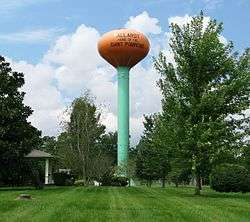
Pumpkin-shaped water tower in Allardt | |
 Location of Allardt, Tennessee | |
| Coordinates: 36°23′8″N 84°53′8″W / 36.38556°N 84.88556°WCoordinates: 36°23′8″N 84°53′8″W / 36.38556°N 84.88556°W[1] | |
| Country | United States |
| State | Tennessee |
| County | Fentress |
| Incorporated | 1964 |
| Named for | Frederick Allardt |
| Area | |
| • Total | 3.8 sq mi (9.8 km2) |
| • Land | 3.8 sq mi (9.8 km2) |
| • Water | 0.0 sq mi (0.0 km2) |
| Elevation | 1,677 ft (511 m) |
| Population (2010) | |
| • Total | 634 |
| • Density | 170/sq mi (65/km2) |
| Time zone | Central (CST) (UTC-6) |
| • Summer (DST) | CDT (UTC-5) |
| ZIP code | 38504 |
| Area code(s) | 931 |
| FIPS code | 47-00660[2] |
| GNIS feature ID | 1269300[3] |
Allardt is a city in Fentress County, Tennessee, United States. The population was 634 at the 2010 census.
History
After 1880, Frederick Allardt and Bruno Gernt brought a group of Germans from Michigan to settle in the area. The town was incorporated in 1964.[4]
Geography
According to the United States Census Bureau, the city has a total area of 3.8 square miles (9.8 km2), all of it land. The city is situated atop the western Cumberland Plateau in a relatively broad area surrounded by rugged hills. Tennessee State Route 52 passes roughly west-to-east through the city, connecting it with Jamestown to the northwest and Rugby to the east. State Route 296 intersects State Route 52 near the center of Allardt, and continues directly westward to U.S. Route 127.
Colditz Cove State Natural Area, best known for the 60-foot (18 m) Northrup Falls, lies just southeast of Allardt.[5] The Big South Fork National River and Recreation Area lies several miles to the northeast.
Demographics
| Historical population | |||
|---|---|---|---|
| Census | Pop. | %± | |
| 1970 | 610 | — | |
| 1980 | 654 | 7.2% | |
| 1990 | 609 | −6.9% | |
| 2000 | 642 | 5.4% | |
| 2010 | 634 | −1.2% | |
| Est. 2015 | 631 | [6] | −0.5% |
| Sources:[7][8] | |||
As of the census[2] of 2000, there were 642 people, 259 households, and 197 families residing in the city. The population density was 170.0 people per square mile (65.6/km²). There were 283 housing units at an average density of 74.9 per square mile (28.9/km²). The racial makeup of the city was 98.91% White, 0.16% Native American, 0.16% Asian, and 0.78% from two or more races. Hispanic or Latino of any race were 0.31% of the population.
There were 259 households out of which 31.3% had children under the age of 18 living with them, 64.5% were married couples living together, 9.7% had a female householder with no husband present, and 23.9% were non-families. 21.2% of all households were made up of individuals and 10.0% had someone living alone who was 65 years of age or older. The average household size was 2.48 and the average family size was 2.85.
In the city the population was spread out with 22.7% under the age of 18, 6.1% from 18 to 24, 26.0% from 25 to 44, 25.9% from 45 to 64, and 19.3% who were 65 years of age or older. The median age was 42 years. For every 100 females there were 92.8 males. For every 100 females age 18 and over, there were 87.2 males.
The median income for a household in the city was $34,412, and the median income for a family was $35,938. Males had a median income of $27,333 versus $18,929 for females. The per capita income for the city was $18,382. About 7.6% of families and 9.5% of the population were below the poverty line, including 16.2% of those under age 18 and 7.4% of those age 65 or over.
Arts and culture
Annual events
Every October the town hosts the Great Pumpkin Festival and Weigh-Off, which coincides with world-wide pumpkin weigh-off.[9]
Climate
The climate in this area is characterized by hot, humid summers and generally mild to cool winters. According to the Köppen Climate Classification system, Allardt has a humid subtropical climate, abbreviated "Cfa" on climate maps.[10]
References
| Wikimedia Commons has media related to Allardt, Tennessee. |
- ↑ "US Gazetteer files: 2010, 2000, and 1990". United States Census Bureau. 2011-02-12. Retrieved 2011-04-23.
- 1 2 "American FactFinder". United States Census Bureau. Archived from the original on September 11, 2013. Retrieved 2008-01-31.
- ↑ "US Board on Geographic Names". United States Geological Survey. 2007-10-25. Retrieved 2008-01-31.
- ↑ Larry L. Miller (October 2001). Tennessee place names. Indiana University Press. p. 5. ISBN 978-0-253-21478-2. Retrieved 21 November 2011.
- ↑ Carroll Van West, "Colditz Cove State Natural Area," Tennessee Encyclopedia of History and Culture. Accessed: 2 September 2015.
- ↑ "Annual Estimates of the Resident Population for Incorporated Places: April 1, 2010 to July 1, 2015". Retrieved July 2, 2016.
- ↑ "Census of Population and Housing: Decennial Censuses". United States Census Bureau. Retrieved 2012-03-04.
- ↑ "Incorporated Places and Minor Civil Divisions Datasets: Subcounty Resident Population Estimates: April 1, 2010 to July 1, 2012". Population Estimates. U.S. Census Bureau. Archived from the original on June 17, 2013. Retrieved 11 December 2013.
- ↑ "Great Pumpkin Festival and Weigh-Off". Tennessee Department of Tourist Development. 2011. Retrieved 20 November 2011.
- ↑ Climate Summary for Allardt, Tennessee
Municipalities and communities of Fentress County, Tennessee, United States | ||
|---|---|---|
| Cities | ||
| CDPs | ||
| Unincorporated communities | ||