Khanu Woralaksaburi District
| Khanu Woralaksaburi ขาณุวรลักษบุรี | |
|---|---|
| Amphoe | |
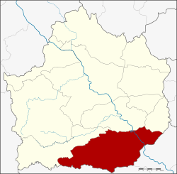 Amphoe location in Kamphaeng Phet Province | |
| Coordinates: 16°3′41″N 99°51′38″E / 16.06139°N 99.86056°ECoordinates: 16°3′41″N 99°51′38″E / 16.06139°N 99.86056°E | |
| Country |
|
| Province | Kamphaeng Phet |
| Seat | Saen To |
| Tambon | 11 |
| Muban | 143 |
| Area | |
| • Total | 1,143.1 km2 (441.4 sq mi) |
| Population (2014) | |
| • Total | 106,564 |
| • Density | 94.2/km2 (244/sq mi) |
| Time zone | THA (UTC+7) |
| Postal code | 62180 |
| Geocode | 6204 |
Khanu Woralaksaburi (Thai: ขาณุวรลักษบุรี) is a district (Amphoe) in the southern part of Kamphaeng Phet Province, central Thailand.
History
In 1987 history students from Silpakorn University surveyed in Khanu Woralaksaburi district area. They found stone axe, clay pot and beads of the Khao Kalon community. They estimated the age of the community to be around 5,000-1,000 years before historic era.
In Sukhothai Kingdom era, Mueang Saen To was an ancient city, contemporary of Mueang Trai Trueng, Phan, Khanathi, Nakhon Chum, Thep Nakhon and Chakangrao.
Tambon Saen To, Salok Bat, Bo Tham, Yang Sung and Rahan were separated from Khlong Khlung district and created to form a minor district (King Amphoe) named Khanu, which was renamed to Saen To in 1917.[1] The minor district was renamed to Khanu Woralaksaburi in 1939.[2] It was upgraded to a full district in 1948.[3]
Geography
Neighboring districts are (from the west clockwise) Pang Sila Thong, Khlong Khlung, Bueng Samakkhi of Kamphaeng Phet Province, Banphot Phisai, Lat Yao and Mae Wong of Nakhon Sawan Province.
Administration
Central administration
The district Khanu Woralaksaburi is subdivided into 11 subdistricts (Tambon), which are further subdivided into 143 administrative villages (Muban).
| No. | Name | Thai | Villages | Pop.[4] |
|---|---|---|---|---|
| 3. | Yang Sung | ยางสูง | 9 | 7,522 |
| 4. | Pa Phutsa | ป่าพุทรา | 16 | 9,869 |
| 5. | Saen To | แสนตอ | 7 | 9,330 |
| 6. | Salokbat | สลกบาตร | 7 | 11,994 |
| 7. | Bo Tham | บ่อถ้ำ | 18 | 13,118 |
| 8. | Don Taeng | ดอนแตง | 9 | 4,894 |
| 9. | Wang Chaphlu | วังชะพลู | 20 | 13,872 |
| 10. | Khong Phai | โค้งไผ่ | 13 | 6,461 |
| 11. | Pang Makha | ปางมะค่า | 24 | 17,441 |
| 12. | Wang Hamhae | วังหามแห | 12 | 7,794 |
| 13. | Ko Tan | เกาะตาล | 8 | 4,269 |
Missing numbers are district which now form Bueng Samakkhi district.
Local administration
There is one town (Thesaban Mueang) in the district:
- Pang Makha (Thai: เทศบาลเมืองปางมะค่า) consisting of the complete subdistrict Pang Makha.
There are 2 subdistrict municipalities (Thesaban Tambon) in the district:
- Khanu Woralaksaburi (Thai: เทศบาลตำบลขาณุวรลักษบุรี) consisting of parts of the subdistricts Yang Sung, Pa Phutsa and Saen To.
- Salokbat (Thai: เทศบาลตำบลสลกบาตร) consisting of parts of the subdistrict Salokbat.
There are 10 subdistrict administrative organizations (SAO) in the district:
- Yang Sung (Thai: องค์การบริหารส่วนตำบลยางสูง) consisting of parts of the subdistrict Yang Sung.
- Pa Phutsa (Thai: องค์การบริหารส่วนตำบลป่าพุทรา) consisting of parts of the subdistrict Pa Phutsa.
- Saen To (Thai: องค์การบริหารส่วนตำบลแสนตอ) consisting of parts of the subdistrict Saen To.
- Salokbat (Thai: องค์การบริหารส่วนตำบลสลกบาตร) consisting of parts of the subdistrict Salokbat.
- Bo Tham (Thai: องค์การบริหารส่วนตำบลบ่อถ้ำ) consisting of the complete subdistrict Bo Tham.
- Don Taeng (Thai: องค์การบริหารส่วนตำบลดอนแตง) consisting of the complete subdistrict Don Taeng.
- Wang Chaphlu (Thai: องค์การบริหารส่วนตำบลวังชะพลู) consisting of the complete subdistrict Wang Chaphlu.
- Khong Phai (Thai: องค์การบริหารส่วนตำบลโค้งไผ่) consisting of the complete subdistrict Khong Phai.
- Wang Hamhae (Thai: องค์การบริหารส่วนตำบลวังหามแห) consisting of the complete subdistrict Wang Hamhae.
- Ko Tan (Thai: องค์การบริหารส่วนตำบลเกาะตาล) consisting of the complete subdistrict Ko Tan.
References
- ↑ "ประกาศกระทรวงมหาดไทย เรื่อง เปลี่ยนชื่ออำเภอ" (PDF). Royal Gazette (in Thai). 34 (0 ก): 40–68. 1917-04-29.
- ↑ พระราชกฤษฎีกาเปลี่ยนนามอำเภอ กิ่งอำเภอ และตำบลบางแห่ง พุทธศักราช ๒๔๘๒ (PDF). Royal Gazette (in Thai). 56 (0 ก): 354–364. April 17, 1939.
- ↑ "ประกาศสำนักนายกรัฐมนตรี เรื่อง ยกฐานะกิ่งอำเภอขาณุวรลักษณบุรี อำเภอคลองขลุงจังหวัดกำแพงเพชร ขึ้นเป็นอำเภอ" (PDF). Royal Gazette (in Thai). 65 (66 ง): 3649. 1948-11-16.
- ↑ "Population statistics 2014" (in Thai). Department of Provincial Administration. Retrieved 2015-08-31.