Apagado
| Apagado (Hualiaque) | |
|---|---|
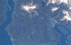 The volcano is visible in the lower center of this NASA image. | |
| Highest point | |
| Elevation | 1,210 m (3,970 ft) |
| Coordinates | 41°53′0″S 72°35′0″W / 41.88333°S 72.58333°WCoordinates: 41°53′0″S 72°35′0″W / 41.88333°S 72.58333°W |
| Geography | |
| Location | Los Lagos Region, Chile |
| Parent range | Andes |
| Geology | |
| Mountain type | Pyroclastic cone |
| Last eruption | 590 BCE |
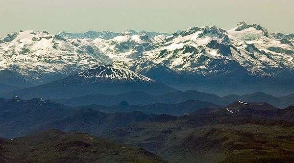
Apagado (Spanish for Extinct, also known as Hualiaque) is a pyroclastic cone with scattered vegetation cover. It has an approximately 400 m (1,312 ft)-wide crater and a base diameter of approximately 2 km (1 mi). The volcano is located in Chile's Los Lagos Region, and lies 13 km (8 mi) west of the Hornopirén Volcano and southwest of Yate Volcano on a peninsula that borders the Reloncaví Estuary, Reloncaví Sound and Gulf of Ancud. Apagado has a nearly intact summit crater.
Hornopirén and Apagado. Hornopirén is the wide, cone-shaped mountain with flow patterns in the snow on its summit, while Apagado is the small, brownish cone with the wide crater on the bottom right hand side. It has a curved snow border on the left edge of its crater rim.
See also
References
External links
- SI Google Earth Placemarks - Smithsonian Institution Global Volcanism Program: download placemarks with SI Holocene volcano-data.
This article is issued from Wikipedia - version of the 6/5/2016. The text is available under the Creative Commons Attribution/Share Alike but additional terms may apply for the media files.