Carrán-Los Venados
| Carrán-Los Venados | |
|---|---|
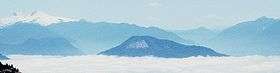 Cerro Los Guindos (center) as seen from south; Mocho-Choshuenco volcano in left background | |
| Highest point | |
| Elevation | 1,114 m (3,655 ft) |
| Coordinates | 40°18′29″S 72°04′12″W / 40.308°S 72.07°W (highest point) |
| Geography | |
| Location | Chile |
| Geology | |
| Mountain type | Pyroclastic cones, maars |
| Volcanic arc/belt | Southern Volcanic Zone |
| Last eruption | April to May 1979 |
Carrán-Los Venados (Spanish pronunciation: [kaˈran los βeˈnaðos]) is a volcanic group of scoria cones, maars and small stratovolcanoes in southern Chile, southeast of Ranco Lake. The highest cone is Los Guindos (Spanish for "The Cherry Trees), which is a small stratovolcano with an elevation of 1,114 metres (3,655 ft). The volcanic group has recorded eruptions from 1955 and 1979. Located south of Maihue Lake and north Puyehue Volcano Carrán-Los Venados group is placed at the intersection of several faults on the thin crust (~30 km) of southern Chile, among them Liquiñe-Ofqui and Futrono Fault.
Volcanoes
- Carrán - a waterfilled maar, erupted in 1955 (also called "Nilahue")
- Mirador - a cinder cone, erupted in 1979
- Pocura - a water filled maar, unknown date of eruption
- Riñinahue - a non-waterfilled maar, erupted in 1907
- Volcanes Los Venados - the western and southern most group of volcanoes of Carrán-Los Venados group, unknown dates of eruption
- Los Guindos - the tallest of the group, an extinct small stratocone
See also
References
Müller, G. and Veyl, G., 1957. The birth of Nilahue, a new maar type volcano at Rininahue, Chile, 20th International Geological Congress, Mexico, pp. 375–396.