Licancabur
| Licancabur (volcano) | |
|---|---|
 Summit of the Licancabur volcano | |
| Highest point | |
| Elevation | 5,916 m (19,409 ft) [1] |
| Prominence | 1,320 metres (4,330 ft) |
| Coordinates | 22°50′01″S 67°52′58″W / 22.83361°S 67.88278°WCoordinates: 22°50′01″S 67°52′58″W / 22.83361°S 67.88278°W |
| Geography | |
| Location | Chile / Bolivia |
| Parent range | Andes |
| Geology | |
| Age of rock | Holocene |
| Mountain type | Stratovolcano |
| Last eruption | Unknown |
| Climbing | |
| First ascent | Inca, pre-Columbian |
| Easiest route | Hike |
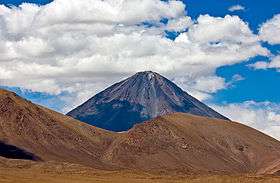
Licancabur is a stratovolcano on the border between Bolivia and Chile, south of the Sairecabur volcano and with the Juriques volcano to the east. It is part of the Andean Central Volcanic Zone of the Andes, and it forms a 5,916 metres (19,409 ft) high prominent cone. A summit crater with a diametre of 400 metres (1,300 ft) caps off the volcano, a crater lake named Licancabur Lake lies in the crater and is among the highest lakes in the world. Three stages of lava flows emanate from the volcano, which is constructed on Pleistocene ignimbrites.
Licancabur has been active in the Holocene, after the ice ages. No historical eruptions of the volcano are known, but lava flows extending into Laguna Verde have been dated 13,240 ± 100 BP ago. The volcano has principally erupted andesite with minor amounts of dacite and basaltic andesite.
The climate on the volcano is cold, dry and very sunny, resulting in a high amount of ultraviolet radiation. The volcano is not covered by glaciers, but vegetation like cushion plants and shrubs can be found lower on its slopes. Chinchillas were formerly hunted on the volcano.
The volcano is considered a holy mountain by Atacameno people, and is considered to have a relationship to Cerro Quimal. Archeological sites have been found both on its slopes and in the summit crater; the summit crater site may have served as a prehistorical watchtower.
Naming
The word Licancabur comes from a Kunza name used by the Atacameño people to refer to the volcano: lican (people or pueblo) and cábur (mountain), thus meaning "Mountain of the People".[2]
Geography and geology
General setting
The Andean Volcanic Belt is generally subdivided into three main volcanic zones, the Northern Volcanic Zone 2° N-5° S, the Central Volcanic Zone 16° S-28° S and the Southern Volcanic Zone 33° S-46° S. Active volcanism occurs where the Nazca Plate subducts beneath the South America Plate. They are separated by zones where subduction does occur as well, but is much shallower and where there is no present day volcanism.[3] The existence of these regions of shallower subduction has been variously attributed to a high speed of the plate collision, young age of the subducting oceanic lithosphere and the curvature of the subducting plate. The most plausible theory is that variation of the buoyancy of the subducting plate creates flat subduction zones.[4] For example, the Cocos Ridge, Juan Fernandez Ridge and the Nazca Ridge are associated with such volcanic gaps where they collide with the trench.[5] The subduction of spreading ridges can also diminish volcanism, as observed for the Chile Rise farther south. Potentially, the buoyancy of these crustal structures hampers their subduction and reduces the supply of water to the mantle,[6] which induces the formation of melts.[7]
Not all volcanism in Chile is related to the subduction of the Nazca Plate; the Chile Ridge displays submarine volcanism,[8] and volcanism in the Austral Volcanic Zone is triggered by the subduction of the Antarctic Plate beneath the South America Plate.[9] Overall, 198 volcanoes have been identified in South America by the Holocene volcano list of the Global Volcanism Program.[10]
Local

Licancabur is part of the Central Volcanic Zone, at the western margin of the Altiplano.[11] Among the active volcanoes of the region are Putana (end of the 19th century), Llullaillaco (1868) and Lascar (1993; As of March 2016, the last eruption took place in October 2015[12]).[13] Other stratovolcanoes are Tacora, Nevados de Payachata, Isluga, Tata Sabaya, Ollague, Tocorpuri, Sairecabur and Socompa.[14] Overall, more than 1100 volcanic centres are found in the Central Volcanic Zone, many of them are older than the Pleistocene as the aridity of the climate in most of the area prevented substantial erosion.[8] Starting in the Miocene the area around Licancabur was also the site of major ignimbrite-forming eruptions.[15] Llano de Chajnantor southeast of Licancabur is the site of several observatories, the Llano de Chajnantor Observatory.[16]
Licancabur is located just south of Sairecabur, a group of volcanoes which rise to altitudes of 5,800 metres (19,000 ft) and appear to be the source of recent volcanic activity. East of Licancabur lies the companion volcano Juriques.[17] This volcano is 5,710 metres (18,730 ft) high and features a very large (1.5 kilometres (0.93 mi)[1]) and deep crater. It is considered to be a parasitic cone.[13] West-east alignments of volcanoes like Licancabur and Juriques are common in the region due to tectonic influence.[18] Araral, Cerro Cabana, Cerro Canapa, Cerros de Tocorpuri, Cerro Linzor, Inacaliri, Inca, Jardin, Putana, Volcan Tatio and Zapaleri are other volcanoes in the neighbourhood of Licancabur.[19] 19 kilometres (12 mi) farther southeast, the volcanic chain continues with Tocol and the Purico Complex and continues farther, including to 6,723 metres (22,057 ft) high Llullaillaco volcano. Volcanoes in the Puna de Atacama starting from the Pliocene formed on Tertiary ignimbrites formed by dacite, liparite and rhyolite. These rocks have a light colour due to the rhyolite.[17] Licancabur is constructed on top of the 1.35 million years old Purico ignimbrite,[20] the La Pacana ignimbrite and the Chaxas ignimbrites.[11] The Chaxas ignimbrite was erupted 1.09 ± 0.56 million years ago.[21]
Licancabur is a 5,916 metres (19,409 ft) high,[1] prominent cone with a symmetric appearance.[16] The cone rises 1,500 metres (4,900 ft) above the surrounding terrain and with a base diametre of 9 cubic kilometres (2.2 cu mi) it has a total volume of 35 cubic kilometres (8.4 cu mi).[20] The top of the mountain is formed by a 400 metres (1,300 ft) wide crater. The slopes of the volcano are fairly steep, around 30°.[1] The volcano has erupted blocky lava flows with thicknesses ranging 50–10 metres (164–33 ft); younger lava flows are thinner.[22] Young lava flows on the western sides of the volcano reach lengths of 6 kilometres (3.7 mi) and older ones 15 kilometres (9.3 mi).[1] Some old lava flows reach to the Laguna Verde.[11] 12 kilometres (7.5 mi) long pyroclastic flow deposits have also been found.[1] The eastern and western flanks of the volcano have different appearances, since the volcano formed on a basement which dips towards the Salar de Atacama. West of the volcano there are deposits stemming from debris avalanche activity,[20] including blocks 10 metres (33 ft) wide.[22] The frontier between Bolivia and Chile runs across the mountain, as defined by the Treaty of Peace and Friendship (1904) between Bolivia and Chile.[23]
.jpg)
An elliptical lake was identified in the crater of Licancabur and 90 metres (300 ft) beneath the crater rim, with a length of 85 metres (280 ft) and a depth of 1.5–3.0 metres (5–10 ft).[24][25] This crater lake is among the highest lakes in the world,[1] it is fed by snowfall.[26] Based on a relative lack of salt deposits, researchers in 1955 postulated that the lake spilled over the southwestern side of the crater when the climate was wetter, through a notch 9.1 metres (30 ft) beneath the crater rim. Nowadays excess water leaves through seepage, keeping salt levels low.[27] There are other lakes at such altitudes of the Andes, usually they are frozen.[26]
The slopes of Licancabur are unstable and prone to rock falls. Some of this instability may be because of earthquakes, snow, wind,[13] or geothermal effects resulting in thermal stress.[26] This instability frustrated an attempt during the 1920s by an engineer at Chuquicamata to climb the mountain.[28]
Composition
Licancabur has erupted principally andesite, but basaltic andesite and dacite are also found.[29] The rocks have dark and grey colours.[30] Basaltic andesite was found in the older lavas and dacite in the more recent ones.[31] The rocks have a seriate texture,[32] but the groundmass is hyalopilitic.[29] Phenocrysts include amphibole, clinopyroxene,[32] hornblende,[29] orthopyroxene, plagioclase and titanomagnetite;[32] in andesite also olivine,[29] in dacites also biotite.[33] Plagioclase is the most common of these.[20] Overall the amount of phenocrysts in Licancabur's rocks is smaller than in other volcanoes of the Central Volcanic Zone such as Lascar.[32]
Clots of crystals with diametres 2–3 millimetres (0.079–0.118 in) or larger are also found. They also contain glass, microliths and phenocrysts and have similar compositions to phenocrysts.[34] These clots probably formed from the aggregation of phenocrysts and their subsequent growth; some phenocrysts in the rocks formed when the clots broke apart again.[35]
The temperature of pre-eruption magmas of Licancabur have been determined composition of the rocks; they range 860–1,060 ± 20 °C (1,580–1,940 ± 36 °F) for andesite and 930 ± 20 °C (1,706 ± 36 °F). Isotope ratios are typical for volcanoes of the Central Volcanic Zone. There are differences in the elemental composition of andesites and dacites,[33] the latter resemble adakites more than the former. Antisana in the Northern Volcanic Zone and El Negrillar in the Central Volcanic Zone are other two centres which have erupted adakites or adakite-like lavas.[36]
Based on their composition, it is assumed that the magma at Licancabur formed from the partial melting of the oceanic crust subducted at the Peru-Chile Trench after metamorphosis. This magma melted part of the mantle wedge above the subducting plate and mixed with the melt products. Further contamination by crustal Tonalite-Trondhjemite-Granodiorite like rocks from the Archean, crystal fractionation and magma mixing farther up in the crust then yielded the Licancabur magmas.[37] The younger lavas may have formed from the mixing of dacite with the magmas that formed the older lavas.[31] Some inclusions in Licancabur rocks seem to come from wall rocks of the magma chamber.[38]
Xenoliths containing gabbro are also found.[32] Unlike a number of neighbouring volcanoes such as Saciel at Sairecabur farther north and Tocol farther south, there appear to be no deposits of sulfur on the volcano.[39]
Climate and life

The climate in the region has been arid since the Tertiary.[15] In the area of Licancabur, it is dominated by year-round high pressure caused by the South Pacific High. This causes a very sunny climate in the area.[40] The energy absorbed by the Earth for lack of moisture is mostly consumed by winds, in the area of Llano de Chajnantor these winds reach their maximum strength generally during daytime and come usually from the west, except in summer when wind direction is more variable.[41] Because of the tropical location where the ozone layer is thinner and high altitude, the area also receives a large amount of ultraviolet radiation. The highest amounts of ultraviolet radiation in the world were reported from Licancabur, although concerns about such high irradiation values causing measurement artifacts exist.[42]
Air temperatures obtained at the lake range 5 – −40 °C (41 – −40 °F).[43] According to observers in 1955, temperatures at the Licancabur summit were always beneath freezing, sometimes descending to less than −18 °C (0 °F).[26] At Llano de Chajnantor southeast of Licancabur, weather records indicate that temperatures usually vary between maxima of −15–15 °C (5–59 °F).[41]
Average precipitation on Licancabur is estimated to be about 360 millimetres (14 in) per year.[44] Snowfall at Licancabur probably exceeded 4,300 millimetres (14 ft) in 1955.[27] Snowfall has been recorded to occur at Llano de Chajnantor when in summer easterly winds transport moisture from the Amazon to the area.[41] Licancabur has no persistent snow cover; snow deposited by storms usually disappears within a few days.[39] In sheltered areas, snow can also last months.[41] At Licancabur, the present day snowline has been estimated to be 6,190 metres (20,310 ft) high.[45]
The vegetation at lower altitudes is typical for a high tropical desert climate.[46] Three biozones have been described in the region, an Andean zone 3,850–4,200 metres (12,630–13,780 ft) that features cushion plants and tussock grass, a Puna zone 3,100–3,800 metres (10,200–12,500 ft) and a pre-Puna 2,700–3,100 metres (8,900–10,200 ft) with thorny shrubs. In the oases and river valleys of the depression between the pre-Cordillera and the main Andes shrubs like Atriplex grow, the surrounding dry Atacama Desert is mostly devoid of plant life.[47]
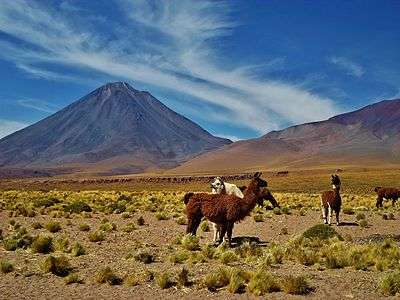
Meltwater from snow supports more life at Licancabur than is normal for similar mountains, and at higher altitudes as well. Grass, tola bushes, butterflies, flies and lizards are found to 4,900 metres (16,000 ft). Life farther down the mountain may be supported by the fertilizing effect of the dusts from the volcanic rocks.[23] Polylepis incana may have been more frequent at Licancabur during wetter times, now it is more common in Bolivia.[48] Chinchillas were found up to 4,900 metres (16,000 ft) in 1955. The upper parts of the mountain had been avoided by hunters, and after some attempts in the 1920s at high altitude the practice of chinchilla hunting disappeared from the area.[49] Today Licancabur is located in the Eduardo Avaroa Andean Fauna National Reserve.[50]
Eruptive history
The volcano was constructed in three units, all of which feature lava flows although the last one also includes pyroclastic deposits. The bulk of the cone is formed by the second unit.[11] The eruption of the second unit was preceded by the injection of basic magma into the magma chamber.[51] The oldest flows crop out on the western and northern side of the volcano, they are partly covered by more recent flows from Licancabur and by flows from Sairecabur.[20] These flows appear to be of preglacial age.[22] The older lavas have compositions comparable to shoshonite and old Sairecabur lavas, they also tend to be more basic than the recent lavas.[31] Explosive activity left pyroclastic deposits on the volcano, but was not strong.[22] Licancabur formed principally after the late glacial, between 12,000 and 10,000 years ago.[11] Flank lava flows are the youngest feature on Licancabur. Neighbouring Juriques is of Pleistocene age.[1]
Licancabur's lava flows were not affected by glaciation and some even maintain levees and ridges.[20] Some lava flows that reach Laguna Verde have been radiocarbon dated to be 13,240 ± 100 BP old.[24] The volcano has had no eruptions during historical time.[17] The crater lake may be kept unfrozen by geothermal heat.[26]
Human effects
Despite being lower than many neighbouring mountains, Licancabur does stand out among the volcanoes in the region and receives disproportionate recognition.[52] The Atacameno people worshipped the mountain,[39] other high mountains are still considered sacred. The mountain was considered divine and attempts to climb it were discouraged and sometimes countered with force, the climbing supposedly leading to calamities.[53] It is said that Licancabur would punish people who climbed the mountain,[54] and that it was married to Quimal in the Cordillera Domeyko; during the summer solstice and the winter equinox these two mountains shadow each other.[55] This event is considered to be the copulation between the two mountains, which fertilizes the earth, and is one of the most important myths in the area.[56] Licancabur is usually considered male,[57] and a mountain of fire unlike say San Pedro which is a mountain of water.[58] The 1953 Antofagasta earthquake was considered to be divine retribution for an attempt to climb the mountain in that year.[59] Legend has it that a golden object, most commonly a guanaco, was offered for tribute in the summit crater.[53] Human sacrifices have also been reported from Licancabur.[60]
Climbers in 1953 found three buildings open to the side on Licancabur. These buildings were built in the pirca style where stones are fit to each other without mortar.[25] A pile of wood was also found between two of the buildings.[61] This structure has been described as two dwellings and a fireplace.[54] In addition, wood was scattered around the crater.[25] Given the wide view from the summit, which includes Calama and pass routes coming from Argentina, Licancabur may have worked as a watchtower for the Atacamenos.[62] The function as a watchtower may have been coordinated with that of other fortresses in the area such as Lasana and Turi,[63] as well as a settlement mentioned in 1955 records at Quebrada de Chaxas northwest of the volcano.[48] The settlement of Licancabur is formed by a central courtyard and surrounding buildings. Ceramics found there resemble these of Pukará de Quitor and Toconao Oriente.[54] A tambo reportedly existed at Licancabur.[64]

Other archeological findings on Andean mountains were made on Acamarachi and Pular, where ceremonial platforms were found, and on Cerro Colorado, Juriques, Llullaillaco, Miniques and Quimal. These archeological findings include sites named pirca and firewood. Some of these sites may have been a signaling system.[65] Many of these sites were used during Inka times, however on Quimal artifacts and reports of use during Spanish time have been found.[66] Aconcagua, Coropuna, Chachani, El Plomo, El Toro, Llullaillaco, Mercedario amd Picchu Picchu are other mountains which are known for hosting Inka sanctuaries.[67]
The area at Licancabur was first settled by Atacameno people, presumably because of the water found in local canyons as the area is quite dry. Later the Inca under Yawar Waqaq and in the early 16th century the Spaniards came to the region. Yareta and chinchilla skins were sought for by the latter two.[39]

Unlike a number of neighbouring mountains, Licancabur is difficult to climb especially in its upper parts, as the slopes are steep and the ground loose and prone to landslides.[68] Rumours about there being a "staircase", later probably obliterated by landsliding and rockfalls, are mentioned in 1955.[48] In 1953, a road led up to 4,300 metres (14,000 ft) altitude.[53] Excluding previous unrecorded climbings, the first recorded ascent of the mountain was in 1884 by Severo Titicocha, who was accompanied by Juan Santelices, a delegate of the Chilean government, during another ascent in 1886.[69]
Gallery
-

Panorama of Licancabur volcano.[1]
-

Licancabur, on the left, is much younger than its smaller neighbour Juriques.[2]
-
An icy forest of penitentes cluster in the foreground.[3]
-

Licancabur and Laguna Verde.
- ^ "Spatterings of Stars and Snow". Picture of the Week. European Southern Observatory. Retrieved 26 February 2015.
- ^ "Alien Atacama". ESO Picture of the Week. Retrieved 1 August 2014.
- ^ "Iconic, Conical Licancabur Watches Over Chajnantor". ESO Picture of the Week. Retrieved 3 October 2012.
See also
- List of volcanoes in Bolivia
- List of volcanoes in Chile
- List of andean peaks with known pre-columbian ascents
- Juriques
- Sairecabur
- Purico Complex
- Llano de Chajnantor Observatory
References
- 1 2 3 4 5 6 7 8 "Licancabur". Global Volcanism Program. Smithsonian Institution.
- ↑ Rudolph 1955, pp. 153-154.
- ↑ Wörner, G.; Harmon, R. S.; Davidson, J.; Moorbath, S.; Turner, D. L.; McMillan, N.; Nyes, C.; Lopez-Escobar, L.; Moreno, H. (September 1988). "The Nevados de Payachata volcanic region (18°S/69°W, N. Chile)". Bulletin of Volcanology. 50 (5): 287–289. doi:10.1007/BF01073587.
- ↑ Gutscher, Marc-André (April 2002). "Andean subduction styles and their effect on thermal structure and interplate coupling". Journal of South American Earth Sciences. 15 (1): 6–7. doi:10.1016/S0895-9811(02)00002-0.
- ↑ Nur & Ben-Avraham 1981, p. 730.
- ↑ Nur & Ben-Avraham 1981, p. 734.
- ↑ Nur & Ben-Avraham 1981, p. 738.
- 1 2 Teresa Moreno (Ph. D.); Wes Gibbons (2007). The Geology of Chile. Geological Society of London. p. 147. ISBN 978-1-86239-220-5.
- ↑ Stern, C. R.; Kilian, Rolf (1996). "Role of the subducted slab, mantle wedge and continental crust in the generation of adakites from the Andean Austral Volcanic Zone". Contributions to Mineralogy and Petrology. 123 (3): 264. doi:10.1007/s004100050155. ISSN 0010-7999.
- ↑ "The South America Region". Global Volcanism Program. Smithsonian Institution. Archived from the original on 22 September 2016.
- 1 2 3 4 5 Figueroa, Déruelle & Demaiffe 2009, p. 311.
- ↑ "Lascar". Global Volcanism Program. Smithsonian Institution. Archived from the original on 4 March 2016. Retrieved 19 November 2016.
- 1 2 3 Rudolph 1955, p. 161.
- ↑ H Leyrit; C Montenat (8 August 2000). Volcaniclastic Rocks, from Magmas to Sediments. CRC Press. p. 5. ISBN 978-90-5699-278-1.
- 1 2 de Silva 1989, p. 94.
- 1 2 Giovanelli et al. 2001, p. 791.
- 1 2 3 Rudolph 1955, p. 160.
- ↑ Klaus-Joachim Reutter; Ekkehard Scheuber; Peter Wigger (6 December 2012). Tectonics of the Southern Central Andes: Structure and Evolution of an Active Continental Margin. Springer Science & Business Media. p. 109. ISBN 978-3-642-77353-2.
- ↑ Rudolph 1951, p. 112.
- 1 2 3 4 5 6 Figueroa & Déruelle 1996, p. 563.
- ↑ de Silva 1989, p. 102.
- 1 2 3 4 Figueroa 1997, p. 322.
- 1 2 Rudolph 1955, p. 170.
- 1 2 Cabrol, Grin & Hock 2007, p. 4.
- 1 2 3 Rudolph 1955, p. 156.
- 1 2 3 4 5 Rudolph 1955, p. 162.
- 1 2 Rudolph 1955, p. 164.
- ↑ Rudolph 1951, p. 113.
- 1 2 3 4 Figueroa & Deruelle 1999, p. 240.
- ↑ Figueroa 1997, p. 324.
- 1 2 3 Figueroa & Déruelle 1996, p. 566.
- 1 2 3 4 5 Figueroa, Déruelle & Demaiffe 2009, p. 312.
- 1 2 Figueroa, Déruelle & Demaiffe 2009, p. 313.
- ↑ Figueroa & Deruelle 1999, p. 241.
- ↑ Figueroa & Deruelle 1999, p. 243.
- ↑ Figueroa, Déruelle & Demaiffe 2009, p. 314.
- ↑ Figueroa, Déruelle & Demaiffe 2009, p. 317.
- ↑ Figueroa 1997, p. 326.
- 1 2 3 4 Rudolph 1955, p. 153.
- ↑ Giovanelli et al. 2001, p. 792.
- 1 2 3 4 Giovanelli et al. 2001, p. 793.
- ↑ Albarracín, Virginia Helena; Gärtner, Wolfgang; Farias, María Eugenia (January 2016). "Forged Under the Sun: Life and Art of Extremophiles from Andean Lakes". Photochemistry and Photobiology. 92 (1): 14–28. doi:10.1111/php.12555.
- ↑ Cabrol, Grin & Hock 2007, p. 5.
- ↑ Sepúlveda Rivera, Isabel; Molina Otárola, Raúl; Delgado-Serrano, María del Mar; Guerrero Ginel, José Emilio (December 2015). "AGUAS, RIEGO Y CULTIVOS: CAMBIOS Y PERMANENCIAS EN LOS AYLLUS DE SAN PEDRO DE ATACAMA". Estudios atacameños (in Spanish) (51): 189. doi:10.4067/S0718-10432015000200012.
- ↑ Ram Bali Singh (1992). Dynamics of Mountain Geosystems. APH Publishing. p. 165. ISBN 978-81-7024-472-1.
- ↑ Cavieres, Lohengrin A.; Arroyo, Mary T.K.; Posadas, Paula; Marticorena, Clodomiro; Matthei, Oscar; Rodríguez, Roberto; Squeo, Francisco A.; Arancio, Gina (2002). "Identification of priority areas for conservation in an arid zone: application of parsimony analysis of endemicity in the vascular flora of the Antofagasta region, northern Chile". Biodiversity and Conservation. 11 (7): 1303. doi:10.1023/A:1016001714358.
- 1 2 3 Rudolph 1955, p. 171.
- ↑ Rudolph 1955, p. 169.
- ↑ Villarroel, Javier A. Velasco; Peñaranda, Edgar S. (2000-01-01). "Generación de energía eléctrica a partir de vapor del pozo geotérmico apacheta AP-XI". Revista Metalúrgica UTO (in Spanish).
- ↑ Figueroa 1997, p. 325.
- ↑ Rudolph 1955, p. 151.
- 1 2 3 Rudolph 1955, p. 154.
- 1 2 3 Le Paige 1978, p. 37.
- ↑ Le Paige 1978, p. 40.
- ↑ Contreras, Ernesto (1994-01-01). "Cultura y naturaleza en la cuenca del Salar de Atacama". Estudios Atacameños. Arqueología y antropología surandinas (in Spanish). 0 (11): 183. ISSN 0718-1043.
- ↑ Moraga, Anita Carrasco (November 2010). "A Sacred Mountain and the Art of "Impression Management"". Mountain Research and Development. 30 (4): 394. doi:10.1659/MRD-JOURNAL-D-09-00065.1.
- ↑ Castro, Victoria; Aldunate, Carlos (February 2003). "Sacred Mountains in the Highlands of the South-Central Andes". Mountain Research and Development. 23 (1): 73. doi:10.1659/0276-4741(2003)023[0073:SMITHO]2.0.CO;2.
- ↑ Rudolph 1955, p. 156,159.
- ↑ Bouysse-Cassagne, Thérèse; Chacama R, Juan (2012). "PARTICIÓN COLONIAL DEL TERRITORIO, CULTOS FUNERARIOS Y MEMORIA ANCESTRAL EN CARANGAS Y PRECORDILLERA DE ARICA (SIGLOS XVI-XVII)". Chungará (Arica) (in Spanish). 44 (4): 669–689. doi:10.4067/S0717-73562012000400009.
- ↑ Rudolph 1955, p. 157.
- ↑ Rudolph 1955, pp. 165-166.
- ↑ Rudolph 1955, p. 167.
- ↑ Uribe Rodríguez, Mauricio (July 2004). "EL INKA Y EL PODER COMO PROBLEMAS DE LA ARQUEOLOGÍA DEL NORTE GRANDE DE CHILE". Chungará (Arica) (in Spanish). 36 (2). doi:10.4067/S0717-73562004000200006.
- ↑ Le Paige 1978, pp. 40-41.
- ↑ Le Paige 1978, pp. 47-48.
- ↑ Moyano, Ricardo (2009). "El adoratorio del cerro El Potro: Arqueología de alta montaña en la cordillera de Copiapó, norte de Chile". Estudios atacameños (in Spanish) (38). doi:10.4067/S0718-10432009000200004.
- ↑ Rudolph 1955, p. 152.
- ↑ Rudolph 1955, p. 159.
Sources
- Cabrol, Nathalie A.; Grin, Edmond A.; Hock, Andrew N. (2007-01-01). "Mitigation of environmental extremes as a possible indicator of extended habitat sustainability for lakes on early Mars". 6694. doi:10.1117/12.731506.
- Figueroa, O.A.; Déruelle, B. (1996-01-01). "Licancabur, an andesitic volcano of the South-central Andes".
- Figueroa, Oscar (October 1997). "El volcán Licancabur -22o56'S, 67o53'W, segunda región de Antofagasta-: Geología, petrografía y mineralogía" (PDF). biblioteca.sernageomin.cl (in Spanish). Antofagasta: 8th Chilean Geological Congress. Retrieved 17 November 2016.
- Figueroa, Oscar; Deruelle, Bernard (October 1999). "ORIGIN OF CRYSTAL CLOTS AND THEIR ORTHOPYROXENE- TITANOMAGNETITE SYMPLECTITES IN LAVAS FROM THE LICANCABUR VOLCANO, SOUTH-CENTRAL ANDES" (PDF). Fourth ISAG: 240–244. Retrieved 17 November 2016.
- Figueroa, Oscar; Déruelle, Bernard; Demaiffe, Daniel (April 2009). "Genesis of adakite-like lavas of Licancabur volcano (Chile—Bolivia, Central Andes)". Comptes Rendus Geoscience. 341 (4): 310–318. doi:10.1016/j.crte.2008.11.008.
- Giovanelli, Riccardo; Darling, Jeremy; Sarazin, Marc; Yu, Jennifer; Harvey, Paul; Henderson, Charles; William Hoffman; Keller, Luke; Barry, Don (2001-01-01). "The Optical/Infrared Astronomical Quality of High Atacama Sites. I. Preliminary Results of Optical Seeing". Publications of the Astronomical Society of the Pacific. 113 (785): 789. doi:10.1086/322135. ISSN 1538-3873.
- Le Paige, Gustavo (1978-01-01). "Vestigios arqueológicos incaicos en las cumbres de la zona atacameña". Estudios Atacameños (in Spanish) (6): 36–52.
- Nur, Amos; Ben-Avraham, Zvi (1981). "Volcanic gaps and the consumption of aseismic ridges in South America". 154: 729–740. doi:10.1130/MEM154-p729. ISSN 0072-1069.
- Rudolph, William E. (January 1951). "Chuquicamata Twenty Years Later". Geographical Review. 41 (1). doi:10.2307/211310.
- Rudolph, William E. (April 1955). "Licancabur: Mountain of the Atacamenos". Geographical Review. 45 (2): 151. doi:10.2307/212227 – via http://www.estudios-atacamenos.ucn.cl/revista/pdf/numero06/EA6-3.pdf.
- de Silva, S.L. (May 1989). "Geochronology and stratigraphy of the ignimbrites from the 21°30′S to 23°30′S portion of the Central Andes of northern Chile". Journal of Volcanology and Geothermal Research. 37 (2): 93–131. doi:10.1016/0377-0273(89)90065-6.
General sources
- Biggar, John (2005). Andes: a Guide for Climbers (3rd ed.). Castle Douglas: Andes. pp. 284–285. ISBN 0-9536087-2-7.
- De Silva, Shanaka L.; Francis, Peter (1991). Volcanoes of the Central Andes. Berlin: Springer-Verlag. pp. 81–82. ISBN 3-540-53706-6.
- NASA Licancabur Expedition: Exploring the Highest Lakes on Earth
- Gonzalez-Ferran, Oscar (1994). Volcanes de Chile (in Spanish) (1 ed.). Santiago, Chile: Instituto geografico militar. ISBN 956-202-054-1.
External links
| Wikimedia Commons has media related to Licancabur. |
- Licancabur, tour 2003
- Lake Licancabur
- Licancabur, cerca de Marte - Mercuria Calama article - (In Spanish).