Apple Creek Township, Cape Girardeau County, Missouri
| Apple Creek Township | |
|---|---|
| Township | |
 | |
| Coordinates: 37°31′32″N 089°45′35″W / 37.52556°N 89.75972°WCoordinates: 37°31′32″N 089°45′35″W / 37.52556°N 89.75972°W | |
| Country | United States |
| State | Missouri |
| County | Cape Girardeau |
| Area | |
| • Total | 83.38 sq mi (215.96 km2) |
| • Land | 83.34 sq mi (215.84 km2) |
| • Water | 0.04 sq mi (0.12 km2) 0.06% |
| Elevation[1] | 577 ft (176 m) |
| Population (2000) | |
| • Total | 1,960 |
| • Density | 23.5/sq mi (9.1/km2) |
| FIPS code | 29-01450[2] |
| GNIS feature ID | 0766395 |
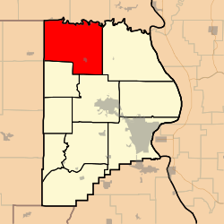
Apple Creek Township is one of ten townships in Cape Girardeau County, Missouri, USA. As of the 2000 census, its population was 1,960.
History
Apple Creek Township was founded in 1872.[3] The township takes its name from Apple Creek.[4]
Geography
Apple Creek Township covers an area of 83.38 square miles (216.0 km2) and contains two incorporated settlements: Oak Ridge and Old Appleton. It contains seven cemeteries: Byrd, Clippard, Dickman, Fulbright, Sides, Trinity and Wheeler.
The streams of Allie Creek, Froggy Branch, Hughes Creek, Little Apple Creek, Poor Creek, Sandy Branch, Sandy Creek and South Fork Apple Creek run through this township.
References
- ↑ "US Board on Geographic Names". United States Geological Survey. 2007-10-25. Retrieved 2008-01-31.
- ↑ "American FactFinder". United States Census Bureau. Archived from the original on 2013-09-11. Retrieved 2008-01-31.
- ↑ History of Southeast Missouri: A Narrative Account of Its Historical Progress, Its People and Its Principal Interests, Volume 1. Lewis Publishing Company. 1912. p. 163.
- ↑ "Cape Girardeau County Place Names, 1928–1945 (archived)". The State Historical Society of Missouri. Archived from the original on 24 June 2016. Retrieved 10 September 2016.
External links
Municipalities and communities of Cape Girardeau County, Missouri, United States | ||
|---|---|---|
| Cities | 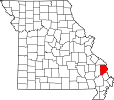 | |
| Villages | ||
| Townships | ||
| Unincorporated communities | ||
| Ghost towns | ||
| Footnotes | ‡This populated place also has portions in an adjacent county or counties | |
This article is issued from Wikipedia - version of the 11/27/2016. The text is available under the Creative Commons Attribution/Share Alike but additional terms may apply for the media files.