Applewold, Pennsylvania
| Applewold, Pennsylvania | |
|---|---|
| Borough | |
|
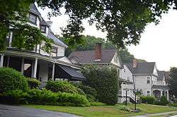
Houses on Allegheny Avenue | |
 Applewold | |
| Coordinates: 40°48′31″N 79°31′20″W / 40.80861°N 79.52222°WCoordinates: 40°48′31″N 79°31′20″W / 40.80861°N 79.52222°W | |
| Country | United States |
| State | Pennsylvania |
| County | Armstrong |
| Incorporated | 1899 |
| Government | |
| • Type | Council-Mayor |
| • Mayor | Gretchen Dosch |
| Area | |
| • Total | 0.04 sq mi (0.1 km2) |
| • Land | 0.04 sq mi (0.1 km2) |
| • Water | 0 sq mi (0 km2) |
| Elevation | 790 ft (240 m) |
| Population (2010) | |
| • Total | 310 |
| • Density | 6,601/sq mi (2,548.7/km2) |
| Time zone | Eastern (EST) (UTC-5) |
| • Summer (DST) | EDT (UTC-4) |
| ZIP code | 16201 |
Applewold is a borough in Armstrong County, Pennsylvania, United States. The population was 310 at the 2010 census.[1]
Geography
Applewold is located at 40°48′31″N 79°31′20″W / 40.80861°N 79.52222°W (40.808634, -79.522177)[2] on the west bank of the Allegheny River about 40 miles (64 km) northeast of Pittsburgh. Applewold is bordered by the borough of West Kittanning to the west, and the borough of Kittanning lies directly across the Allegheny River to the east.
According to the United States Census Bureau, Applewold has a total area of 0.039 square miles (0.1 km2), all of it land.[1]
Demographics
| Historical population | |||
|---|---|---|---|
| Census | Pop. | %± | |
| 1900 | 122 | — | |
| 1910 | 300 | 145.9% | |
| 1920 | 351 | 17.0% | |
| 1930 | 477 | 35.9% | |
| 1940 | 457 | −4.2% | |
| 1950 | 500 | 9.4% | |
| 1960 | 489 | −2.2% | |
| 1970 | 515 | 5.3% | |
| 1980 | 395 | −23.3% | |
| 1990 | 388 | −1.8% | |
| 2000 | 356 | −8.2% | |
| 2010 | 310 | −12.9% | |
| Est. 2015 | 295 | [3] | −4.8% |
| Sources:[4][5] | |||
As of the census[6] of 2000, there were 356 people, 143 households, and 76 families residing in the borough. The population density was 7,302.3 people per square mile (2,749.0/km²). There were 160 housing units at an average density of 3,281.9 per square mile (1,235.5/km²). The racial makeup of the borough was 100.00% White.
There were 143 households, out of which 23.1% had children under the age of 18 living with them, 38.5% were married couples living together, 12.6% had a female householder with no husband present, and 46.2% were non-families. 37.1% of all households were made up of individuals, and 14.0% had someone living alone who was 65 years of age or older. The average household size was 2.17 and the average family size was 2.86.
In the borough the population was spread out, with 20.8% under the age of 18, 8.1% from 18 to 24, 27.0% from 25 to 44, 19.7% from 45 to 64, and 24.4% who were 65 years of age or older. The median age was 40 years. For every 100 females there were 72.0 males. For every 100 females age 18 and over, there were 70.9 males.
The median income for a household in the borough was $30,714, and the median income for a family was $35,625. Males had a median income of $32,500 versus $19,464 for females. The per capita income for the borough was $16,549. About 3.0% of families and 9.8% of the population were below the poverty line, including 13.8% of those under age 18 and 3.8% of those age 65 or over.
References
- 1 2 "Geographic Identifiers: 2010 Demographic Profile Data (G001): Applewold borough, Pennsylvania". U.S. Census Bureau, American Factfinder. Retrieved July 30, 2013.
- ↑ "US Gazetteer files: 2010, 2000, and 1990". United States Census Bureau. 2011-02-12. Retrieved 2011-04-23.
- ↑ "Annual Estimates of the Resident Population for Incorporated Places: April 1, 2010 to July 1, 2015". Retrieved July 2, 2016.
- ↑ "Census of Population and Housing: Decennial Censuses". United States Census Bureau. Retrieved 2012-03-04.
- ↑ "Incorporated Places and Minor Civil Divisions Datasets: Subcounty Resident Population Estimates: April 1, 2010 to July 1, 2012". Population Estimates. U.S. Census Bureau. Archived from the original on 17 June 2013. Retrieved 11 December 2013.
- ↑ "American FactFinder". United States Census Bureau. Archived from the original on 2013-09-11. Retrieved 2008-01-31.
Municipalities and communities of Armstrong County, Pennsylvania, United States | ||
|---|---|---|
| City | 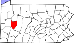 | |
| Boroughs | ||
| Townships | ||
| CDPs | ||
| Unincorporated communities | ||
| Counties |  Map of the Pittsburgh Tri-State with green counties in the metropolitan area and yellow counties in the combined area. | |
|---|---|---|
| Major cities | ||
| Cities and towns 15k-50k (in 2010) | ||
| Airports | ||
| Topics | ||
| ||