Armstrong County, Pennsylvania
| Armstrong County, Pennsylvania | |
|---|---|
|
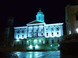
Armstrong County Courthouse | |
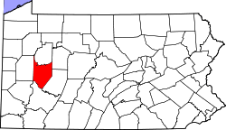 Location in the U.S. state of Pennsylvania | |
 Pennsylvania's location in the U.S. | |
| Founded | March 12, 1800 |
| Named for | John Armstrong |
| Seat | Kittanning |
| Largest borough | Kittanning |
| Area | |
| • Total | 664 sq mi (1,720 km2) |
| • Land | 653 sq mi (1,691 km2) |
| • Water | 11 sq mi (28 km2), 1.6% |
| Population (est.) | |
| • (2015) | 67,052 |
| • Density | 103/sq mi (40/km²) |
| Congressional district | 3rd |
| Time zone | Eastern: UTC-5/-4 |
| Website |
www |
|
Footnotes: | |
| Designated | October 15, 1982[1] |

Armstrong County is a county located in the U.S. state of Pennsylvania. As of the 2010 census, the population was 68,941.[2] The county seat is Kittanning.[3] The county was organized on March 12, 1800, from parts of Allegheny, Westmoreland and Lycoming Counties. It was named in honor of John Armstrong, who represented Pennsylvania in the Continental Congress and served as a major general during the Revolutionary War.
Armstrong County is included in the Pittsburgh, PA Metropolitan Statistical Area.
History
The County was named after John Armstrong, who served as a brigadier general and major general in the Revolutionary War.
Armstrong County is home to the City of Parker, an incorporated third-class city, which was an oil boom town with a population rumored to be approximately 20,000 in 1873, but now is the "Smallest City in America" with a population of just under 800. Parker is located in the extreme northwest portion of the county.
Iron was made in the Brady's Bend area of the county twenty years before there was a foundry in Pittsburgh doing so. Ford City is home to the plate-glass industry, as John Ford created the company which later became Pittsburgh Plate Glass.
Kittanning once boasted more millionnaires than anywhere else in Pennsylvania during the 1880s.
Leechburg was the first place in the United States to use natural gas for metallurgical purposes, in 1869. Natural gas was found while drilling for oil, and eventually introduced into the boilers and furnaces of Siberian Iron Works here.
Freeport, Leechburg and Apollo were communities built along the Pennsylvania Canal, which passed through on the Allegheny and Kiskiminetas rivers, at the southern border of the county.
Geography
According to the U.S. Census Bureau, the county has a total area of 664 square miles (1,720 km2), of which 653 square miles (1,690 km2) is land and 11 square miles (28 km2) (1.6%) is water.[4]
Streams
The Allegheny and Kiskiminetas rivers; Buffalo, Crooked, Cowanshannock, Redbank, and Mahoning creeks; and Carnahan Run, among others, have watersheds within the county. The Murphy, Nicholson, Ross, and Cogley islands are in the Allegheny in Armstrong County.
Adjacent counties
- Clarion County (north)
- Jefferson County (northeast)
- Indiana County (east)
- Westmoreland County (south)
- Allegheny County (southwest)
- Butler County (west)
- Venango County (northwest)
Demographics
| Historical population | |||
|---|---|---|---|
| Census | Pop. | %± | |
| 1800 | 2,399 | — | |
| 1810 | 6,143 | 156.1% | |
| 1820 | 10,324 | 68.1% | |
| 1830 | 17,701 | 71.5% | |
| 1840 | 28,365 | 60.2% | |
| 1850 | 29,560 | 4.2% | |
| 1860 | 35,797 | 21.1% | |
| 1870 | 43,382 | 21.2% | |
| 1880 | 47,641 | 9.8% | |
| 1890 | 46,747 | −1.9% | |
| 1900 | 52,551 | 12.4% | |
| 1910 | 67,880 | 29.2% | |
| 1920 | 75,568 | 11.3% | |
| 1930 | 79,298 | 4.9% | |
| 1940 | 81,087 | 2.3% | |
| 1950 | 80,842 | −0.3% | |
| 1960 | 79,524 | −1.6% | |
| 1970 | 75,590 | −4.9% | |
| 1980 | 77,768 | 2.9% | |
| 1990 | 73,478 | −5.5% | |
| 2000 | 72,392 | −1.5% | |
| 2010 | 68,941 | −4.8% | |
| Est. 2015 | 67,052 | [5] | −2.7% |
| U.S. Decennial Census[6] 1790-1960[7] 1900-1990[8] 1990-2000[9] 2010-2013[2] | |||
As of the census[10] of 2000, there were 72,392 people, 29,005 households, and 20,535 families residing in the county. The population density was 111 people per square mile (43/km²). There were 32,387 housing units at an average density of 50 per square mile (19/km²). The racial makeup of the county was 98.32% White, 0.82% Black or African American, 0.09% Native American, 0.12% Asian, 0.02% Pacific Islander, 0.13% from other races, and 0.50% from two or more races. 0.43% of the population were Hispanic or Latino of any race. 34.6% were of German, 10.8% Italian, 9.3% Irish, 8.7% American, 7.4% English and 5.7% Polish ancestry according to Census 2000.
There were 29,005 households out of which 29.50% had children under the age of 18 living with them, 57.90% were married couples living together, 9.00% had a female householder with no husband present, and 29.20% were non-families. 25.90% of all households were made up of individuals and 13.70% had someone living alone who was 65 years of age or older. The average household size was 2.46 and the average family size was 2.95.
In the county, the population was spread out with 22.90% under the age of 18, 7.20% from 18 to 24, 27.60% from 25 to 44, 24.20% from 45 to 64, and 18.00% who were 65 years of age or older. The median age was 40 years. For every 100 females there were 94.70 males. For every 100 females age 18 and over, there were 92.10 males.
- Birth rate
Armstrong County's live birth rate was 890 births in 1990. Armstrong County's live birth rate in 2000 was 740 births, while in 2011 it had declined further to 680 babies.[11] Over the past 50 years (1960 to 2010), rural Pennsylvania saw a steady decline in both the number and proportion of residents under 18 years old. In 1960, 1.06 million rural residents, or 35 percent of the rural population, were children.
- Teen Pregnancy rate
Armstrong County had a 448 babies born to teens (age15-19) in 2011. In 2015, the number of teen births in Armstrong County was 418.[12]
- County poverty demographics
According to research by The Center for Rural Pennsylvania, which is a legislative Agency of the Pennsylvania General Assembly, the poverty rate for Armstrong County was 13.8% in 2014.[13] The statewide poverty rate was 13.6% in 2014. The 2012 childhood poverty rate by school district was: Allegheny-Clarion Valley School District - 37.2%, Apollo-Ridge School District - 46.6% living at 185% or below than the Federal Poverty Level, Armstrong School District - 48.9%, Freeport Area School District - 27.7%, and Leechburg Area School District - 39.6.[14]
Government and politics
As of November 2008, there were 45,532 registered voters in Armstrong County.[15]
- Republican: 20,763 (45.60%)
- Democratic: 20,525 (45.08%)
- Other Parties: 4,244 (9.32%)
County government
County Commissioners:
- Pat Fabian (Democrat), Chairman
- Jason Renshaw, Vice-Chairman
- George J. Skamai, Secretary
District Attorney:
- Scott J. Andreassi (Democrat)
Sheriff:
- Bill Rupert (Democrat)
Controller:
- Myra "Tammy" Miller (Republican)
Treasurer:
- Amanda Hiles
Register of Wills and Recorder of Deeds:
- Marianne Hileman (Republican)
Prothonotary and Clerk of Courts:
- Brenda C. George (Republican)
Jury Commissioners:
- Karen Shreckengost (Republican)
- Paul Kijowski (Democrat)
Judges:
- Kenneth G. Valasek, President Judge (Democrat)
- James Panchik (Democrat)
- Joseph A. Nickleach, Sr. Judge (Democrat)
State Senate
- Jim Ferlo, Democrat, Pennsylvania's 38th Senatorial District
- Donald C. White, Republican, Pennsylvania's 41st Senatorial District
State House Of Representatives
- Eli Evankovich, Republican, Pennsylvania's 54th Representative District
- Jeff Pyle, Republican, Pennsylvania's 60th Representative District
- Joseph A. Petrarca, Democrat, Pennsylvania's 55th Representative District
- Donna Oberlander, Republican, Pennsylvania's 63rd Representative District
- Sam Smith, Republican, Pennsylvania's 66th Representative District
United States House of Representatives
Education
Colleges and universities
- Indiana University of Pennsylvania Northpointe - South Buffalo Township
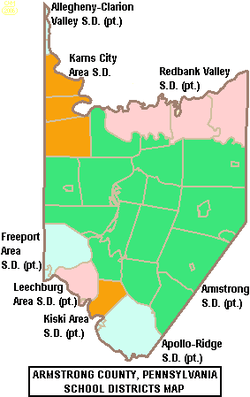
Public school districts
- Allegheny-Clarion Valley School District (part) - ranked 415th (2012), 448th in 2010
- Apollo-Ridge School District (part) - ranked 406 (2012), 437th (2010)
- Armstrong School District (part, 3 high schools) - ranked 342nd (2012), 328th in 2010
- Freeport Area School District (part) - ranked 148th (2012), 124th in 2010
- Karns City Area School District (part) - ranked 193rd (2012), 177th in 2010
- Kiski Area School District (part) - ranked 96th (2012), 101st in 2010
- Leechburg Area School District (part) - ranked 416th (2012), 400th in 2010
- Redbank Valley School District (part) - ranked 298th (2012), 279th in 2010
The 498 school districts of Pennsylvania, that have high schools, were ranked for student academic achievement as demonstrated by four years of writing, science math and reading PSSA results by the Pittsburgh Business Times in 2010.
Technology school
- Lenape Technology School - Ford City
Private schools
As reported by the Pennsylvania Department of Education - EdNA. April 2012.
- Adelphoi Village Miller Home - Apollo
- Divine Redeemer School - Ford City
- Dry Knob Amish School - Smicksburg
- Evangelical Lutheran School - Worthington
- Grace Christian School - Kittanning
- Meadow View School - Dayton
- Model Education Program - Kittanning
- New Bethlehem Wesleyan Methodist School - New Bethlehem
- Orchard Hills Christian Academy - Apollo
- Owl Hollow Amish School - Smicksburg
- Shady Lane Amish School - Smicksburg
- Shady Run Amish School - Smicksburg
- Stony Acres Amish School - Smicksburg
- Stony Flat Amish School - Smicksburg
- United Cerebral Palsy Of Western Pennsylvania - Spring Church
- Whippoorwill School - Smicksburg
- Worthington Baptist Christian School - Worthington
Libraries
There are six public libraries in Armstrong County:[16][17]
- Apollo Memorial Library - Apollo, PA
- Ford City Public Library - Ford City, PA
- Freeport Area Library - Freeport, PA
- Kittanning Public Library - Kittanning, PA
- Leechburg Public Library - Leechburg, PA
- Worthington West Franklin Community Library - Worthington, PA
Communities
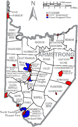
Under Pennsylvania law, there are four types of incorporated municipalities: cities, boroughs, townships, and, in at most two cases, towns. The following cities, boroughs and townships are located in Armstrong County:
City
Boroughs
Townships
Census-designated places
Census-designated places are geographical areas designated by the U.S. Census Bureau for the purposes of compiling demographic data. They are not actual jurisdictions under Pennsylvania law. Other unincorporated communities, such as villages, may be listed here as well.
Former community
Population ranking
The population ranking of the following table is based on the 2010 census of Armstrong County.[18]
† county seat
| Rank | City/Town/etc. | Population (2010 Census) | Municipal type | Incorporated |
|---|---|---|---|---|
| 1 | † Kittanning | 4,044 | Borough | 1803 |
| 2 | Ford City | 2,991 | Borough | 1889 |
| 3 | Leechburg | 2,156 | Borough | 1850 |
| 4 | Orchard Hills | 1,952 | CDP | |
| 5 | Freeport | 1,813 | Borough | 1833 |
| 6 | Apollo | 1,647 | Borough | 1848 |
| 7 | North Apollo | 1,297 | Borough | |
| 8 | West Hills | 1,263 | CDP | |
| 9 | West Kittanning | 1,175 | Borough | 1900 |
| 10 | Lenape Heights | 1,167 | CDP | |
| 11 | Rural Valley | 876 | Borough | |
| 12 | Parker | 840 | City | 1873 |
| 13 | Pleasant View | 780 | CDP | |
| 14 | Worthington | 639 | Borough | 1855 |
| 15 | Dayton | 553 | Borough | 1873 |
| 16 | South Bethlehem | 481 | Borough | |
| 17 | North Vandergrift | 447 | CDP | |
| 18 | Manorville | 410 | Borough | |
| 19 | Ford Cliff | 371 | Borough | 1922 |
| 20 | Elderton | 356 | Borough | 1859 |
| 21 | Templeton | 325 | CDP | |
| 22 | Applewold | 310 | Borough | 1899 |
| 23 | Kiskimere | 136 | CDP | |
| 24 | Atwood | 107 | Borough | 1884 |
See also
- List of counties in Pennsylvania
- National Register of Historic Places listings in Armstrong County, Pennsylvania
References
- ↑ "PHMC Historical Markers Search" (Searchable database). Pennsylvania Historical and Museum Commission. Commonwealth of Pennsylvania. Retrieved 2014-01-25.
- 1 2 "State & County QuickFacts". United States Census Bureau. Retrieved November 16, 2013.
- ↑ "Find a County". National Association of Counties. Archived from the original on 2011-05-31. Retrieved 2011-06-07.
- ↑ "2010 Census Gazetteer Files". United States Census Bureau. August 22, 2012. Retrieved March 4, 2015.
- ↑ "County Totals Dataset: Population, Population Change and Estimated Components of Population Change: April 1, 2010 to July 1, 2015". Retrieved July 2, 2016.
- ↑ "U.S. Decennial Census". United States Census Bureau. Archived from the original on May 11, 2015. Retrieved March 4, 2015.
- ↑ "Historical Census Browser". University of Virginia Library. Retrieved March 4, 2015.
- ↑ Forstall, Richard L., ed. (March 27, 1995). "Population of Counties by Decennial Census: 1900 to 1990". United States Census Bureau. Retrieved March 4, 2015.
- ↑ "Census 2000 PHC-T-4. Ranking Tables for Counties: 1990 and 2000" (PDF). United States Census Bureau. April 2, 2001. Retrieved March 4, 2015.
- ↑ "American FactFinder". United States Census Bureau. Archived from the original on 2013-09-11. Retrieved 2008-01-31.
- ↑ Pennsylvania Department of Health, Birth Age County Reports 1990 and 2011, 2011
- ↑ Robert Wood Johnson Foundation, (2016). "Pennsylvania Teen Births 2015,".
- ↑ US Census Bureau (2015). "Poverty Rates by County Small Area Income and Poverty Estimates".
- ↑ Pennsylvania Budget and Policy Center (2012). "Student Poverty Concentration 2012".
- ↑ Running for Office. Dos.state.pa.us. Retrieved on 2013-07-23.
- ↑ Armstrong Libraries. Armstrong Libraries. Retrieved on 2013-07-23.
- ↑ Freeport Area Library Association - Home. Freeportlibrary.org (2013-07-12). Retrieved on 2013-07-23.
- ↑ "Archived copy". Archived from the original on 2013-12-21. Retrieved 2015-04-20.
External links
| Wikimedia Commons has media related to Armstrong County, Pennsylvania. |
 |
Venango County | Clarion County | Jefferson County | |
| Butler County | |
Indiana County | ||
| ||||
| | ||||
| Allegheny County | Westmoreland County |
Municipalities and communities of Armstrong County, Pennsylvania, United States | ||
|---|---|---|
| City | | |
| Boroughs | ||
| Townships | ||
| CDPs | ||
| Unincorporated communities | ||
| Counties | 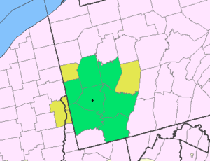 Map of the Pittsburgh Tri-State with green counties in the metropolitan area and yellow counties in the combined area. | |
|---|---|---|
| Major cities | ||
| Cities and towns 15k-50k (in 2010) | ||
| Airports | ||
| Topics | ||
| ||
Coordinates: 40°49′N 79°28′W / 40.81°N 79.46°W