Apricot, Washington
| Apricot, Washington Apricot Spur | |
|---|---|
| Unincorporated community | |
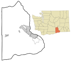 Apricot, Washington Location of Apricot, Washington | |
| Coordinates: 46°14′11″N 119°51′27″W / 46.2365213°N 119.8575366°WCoordinates: 46°14′11″N 119°51′27″W / 46.2365213°N 119.8575366°W[1] | |
| Country | United States |
| State | Washington |
| County | Benton |
| Elevation[2] | 823 ft (251 m) |
| Time zone | Pacific (PST) (UTC-8) |
| • Summer (DST) | PDT (UTC-7) |
| ZIP code | 99350 |
| Area code(s) | 509 |
| GNIS feature ID | 1510784[2] |
Apricot is an unincorporated community in Benton County, Washington, United States, located between Prosser and Grandview.
The community was established in 1916 and probably named Apricot "for the fine apricot land offered" by the land agent of the Yakima Irrigating and Improvement Company. The community was once a railroad siding for the Northern Pacific Railroad.[3][4]
References
- ↑ "Apricot". Geographic Names Information System. United States Geological Survey. Retrieved 2012-10-28.
- 1 2 "US Board on Geographic Names". United States Geological Survey. 2007-10-25. Retrieved 2008-01-31.
- ↑ "Washington Place Names database". Tacoma Public Library. Retrieved October 31, 2012.
- ↑ "Station Roster Master List: Apricot". Northern Pacific Railway Historical Association. Retrieved October 31, 2012.
Municipalities and communities of Benton County, Washington, United States | ||
|---|---|---|
| Cities | 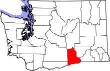 | |
| CDPs | ||
| Unincorporated communities | ||
| Unincorporated communities | ||
This article is issued from Wikipedia - version of the 10/16/2016. The text is available under the Creative Commons Attribution/Share Alike but additional terms may apply for the media files.