Whitstran, Washington
| Whitstran, Washington Whitstran Spur | |
|---|---|
| Unincorporated community | |
|
Looking east in Whitstran. | |
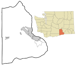 Whitstran, Washington Location of Whitstran, Washington | |
| Coordinates: 46°14′07″N 119°42′20″W / 46.2354111°N 119.7055870°WCoordinates: 46°14′07″N 119°42′20″W / 46.2354111°N 119.7055870°W[1] | |
| Country | United States |
| State | Washington |
| County | Benton |
| Elevation | 679 ft (207 m) |
| Time zone | Pacific (PST) (UTC-8) |
| • Summer (DST) | PDT (UTC-7) |
| ZIP code | 99350 |
| Area code(s) | 509 |
| FIPS code | 53-78540 |
| GNIS feature ID | 1512805[2] |


Whitstran is a small, unincorporated community in Benton County, Washington, located approximately four miles Northeast of Prosser and approximately ten miles west of Benton City. The focal point of the community is at the intersection of North Rothrock Road and Foisy Road, where there is a small grocery store, and nearby Whitstran Elementary School.
|


History
The settlement of Valley Heights originated in 1907 when Seattle developer Charles Jorgen Smith, purchased property in present-day Whitstran, which became known as Valley Heights Orchard Tracts.[3] It was also called Swede Settlement for a time because of a number of Scandinavians who purchased property in the area. A rail line was built in 1911 and a town site was platted by Mary Biggam. By 1919 the community began to be known as Whitstran and the name Valley Heights eventually faded from use.[4]
The community's name was changed to Whitstran by the Northern Pacific Railway in honor of two retired railroad nurses, Laura Whitaker and May A. Strangeways, who were cousins who developed a small acreage nearby.[5]
Another source indicates that the town was named by the North Yakima and Valley Railway Company in honor of a landowner from whom a right-of-way had been acquired. The railway station was previously known as Whitstran Spur.[6]
E.W. Fry built the first store in Whitstran in 1916. Jim McCorkle has owned the store, now known as McCorkle's, since 1993. Previously it was known as Blake's Corner Market and Whitstran Trading Company.[7]
In the 1950s, a new school replaced the previous one room school.[7] The school is now Whitstran Elementary School.
Schools
- Whitstran Elementary School Grades K-5
References
- ↑ "Whitstran". Geographic Names Information System. United States Geological Survey. Retrieved 2012-10-29.
- ↑ "US Board on Geographic Names". United States Geological Survey. 2007-10-25. Retrieved 2008-01-31.
- ↑ Bagley, Clarence (1916). History of Seattle from the earliest settlement to the present time (Volume 3). Chicago, IL: S.J. Clarke Publishing Company.
- ↑ Davis; Bergum. "Washington Place Names database". p. 73. Retrieved 13 July 2011.
- ↑ Davis; Bergum. "Washington Place Names database". pp. 80–81. Retrieved 13 July 2011.
- ↑ "Station Roster Master List: Whitstran". Northern Pacific Railway Historic Association. Retrieved 13 July 2011.
- 1 2 Courtney, Ross (March 28, 2004). "Not Much Left for Whitstran but the Stores". Yakima-Herald Republic. Retrieved 13 July 2011.
External links
| Wikimedia Commons has media related to Whitstran, Washington. |
Municipalities and communities of Benton County, Washington, United States | ||
|---|---|---|
| Cities | 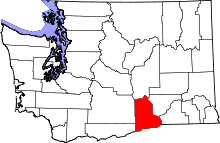 | |
| CDPs | ||
| Unincorporated communities | ||
| Unincorporated communities | ||