Arkabutla Lake
| Arkabutla Lake | |
|---|---|
 Arkabutla Lake | |
| Location | DeSoto / Tate counties, Mississippi, United States |
| Coordinates | 34°45′42″N 090°07′20″W / 34.76167°N 90.12222°WCoordinates: 34°45′42″N 090°07′20″W / 34.76167°N 90.12222°W |
| Type | reservoir |
| Primary inflows | Coldwater River |
| Primary outflows | Coldwater River |
| Basin countries | United States |
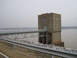
Arkabutla Lake is a reservoir on the Coldwater River in the U.S. state of Mississippi. The dam is located on Arkabutla Dam Rd approximately 4 miles (6.4 km) north of the small community of Arkabutla. It is one of four Flood Damage Reduction reservoirs in northern Mississippi, with the others being Sardis, Enid and Grenada Lakes. With an annual visitation exceeding 2 million people, Arkabutla Lake accommodates a wide variety of recreational interest throughout the entire year. The Arkabutla Lake project includes 57,250 acres (231.7 km2) of land and water. The dam is 11,500 ft (3,500 m) long with an average height of 67 ft (20 m). There are 37,700 acres (153 km2) of land at the project which are open to the public for hunting.
History
According to the U.S. Army Corp of Engineers website, after a series of disastrous floods during the mid-19th century and early 20th century, high priority was given to flood control projects. The worst flood in modern history of the Lower Mississippi Valley occurred in 1927. The Great Mississippi Flood of 1927 spawned a comprehensive program for flood control along the Mississippi River and its tributaries and the U.S. Army Corps of Engineers became the planners, designers and builders of the flood control projects. These projects were made possible by the passing of the Flood Control Act of 1937.
Engineers determined the headwaters of the Yazoo River contributed to or caused much of the flooding that occurred in the Mississippi Delta region. In addition to the construction of levees along the Yazoo River, four flood control reservoirs were constructed in north Mississippi as part of the Yazoo Basin Headwater Project. Arkabutla Dam, the second of the dams to be built, was constructed on the Coldwater River.
In 1942, the U.S. Government moved the town of Coldwater and approximately 700 residents at a cost of $250,000 to its present location 1-mile (1.6 km) south of the original site. Today there is a monument dedicated to the old town of Coldwater just west of the Coldwater exit off Interstate 55. There you can see a few remnants of the old town; however a majority of the site remains underwater year round.
When completed, the Yazoo Headwater Project will protect 1,209,000 acres (4,890 km2) of land against flooding and will partially protect another 303,000 acres (1,230 km2). Benefits of the Headwater Project are reduced flooding around the cities of Greenwood, Yazoo City, Belzoni, and other smaller communities within the Yazoo River Basin and increased agricultural and industrial productivity because more land is available for these purposes. As a result, the region’s national and international markets for produce have greatly increased and families have benefited from the growing job market.
Cultural references
In the movie O Brother, Where Art Thou?, Everett McGill's treasure is buried at a cabin located in a valley that is flooded during the construction of Arkabutla Reservoir.[1] A brief still shot of a newspaper dated Tuesday, July 13, 1937 has a headline which reads "T.V.A. FINALIZING PLANS FOR FLOODING OF ARKTABUTTA VALLEY".
References
| Wikimedia Commons has media related to Arkabutla Lake. |
- ↑ synopsis for O Brother, Where Art Thou? imdb.com (accessed July 4, 2011)
External links
- Arkabutla Lake official web page - USACE official web page.