Arkansas Highway 160
| ||||
|---|---|---|---|---|
 | ||||
| Route information | ||||
| Maintained by AHTD | ||||
| Section 1 | ||||
| Length: | 51.55 mi[1] (82.96 km) | |||
| West end: |
| |||
| East end: |
| |||
| Section 2 | ||||
| Length: | 14.73 mi[1] (23.71 km) | |||
| West end: |
| |||
| East end: |
| |||
| Section 3 | ||||
| Length: | 38.99 mi[1] (62.75 km) | |||
| West end: |
| |||
| East end: |
| |||
| Section 4 | ||||
| Length: | 22.73 mi[1] (36.58 km) | |||
| West end: |
| |||
| East end: |
| |||
| Highway system | ||||
| ||||

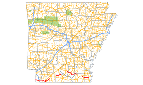
Arkansas Highway 160 (AR 160 and Hwy. 160) is a designation for four state highways in Lower Arkansas. The northernmost segment of 51.55 miles (82.96 km) runs from Farm to Market Road 249 and State Line Avenue at the Texas state line near Bloomburg, Texas east to Highway 19 at Macedonia.[1] A second segment of 14.73 miles (23.71 km) runs east from Highway 57 east to Highway 7 Business in Smackover.[2] In southern Calhoun County, Highway 160 begins at US Route 278 (US 278) and runs east to US 425 in Fountain Hill.[3][4] A fourth segment begins at US 82 and runs 22.73 miles (36.58 km) east to US 65 at Chicot Junction.[4][5]
Route description
Texas to Macedonia
Highway 160 begins at State Line Avenue as Farm to Market Road 249 near Bloomburg, Texas and heads east to a junction with Highway 237 before a junction with US 71 near Doddridge. The route runs underneath AR 549 (future Interstate 49) before it crosses the Red River to enter Lafayette County.[6] The route continues east, passing Gin City where it meets Highway 360, Conway Cemetery on the National Register of Historic Places, and Highway 29 in Bradley.[7] Arkansas Highway 160 heads southeast around Lake Erling before forming a concurrency north with Highway 53 to Walker Creek.
The route enters Columbia County near Taylor where it forms a 0.13 miles (0.21 km) officially designated exception over US 371.[8] before continuing northeast to Macedonia where it terminates at Highway 19.[9]
Mount Holly to Smackover
Highway 160 begins at Highway 57 in Mount Holly in the northwest corner of Union County. The route runs northeast to a junction with Highway 7 outside Smackover before entering the city limits.[10] Highway 160 terminates at Highway 7 Business (7th Street) near Smackover High School.[10]
Harrell to Fountain Hill route
Arkansas Highway 160 travels south until meeting AR 172, after which it begins to arrow east to join with US 63/AR 15. The merge continues until Hermitage, when AR 160 continues south past Ingalls and Vick (crossing the Fordyce & Princeton Railroad). The route then angles north towards Highway 8 in Johnsville. Beyond Johnsville, AR 160 becomes concurrent with AR 133 until Fountain Hill, where it terminates.
See also
![]() Arkansas portal
Arkansas portal
![]() U.S. Roads portal
U.S. Roads portal
References
- 1 2 3 4 5 "[Arkansas] State Highways 2009 (Database)." April 2010. AHTD: Planning and Research Division. Database. Retrieved April 3, 2011.
- ↑ Route and Section Map - Union County, Arkansas (PDF) (Map). Arkansas State Highway and Transportation Department. Retrieved October 27, 2011.
- ↑ Route and Section Map - Calhoun County, Arkansas (PDF) (Map). Arkansas State Highway and Transportation Department. Retrieved October 27, 2011.
- 1 2 Route and Section Map - Ashley County, Arkansas (PDF) (Map). Arkansas State Highway and Transportation Department. Retrieved October 27, 2011.
- ↑ Route and Section Map - Chicot County, Arkansas (PDF) (Map). Arkansas State Highway and Transportation Department. Retrieved October 27, 2011.
- ↑ General Highway Map, Miller County, Arkansas (PDF) (Map). 1:62500. Cartography by Planning and Research Division. Arkansas State Highway and Transportation Department. 2010. Retrieved October 27, 2011.
- ↑ General Highway Map, Lafayette County, Arkansas (PDF) (Map). 1:62500. Cartography by Planning and Research Division. Arkansas State Highway and Transportation Department. 2006. Retrieved October 27, 2011.
- ↑ Route and Section Map - Columbia County, Arkansas (PDF) (Map). Arkansas State Highway and Transportation Department. Retrieved October 27, 2011.
- ↑ General Highway Map, Columbia County, Arkansas (PDF) (Map). 1:62500. Cartography by Planning and Research Division. Arkansas State Highway and Transportation Department. 2008. Retrieved October 27, 2011.
- 1 2 General Highway Map, Union County, Arkansas (PDF) (Map). 1:62500. Cartography by Planning and Research Division. Arkansas State Highway and Transportation Department. 2010. Retrieved October 27, 2011.