Athelstane Township, Clay County, Kansas
| Athelstane Township | |
|---|---|
| Township | |
 Location in Clay County | |
| Coordinates: 39°10′45″N 097°12′11″W / 39.17917°N 97.20306°WCoordinates: 39°10′45″N 097°12′11″W / 39.17917°N 97.20306°W | |
| Country | United States |
| State | Kansas |
| County | Clay |
| Area | |
| • Total | 36.07 sq mi (93.43 km2) |
| • Land | 36.06 sq mi (93.4 km2) |
| • Water | 0.01 sq mi (0.03 km2) 0.03% |
| Elevation | 1,204 ft (367 m) |
| Population (2000) | |
| • Total | 144 |
| • Density | 4/sq mi (1.5/km2) |
| GNIS feature ID | 0476298 |
Athelstane Township is a township in Clay County, Kansas, USA. As of the 2000 census, its population was 144. It was named after Athelstaneford, Scotland when Robert Hamilton, an early settler, selected the name for the post office.[1]
Geography
Athelstane Township covers an area of 36.07 square miles (93.4 km2) and contains no incorporated settlements. According to the USGS, it contains one cemetery, Athelstane.
The streams of Badger Creek, Basket Creek, and McMurray Creek run through this township.
References
- ↑ "A Continued Story of Clay County by Townships—Athelstane". The Times. June 22, 1899. p. 1. Retrieved September 9, 2014 – via Newspapers.com.

External links
Municipalities and communities of Clay County, Kansas, United States | ||
|---|---|---|
| Cities | 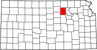 | |
| Unincorporated communities | ||
| Townships | ||
| Footnotes | ‡This populated place also has portions in an adjacent county or counties | |
This article is issued from Wikipedia - version of the 10/22/2015. The text is available under the Creative Commons Attribution/Share Alike but additional terms may apply for the media files.