Atlántida, Uruguay
| Atlántida | |
|---|---|
| City | |
 | |
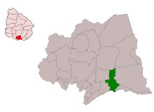
 Atlántida Location within Uruguay | |
| Coordinates: 34°46′0″S 55°45′0″W / 34.76667°S 55.75000°W | |
| Country |
|
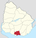
| Department | Canelones Department |
| Founded | 1911 |
| Population (2011) | |
| • Total | 5,562 |
| Time zone | UTC -3 |
| Postal code | 16000 |
| Dial plan | +598 437 (+5 digits) |
Atlántida is a resort town of the Costa de Oro in Canelones Department of Uruguay, 45 kilometres (28 mi) east of Montevideo.
Atlántida is also the name of the municipality to which the town belongs and which includes a few more resort towns to the north and to the west of the town, i.e. Estación Atlántida, City Golf, Villa Argentina, Fortín de Santa Rosa and rural areas to their north.
Location
The resort is located on Ruta Interbalnearia, near the junction with Route 11.
History
Atlántida started in the beginning of the 20th century as a resort for the elite class of Montevideo and remained so until the mid-1950s. Today it is mainly a middle class resort with more than 4,600 permanent inhabitants.
The first plans of a resort in the area were drawn in 1911 and in the next year the parcelling and selling of plots began. In 1913 the Hotel Las Toscas was built near the beach,[1] which in 1915 took on its actual name, Atlántida. The development accelerated from 1939 onwards, when Natalio Michelizzi (a wealthy Italian businessman living in Buenos Aires) decided to buy all the land that had not been parcelled or developed and invested in its development.[1] On 7 September 1967 by the Act of Ley N° 13.609 it became classified as a city.[2]
Population
According to the 2011 census, Atlántida had a population of 5,562.[3] In 2010, the Intendencia de Canelones had recorded a population of 10,393 for the municipality during the elections.[4]
| Year | Population |
|---|---|
| 1963 | 1,559 |
| 1975 | 2,268 |
| 1985 | 2,764 |
| 1996 | 3,989 |
| 2004 | 4,580 |
| 2011 | 5,562 |
Source: Instituto Nacional de Estadística de Uruguay[5]
Beaches

The beaches of Atlántida are frequented by mainly by wealthy Uruguayans. They are characterized by being bordered by pine trees. the main beaches are Playa La Brava and Playa La Mansa. La Mansa is ideal for families, since the water is very calm, whilst La Brava typically has much rougher currents and is very popular with young people who enjoy water sports. These beaches are completely deserted in the winter months.
Landmarks
- Dieste's Church of Christ the Worker, built in 1958-60 by Eladio Dieste is located in the northern suburb of Estación Atlántida, north of the Ruta Interbalnearia. It is architecturally striking, described as "a simple rectangle, with side walls rising up in undulating curves to the maximum amplitude of their arcs".[6]
- In the nearby resort Villa Argentina, "El Águila" is an enigmatic and attractive stone building that gave rise to several legends, from a smuggler's haven, a Nazi observatory and a "cosmic energy centre". It was built by Michellizzi, who originally called it "La Quimera". For a while, La Quimera was used by Michellizzi as meeting place with friends and to spend long hours of reading in solitude. After he died, the building and its gardens deteriorated. Michellizzi also founded one of the first hotels in the area, Hotel Planeta Palace, which still stands today.
Places of worship
- Church of the Sacred Heart (Roman Catholic)
Images
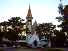 Iglesia Sagrado Corazón in Atlántida |
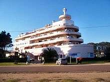 Edificio El Planeta in Atlántida |
 El Águila, Villa Argentina, near Atlántida |
References
- 1 2 Burford, Tim (2010). Uruguay. Bradt Travel Guides. p. 161. ISBN 978-1-84162-316-0. Retrieved 30 May 2011.
- ↑ "LEY N° 13.609". República Oriental del Uruguay, Poder Legislativo. 1967. Archived from the original on 4 March 2016. Retrieved 28 June 2011.
- ↑ "Censos 2011 Cuadros Canelones". INE. 2012. Archived from the original on October 10, 2012. Retrieved 25 August 2012.
- ↑ "ELECCIONES - Canelones". El Observador. Retrieved 2 February 2012.
- ↑ "Statistics of urban localities (1963–2004)" (PDF). INE. 2012. Retrieved 9 September 2012.
- ↑ Ching, Frank; Jarzombek, Mark; Prakash, Vikramaditya (2007). A global history of architecture. J. Wiley & Sons. p. 732. ISBN 978-0-471-26892-5. Retrieved 30 May 2011.
External links
| Wikimedia Commons has media related to Atlántida (Uruguay). |
- Official website
- El Pais/Viajes, article about Atlántida
- Correo Uruguayo, Stamp for the 100 years of Atlántida, showing the Edificio Planeta.
- INE map of Villa Argentina, Atlántida, Estación Atlántida, Las Toscas, City Golf, and Fortin de Santa Rosa
|
Capital: Canelones | ||
| Towns and villages |
|  |
| Resorts of the Ciudad de la Costa | ||
| Sights |
| |