Au Sable, New York
| Au Sable, New York | |
|---|---|
| Town | |
|
| |
 Location in Clinton County and the state of New York. | |
| Coordinates: 44°31′N 73°31′W / 44.517°N 73.517°WCoordinates: 44°31′N 73°31′W / 44.517°N 73.517°W | |
| Country | United States |
| State | New York |
| County | Clinton |
| Government | |
| • Type | Town Council |
| • Town Supervisor | Sandy Senecal (D) |
| • Town Council |
Members' List
|
| Area | |
| • Total | 43.9 sq mi (113.6 km2) |
| • Land | 39.1 sq mi (101.3 km2) |
| • Water | 4.7 sq mi (12.3 km2) |
| Elevation | 778 ft (237 m) |
| Population (2010) | |
| • Total | 3,146 |
| • Density | 81/sq mi (31.1/km2) |
| Time zone | Eastern (EST) (UTC-5) |
| • Summer (DST) | EDT (UTC-4) |
| FIPS code | 36-03221 |
| GNIS feature ID | 0978699 |
Au Sable, or Ausable, is a town in Clinton County, New York, United States. The population was 3,146 at the 2010 census.[1] The name is from the Ausable River that flows through the town and means "at the sand".
The town is in the southeast corner of the county, south of Plattsburgh.
History
The land was first settled around 1795. The town was formed from part of the town of Peru in 1839. Mining was an important early industry in the town.
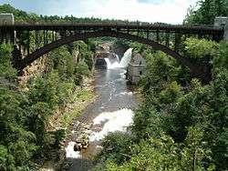
The AuSable Chasm Bridge was built in 1932-1933.[2]
Geography
According to the United States Census Bureau, the town has a total area of 43.9 square miles (113.6 km2), of which 39.1 square miles (101.3 km2) is land and 4.7 square miles (12.3 km2), or 10.81%, is water.[1]
The town is bordered by Lake Champlain to the east. The south town line is the border of Essex County.
Ausable Chasm, a popular tourist location on the Ausable River, is along the southeast border of the town.
Interstate 87, the Adirondack Northway, is an important north-south highway in Ausable, with access to the town from Exit 34 (Route 9N). U.S. Route 9 runs closer to Lake Champlain than the Northway. New York State Route 9N runs east-west along the south town line, joining US 9 in Keesville. New York State Route 22 is a north-south highway mostly lying west of the Northway.
Demographics
| Historical population | |||
|---|---|---|---|
| Census | Pop. | %± | |
| 1840 | 3,222 | — | |
| 1850 | 4,492 | 39.4% | |
| 1860 | 3,227 | −28.2% | |
| 1870 | 2,863 | −11.3% | |
| 1880 | 2,980 | 4.1% | |
| 1890 | 2,532 | −15.0% | |
| 1900 | 2,195 | −13.3% | |
| 1910 | 2,045 | −6.8% | |
| 1920 | 1,636 | −20.0% | |
| 1930 | 1,868 | 14.2% | |
| 1940 | 1,985 | 6.3% | |
| 1950 | 1,903 | −4.1% | |
| 1960 | 2,605 | 36.9% | |
| 1970 | 2,652 | 1.8% | |
| 1980 | 2,792 | 5.3% | |
| 1990 | 2,870 | 2.8% | |
| 2000 | 3,015 | 5.1% | |
| 2010 | 3,146 | 4.3% | |
| Est. 2014 | 3,129 | [3] | −0.5% |
As of the census[5] of 2000, there were 3,015 people, 1,180 households, and 831 families residing in the town. The population density was 77.1 people per square mile (29.8/km²). There were 1,347 housing units at an average density of 34.4 per square mile (13.3/km²). The racial makeup of the town was 97.78% White, 0.80% African American, 0.23% Native American, 0.30% Asian, 0.27% from other races, and 0.63% from two or more races. Hispanic or Latino of any race were 1.33% of the population.
There were 1,180 households out of which 33.2% had children under the age of 18 living with them, 53.7% were married couples living together, 11.6% had a female householder with no husband present, and 29.5% were non-families. 23.6% of all households were made up of individuals and 12.1% had someone living alone who was 65 years of age or older. The average household size was 2.53 and the average family size was 2.95.
In the town the population was spread out with 26.0% under the age of 18, 7.5% from 18 to 24, 29.1% from 25 to 44, 23.0% from 45 to 64, and 14.4% who were 65 years of age or older. The median age was 38 years. For every 100 females there were 97.4 males. For every 100 females age 18 and over, there were 92.0 males.
The median income for a household in the town was $34,118, and the median income for a family was $39,906. Males had a median income of $30,213 versus $22,933 for females. The per capita income for the town was $15,789. About 7.7% of families and 12.0% of the population were below the poverty line, including 16.9% of those under age 18 and 14.7% of those age 65 or over.
Communities and locations in Au Sable
- Ausable Beach – A location on the shore of Lake Champlain at the mouth of the Ausable River.
- Ausable Chasm – A deep gorge carved by the Ausable River. It is a privately owned tourist attraction. The name is also used by a hamlet in the town next to the gorge.
- Ausable River – A river that flows along the town border to Lake Champlain.
- Birmingham Falls – A historic location near Keeseville.
- Clintonville – A hamlet near the south town line on NY 9N. The community was incorporated as a village in 1825, but later abandoned that status.
- Harkness – A hamlet near the north town line.
- Keese Corners – A location near the north town line.
- Keeseville – The village of Keeseville on US-9 at the south town line. It extends south into the town of Chesterfield in Essex County.
- New Sweden – A historic location in the town.
- Rogers – A hamlet in the southwest corner of the town on NY 9N.
- Thomasville – A location in the southwest part of the town.
- Union – A historic location at the north town line.
References
- 1 2 "Geographic Identifiers: 2010 Demographic Profile Data (G001): Au Sable town, Clinton County, New York". U.S. Census Bureau, American Factfinder. Retrieved December 2, 2014.
- ↑ Steven Engelhart and Linda M. Garofalini (February 1998). "National Register of Historic Places Registration: AuSable Chasm Bridge". New York State Office of Parks, Recreation and Historic Preservation. Retrieved 2009-06-14. See also: "Accompanying 15 photos".
- ↑ "Annual Estimates of the Resident Population for Incorporated Places: April 1, 2010 to July 1, 2014". Retrieved June 4, 2015.
- ↑ "Census of Population and Housing". Census.gov. Archived from the original on May 11, 2015. Retrieved June 4, 2015.
- ↑ "American FactFinder". United States Census Bureau. Archived from the original on September 11, 2013. Retrieved 2008-01-31.
External links
Municipalities and communities of Clinton County, New York, United States | ||
|---|---|---|
| City | 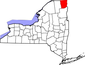 | |
| Towns | ||
| Villages | ||
| CDPs | ||
| Other hamlets | ||
| Footnotes | ‡This populated place also has portions in an adjacent county or counties | |