Keeseville, New York
| Keeseville, New York | |
|---|---|
| Hamlet | |
|
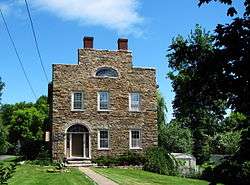
Richard Keese II house (1823) | |
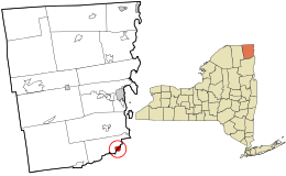 Location in Clinton County and the state of New York. | |
| Coordinates: 44°30′N 73°29′W / 44.500°N 73.483°WCoordinates: 44°30′N 73°29′W / 44.500°N 73.483°W | |
| Country | United States |
| State | New York |
| Counties | Clinton, Essex |
| Towns | Au Sable and Chesterfield |
| Incorporated | May 1878[1] |
| Dissolved | December 31, 2014 |
| Area | |
| • Total | 1.2 sq mi (3.2 km2) |
| • Land | 1.2 sq mi (3.0 km2) |
| • Water | 0.04 sq mi (0.1 km2) |
| Elevation | 417 ft (127 m) |
| Population (2010) | |
| • Total | 1,815 |
| • Density | 1,547/sq mi (597.2/km2) |
| Time zone | Eastern (EST) (UTC-5) |
| • Summer (DST) | EDT (UTC-4) |
| ZIP codes | 12911, 12924, 12944 |
| Area code(s) | 518 |
| FIPS code | 36-39089 |
| GNIS feature ID | 2390918 |
Keeseville is a hamlet in Clinton and Essex counties, New York, in the United States. The population was 1,815 at the 2010 census.[2] The village is named after the Keese family. Keeseville is in the towns of Au Sable and Chesterfield and is south of Plattsburgh. It is also inside the Adirondack Park. On January 23, 2013, the town's selectboard voted to dissolve the village.[3]
As of 2016, the U.S. Census Bureau continues to list Keeseville as a village. It should eventually be redefined as a census-designated place.
History
The hamlet was originally called "Anderson Falls", but the name was changed circa 1812 to "Keeseville", after a local manufacturer and businessman. The early hamlet was an industrial area devoted, in part, to lumber, iron processing and milling.
In January 2013, voters decided in a referendum by a vote of 268-176 to dissolve the village and revert to the two bordering towns in which it is located.[4] The village officially dissolved on December 31, 2014.
The Double-Span Metal Pratt Truss Bridge, Keeseville Historic District, Rembrandt Hall, Stone Arch Bridge, Swing Bridge, and Tomlinson House are listed on the National Register of Historic Places.[5]
Geography
Keeseville is located at 44°30′13″N 73°28′52″W / 44.50361°N 73.48111°W (44.503688, -73.481087),[6] south of Plattsburgh, just west of Lake Champlain, within the Adirondack Park. The Ausable River, forming the boundary between Clinton and Essex counties, flows through the village. The north half of the hamlet is within the town of Au Sable in Clinton County, while the southern half is in the town of Chesterfield in Essex County.
According to the United States Census Bureau, the village has a total area of 1.2 square miles (3.2 km2), of which 1.2 square miles (3.0 km2) is land and 0.04 square miles (0.1 km2), or 4.47%, is water.
Keeseville is at the junction of US Route 9, New York State Route 22 and New York State Route 9N, as well as Essex County Roads 15, 16, and 17. Interstate 87, the Northway, passes west of the village, with access from Exit 34 (NY 9N).
Demographics
| Historical population | |||
|---|---|---|---|
| Census | Pop. | %± | |
| 1880 | 2,181 | — | |
| 1890 | 2,103 | −3.6% | |
| 1900 | 2,110 | 0.3% | |
| 1910 | 1,835 | −13.0% | |
| 1920 | 1,524 | −16.9% | |
| 1930 | 1,794 | 17.7% | |
| 1940 | 1,921 | 7.1% | |
| 1950 | 1,977 | 2.9% | |
| 1960 | 2,213 | 11.9% | |
| 1970 | 2,122 | −4.1% | |
| 1980 | 2,025 | −4.6% | |
| 1990 | 1,854 | −8.4% | |
| 2000 | 1,850 | −0.2% | |
| 2010 | 1,815 | −1.9% | |
| Est. 2015 | 1,750 | [7] | −3.6% |
As of the census[9] of 2000, there were 1,850 people, 706 households, and 477 families residing in the hamlet. The population density was 1,584.4 people per square mile (610.5/km²). There were 816 housing units at an average density of 698.8 per square mile (269.3/km²). The racial makeup of the hamlet was 96.54% White, 0.92% African American, 0.38% Native American, 0.32% Asian, 0.70% from other races, and 1.14% from two or more races. Hispanic or Latino of any race were 1.35% of the population.
There were 706 households out of which 34.4% had children under the age of 18 living with them, 48.7% were married couples living together, 13.6% had a female householder with no husband present, and 32.4% were non-families. 24.9% of all households were made up of individuals and 11.0% had someone living alone who was 65 years of age or older. The average household size was 2.57 and the average family size was 3.04.
In the hamlet the population was spread out with 27.1% under the age of 18, 8.5% from 18 to 24, 29.2% from 25 to 44, 22.4% from 45 to 64, and 12.8% who were 65 years of age or older. The median age was 36 years. For every 100 females there were 94.7 males. For every 100 females age 18 and over, there were 90.9 males.
The median income for a household in the hamlet was $32,813, and the median income for a family was $36,181. Males had a median income of $28,229 versus $21,500 for females. The per capita income for the hamlet was $13,939. About 10.9% of families and 15.3% of the population were below the poverty line, including 21.5% of those under age 18 and 9.9% of those age 65 or over.
Notable people
Keeseville is the birthplace of Civil War photographer William Henry Jackson, born April 4, 1843. Jackson achieved national and international fame as a frontier photographer and as an accomplished American painter. He was an explorer and photographer with various geologic surveys of the time. His photographs of the American frontier are famous, the glass negatives of which are housed in museums around the United States. Jackson joined the U.S. Army in 1862 and was present at the Battle of Gettysburg.[10][11]
Architect Isaac G. Perry also lived in Keeseville.
References
- ↑ History of Clinton and Franklin Counties, New York, J.W. Lewis & Co. - Philadelphia, 1880, page 212, Retrieved Jun. 12, 2015.
- ↑ "Geographic Identifiers: 2010 Demographic Profile Data (G001): Keeseville village, New York". U.S. Census Bureau, American Factfinder. Retrieved December 4, 2014.
- ↑ "Keeseville votes to dissolve". Burlington, Vt.date=January 24, 2013: WCAX-TV. Retrieved January 24, 2015.
- ↑ "Keeseville voters will decide their future today". Plattsburgh, N.Y.: Press-Republican. Retrieved January 24, 2015.
- ↑ National Park Service (2010-07-09). "National Register Information System". National Register of Historic Places. National Park Service.
- ↑ "US Gazetteer files: 2010, 2000, and 1990". United States Census Bureau. 2011-02-12. Retrieved 2011-04-23.
- ↑ "Annual Estimates of the Resident Population for Incorporated Places: April 1, 2010 to July 1, 2015". Retrieved July 2, 2016.
- ↑ "Census of Population and Housing". Census.gov. Archived from the original on May 11, 2015. Retrieved June 4, 2015.
- ↑ "American FactFinder". United States Census Bureau. Archived from the original on 2013-09-11. Retrieved 2008-01-31.
- ↑ Arlington National Cemetery archives
- ↑ The Western Trails Project, a multi-state collaborative between Colorado, Kansas, Nebraska and Wyoming
External links
Municipalities and communities of Clinton County, New York, United States | ||
|---|---|---|
| City | 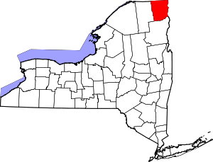 | |
| Towns | ||
| Villages | ||
| CDPs | ||
| Other hamlets | ||
| Footnotes | ‡This populated place also has portions in an adjacent county or counties | |
Municipalities and communities of Essex County, New York, United States | ||
|---|---|---|
| Towns | 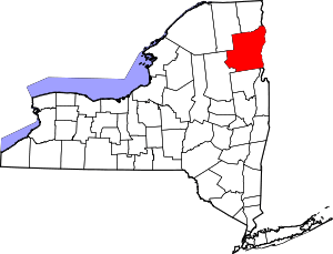 | |
| Villages | ||
| CDPs | ||
| Other hamlets | ||
| Footnotes | ‡This populated place also has portions in an adjacent county or counties | |