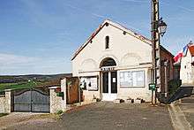
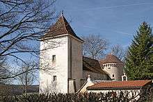
Barjon
| Barjon | ||
|---|---|---|
 | ||
| ||
 Barjon | ||
|
Location within Bourgogne-Franche-Comté region  Barjon | ||
| Coordinates: 47°36′45″N 4°57′34″E / 47.6125°N 4.9594°ECoordinates: 47°36′45″N 4°57′34″E / 47.6125°N 4.9594°E | ||
| Country | France | |
| Region | Bourgogne-Franche-Comté | |
| Department | Côte-d'Or | |
| Arrondissement | Dijon | |
| Canton | Grancey-le-Château-Neuvelle | |
| Intercommunality | CCST | |
| Government | ||
| • Mayor (2001–2020) | Alain Guyot | |
| Area1 | 4.57 km2 (1.76 sq mi) | |
| Population (2012)2 | 36 | |
| • Density | 7.9/km2 (20/sq mi) | |
| Time zone | CET (UTC+1) | |
| • Summer (DST) | CEST (UTC+2) | |
| INSEE/Postal code | 21049 / 21580 | |
| Elevation |
333–467 m (1,093–1,532 ft) (avg. 456 m or 1,496 ft) | |
|
1 French Land Register data, which excludes lakes, ponds, glaciers > 1 km² (0.386 sq mi or 247 acres) and river estuaries. 2 Population without double counting: residents of multiple communes (e.g., students and military personnel) only counted once. | ||
Barjon is a French commune in the Côte-d'Or department in the Bourgogne-Franche-Comté region of eastern France.[1]
The inhabitants of the commune are known as .[2]
Geography
Barjon is located on the southern flank of Mont Mercure (469 m) at an altitude of 397 metres at the town hall. It is some 40 km south-west of Langres and 40 km north by north-west of Dijon. Access to the commune is by the D19 road from Salives in the west which passes through the village and continues east to Avot. The D19E goes north from the village to join the D190 on the northern border of the commune.
The commune is forested in the southern arm with the centre of the commune farmland and a band of forest around its borders.
La Tille stream forms the south-western border of the commune as it flows east across the "neck" of the commune then forms part of the eastern border before continuing east to join La Creuse at Avot. La Tille de Barjon rises just east of the commune and flows south near the eastern border to join La Tille. Le Volgrain stream rises north-west of the commune and flows south down the western side of the commune and joins La Tille just south-west of the village.[3][4]
Mapping
A list of online mapping systems can be displayed by clicking on the coordinates (latitude and longitude) in the top right hand corner of this article.
Neighbouring communes and villages
 |
Fraignot-et-Vesvrotte | Courlon | | |
| Salives | |
Avot | ||
| ||||
| | ||||
| Le Meix | Poiseul-lès-Saulx | Avelanges |

History
After the raids by the Saracens on Autun and the sacking of the village by Anbasa ibn Suhaym Al-Kalbi on 22 August 725, Saint Frodulphe de Barjon, the Abbot of Saint Martin, retired as a hermit to Barjon.
Barjon appears as Barjon on the 1750 Cassini Map[5] and the same on the 1790 version.[6]
Heraldry
 |
The official status of the blazon remains to be determined.
Blazon: |
Administration
| From | To | Name | Party | Position |
|---|---|---|---|---|
| 2001 | 2020 | Alain Guyot |
(Not all data is known)
Demography
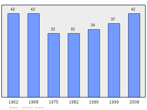
In 2010 the commune had 41 inhabitants. The evolution of the number of inhabitants is known from the population censuses conducted in the commune since 1793. From the 21st century, a census of communes with fewer than 10,000 inhabitants is held every five years, unlike larger communes that have a sample survey every year.[Note 1]
| 1793 | 1800 | 1806 | 1821 | 1831 | 1836 | 1841 | 1846 | 1851 |
|---|---|---|---|---|---|---|---|---|
| 270 | 210 | 230 | 168 | 208 | 215 | 184 | 152 | 173 |
| 1856 | 1861 | 1866 | 1872 | 1876 | 1881 | 1886 | 1891 | 1896 |
|---|---|---|---|---|---|---|---|---|
| 160 | 157 | 146 | 123 | 103 | 84 | 82 | 82 | 64 |
| 1901 | 1906 | 1911 | 1921 | 1926 | 1931 | 1936 | 1946 | 1954 |
|---|---|---|---|---|---|---|---|---|
| 68 | 61 | 65 | 59 | 60 | 73 | 63 | 66 | 55 |
| 1962 | 1968 | 1975 | 1982 | 1990 | 1999 | 2006 | 2010 | - |
|---|---|---|---|---|---|---|---|---|
| 42 | 42 | 32 | 32 | 34 | 37 | 41 | - |
Sources : Ldh/EHESS/Cassini until 1962, INSEE database from 1968 (population without double counting and municipal population from 2006)
Culture and heritage
Religious heritage
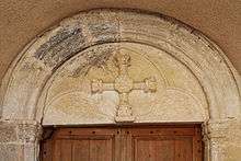
The commune has a Cemetery Cross (15th century)![]() which is registered as an historical monument.[8]
which is registered as an historical monument.[8]

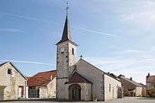
The Church contains several items that are registered as historical objects:
- A Statue: Saint John the Evangelist (17th century)
 [9]
[9] - A Statue: Saint Madeleine (16th century)[10]
- A Group Sculpture: Virgin of Pity (17th century)[11]
- The Sarcophagus of Saint Frodulphe (8th century)[12]
- A Statue: Saint Benigne (15th century)[13]
- A Shrine to Saint Frodulphe (17th century)[14]
- A Shrine to Saint Frodulphe (17th century)[15]
- A Statue: Saint Roch (17th century)[16]
- A Statue: Saint Frodulphe (17th century)[17]
See also
Notes and references
Notes
- ↑ At the beginning of the 21st century, the methods of identification have been modified by Law No. 2002-276 of 27 February 2002, the so-called "law of local democracy" and in particular Title V "census operations" allows, after a transitional period running from 2004 to 2008, the annual publication of the legal population of the different French administrative districts. For communes with a population greater than 10,000 inhabitants, a sample survey is conducted annually and the entire territory of these communes is taken into account at the end of the period of five years. The first "legal population" after 1999 under this new law came into force on 1 January 2009 and was based on the census of 2006.
References
- ↑ Barjon on Lion1906
- ↑ Inhabitants of Côte-d'Or (French)
- 1 2 Barjon on Google Maps
- ↑ Barjon on the Géoportail from National Geographic Institute (IGN) website (French)
- ↑ Barjon on the 1750 Cassini Map
- ↑ Barjon on the 1790 Cassini Map
- ↑ List of Mayors of France (French)
- ↑ Ministry of Culture, Mérimée PA00112095 Cross (French)
- ↑ Ministry of Culture, Palissy PM21002634 Statue: Saint John the Evangelist
 (French)
 - ↑ Ministry of Culture, Palissy PM21000178 Statue: Saint Madeleine
(French)
- ↑ Ministry of Culture, Palissy PM21000177 Group Sculpture: Virgin of Pity
(French)
- ↑ Ministry of Culture, Palissy PM21000176 Sarcophagus of Saint Frodulphe (French)
- ↑ Ministry of Culture, Palissy PM21002633 Statue: Saint Benigne
(French)
- ↑ Ministry of Culture, Palissy PM21000175 Shrine to Saint Frodulphe
(French)
- ↑ Ministry of Culture, Palissy PM21000174 Shrine to Saint Frodulphe
(French)
- ↑ Ministry of Culture, Palissy PM21000173 Statue: Saint Roch
(French)
- ↑ Ministry of Culture, Palissy PM21000172 Statue: Saint Frodulphe
(French)
| Wikimedia Commons has media related to Barjon. |