Bard-le-Régulier
| Bard-le-Régulier | |
|---|---|
 | |
 Bard-le-Régulier | |
|
Location within Bourgogne-Franche-Comté region  Bard-le-Régulier | |
| Coordinates: 47°08′47″N 4°19′01″E / 47.1464°N 4.3169°ECoordinates: 47°08′47″N 4°19′01″E / 47.1464°N 4.3169°E | |
| Country | France |
| Region | Bourgogne-Franche-Comté |
| Department | Côte-d'Or |
| Arrondissement | Beaune |
| Canton | Liernais |
| Intercommunality | Liernais |
| Government | |
| • Mayor (2001–2020) | Raymond Morel |
| Area1 | 9.1 km2 (3.5 sq mi) |
| Population (2010)2 | 70 |
| • Density | 7.7/km2 (20/sq mi) |
| Time zone | CET (UTC+1) |
| • Summer (DST) | CEST (UTC+2) |
| INSEE/Postal code | 21046 / 21430 |
| Elevation |
394–550 m (1,293–1,804 ft) (avg. 450 m or 1,480 ft) |
|
1 French Land Register data, which excludes lakes, ponds, glaciers > 1 km² (0.386 sq mi or 247 acres) and river estuaries. 2 Population without double counting: residents of multiple communes (e.g., students and military personnel) only counted once. | |
Bard-le-Régulier is a French commune in the Côte-d'Or department in the Bourgogne-Franche-Comté region of eastern France.[1]
The inhabitants of the commune are known as Barriens or Barriennes.[2]
Geography
Bard-le-Régulier is located in the Massif of Morvan in a natural regional park at the foot of Mount Bard some 60 km south-west of Dijon, 25 km north of Autun, and 12 km west of Arnay-le-Duc. Access to the commune is by the D15 road from Brazey-en-Morvan in the north which passes through the heart of the commune and the village before continuing south to join the D11 south of Manlay. The D15E goes north-east from the village to Vianges. The D115 goes south-west from the village to join the D233 south-west of the commune after changing to the D247 at the departmental border. A railway line passes through the commune from north to south but there is no station in the commune with the nearest station some 2 km south-east of the commune. The commune is quite heavily forested but with large areas of farmland.[3][4]
The Trévoux rises from a small lake in the north of the commune and flows south through the village continuing south to eventually join the Arroux north-west of Igornay.[3]
Mapping
A list of online mapping systems can be displayed by clicking on the coordinates (latitude and longitude) in the top right hand corner of this article. None of these maps, however, show the extent of nor any information on the commune.
Neighbouring communes and villages[3]
 |
Blanot | Brazey-en-Morvan | Vianges | |
| Villiers-en-Morvan | |
Marcheseuil | ||
| ||||
| | ||||
| Manlay |
History
Bard-le-Régulier appears as Bard on the 1750 Cassini Map[5] and does not appear on the 1790 version.[6]
Administration
| From | To | Name | Party | Position |
|---|---|---|---|---|
| 2001 | 2020 | Raymond Morel |
(Not all data is known)
Demography
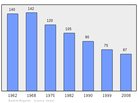
In 2010 the commune had 70 inhabitants. The evolution of the number of inhabitants is known from the population censuses conducted in the commune since 1793. From the 21st century, a census of communes with fewer than 10,000 inhabitants is held every five years, unlike larger communes that have a sample survey every year.[Note 1]
| 1793 | 1800 | 1806 | 1821 | 1831 | 1836 | 1841 | 1846 | 1851 |
|---|---|---|---|---|---|---|---|---|
| 301 | 313 | 293 | 254 | 268 | 238 | 301 | 281 | 290 |
| 1856 | 1861 | 1866 | 1872 | 1876 | 1881 | 1886 | 1891 | 1896 |
|---|---|---|---|---|---|---|---|---|
| 305 | 273 | 299 | 299 | 300 | 314 | 278 | 296 | 293 |
| 1901 | 1906 | 1911 | 1921 | 1926 | 1931 | 1936 | 1946 | 1954 |
|---|---|---|---|---|---|---|---|---|
| 260 | 229 | 230 | 192 | 188 | 185 | 202 | 210 | 153 |
| 1962 | 1968 | 1975 | 1982 | 1990 | 1999 | 2006 | 2010 | - |
|---|---|---|---|---|---|---|---|---|
| 140 | 142 | 120 | 105 | 90 | 75 | 66 | 70 | - |
Sources : Ldh/EHESS/Cassini until 1962, INSEE database from 1968 (population without double counting and municipal population from 2006)
Culture and heritage
Civil heritage
The commune has a number of sites that are registered as historical monuments:
- A Farmhouse on the D115 (19th century)
 [8]
[8] - A Farmhouse on the D115 (19th century)[9]
- Houses and Farms (16th-19th century)[10]
Religious heritage
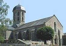
- The Church of Saint John the Evangelist (11th century) is registered as an historical monument.[11] The Church is surmounted by an octagonal bell tower which was built in the 11th to the 14th centuries. It depended on the priory of the Canons Regular of Saint Augustine. The Church contains several items that are registered as historical objects:
- Church Picture Gallery
-

The Bell Tower
-
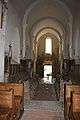
The nave
-

The Altar Table (12th century)
-
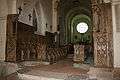
The Stalls (14th century)
-

A detail on the Stalls
-

A detail on the Stalls
See also
Notes and references
Notes
- ↑ At the beginning of the 21st century, the methods of identification have been modified by Law No. 2002-276 of 27 February 2002, the so-called "law of local democracy" and in particular Title V "census operations" allows, after a transitional period running from 2004 to 2008, the annual publication of the legal population of the different French administrative districts. For communes with a population greater than 10,000 inhabitants, a sample survey is conducted annually, the entire territory of these communes is taken into account at the end of the period of five years. The first "legal population" after 1999 under this new law came into force on 1 January 2009 and was based on the census of 2006.
References
- ↑ Bard-le-Régulier on Lion1906
- ↑ Inhabitants of Côte-d'Or (French)
- 1 2 3 Bard-le-Régulier on Google Maps
- ↑ Bard-le-Régulier on the Géoportail from National Geographic Institute (IGN) website (French)
- ↑ Bard on the 1750 Cassini Map
- ↑ Blank on the 1790 Cassini Map
- ↑ List of Mayors of France (French)
- ↑ Ministry of Culture, Mérimée IA21000737 Farmhouse (French)
- ↑ Ministry of Culture, Mérimée IA21000736 Farmhouse (French)
- ↑ Ministry of Culture, Mérimée IA21000735 Houses and Farms (French)
- ↑ Ministry of Culture, Mérimée PA00112096 Church of Saint John the Evangelist (French)

- ↑ Ministry of Culture, Palissy PM21002965 Altar
(French)
- ↑ Ministry of Culture, Palissy PM21000170 Altar Table
(French)
- ↑ Ministry of Culture, Palissy PM21000169 Statiue: Saint Sebastian
(French)
- ↑ Ministry of Culture, Palissy PM21000168 Statue: Saint John the Evangelist drinking the poisoned cup (French)
- ↑ Ministry of Culture, Palissy PM21000167 Sculpture: Jean Brazey reclining (French)
- ↑ Ministry of Culture, Palissy PM21000166 Upper and Lower Stalls (French)
| Wikimedia Commons has media related to Bard-le-Régulier. |