Morey-Saint-Denis
| Morey-Saint-Denis | |
|---|---|
 | |
 Morey-Saint-Denis | |
|
Location within Bourgogne-Franche-Comté region  Morey-Saint-Denis | |
| Coordinates: 47°11′47″N 4°57′51″E / 47.1964°N 4.9642°ECoordinates: 47°11′47″N 4°57′51″E / 47.1964°N 4.9642°E | |
| Country | France |
| Region | Bourgogne-Franche-Comté |
| Department | Côte-d'Or |
| Arrondissement | Dijon |
| Canton | Gevrey-Chambertin |
| Intercommunality | Gevrey-Chambertin |
| Government | |
| • Mayor (2008–2014) | Gérad Tardy |
| Area1 | 7.83 km2 (3.02 sq mi) |
| Population (2008)2 | 687 |
| • Density | 88/km2 (230/sq mi) |
| Time zone | CET (UTC+1) |
| • Summer (DST) | CEST (UTC+2) |
| INSEE/Postal code | 21442 / 21220 |
| Elevation | 222–472 m (728–1,549 ft) |
|
1 French Land Register data, which excludes lakes, ponds, glaciers > 1 km² (0.386 sq mi or 247 acres) and river estuaries. 2 Population without double counting: residents of multiple communes (e.g., students and military personnel) only counted once. | |
Morey-Saint-Denis is a commune in the Côte-d'Or department in eastern France.
Population
| Historical population | ||
|---|---|---|
| Year | Pop. | ±% |
| 1962 | 664 | — |
| 1968 | 740 | +11.4% |
| 1975 | 718 | −3.0% |
| 1982 | 653 | −9.1% |
| 1990 | 639 | −2.1% |
| 1999 | 673 | +5.3% |
| 2008 | 687 | +2.1% |
Wine
Main article: Morey-Saint-Denis wine
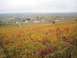
Morey-Saint-Denis is situated in the Northern section of the Côte d'Or called Côte de Nuits. It is one of the principal wine producing villages of the region.
Within Morey-Saint-Denis there are five Grand Cru appellations and 20 Premier Cru vineyards. The Bonnes Mares appellation straddles the border between Morey-Saint-Denis and Chambolle-Musigny and therefore can be produced in either commune .
Grand Cru appellations
Premier Cru vineyards
- Les Genavrières
- Monts Luisants
- Les Chaffots
- Clos Baulet
- Les Blanchards
- Les Gruenchers
- La Riotte
- Les Millandes
- Les Faconnières
- Les Charrières
- Clos des Ormes
- Aux Charmes
- Aux Cheseaux
- Les Chenevery
- Le Village
- Les Sorbés
- Clos Sorbé
- La Bussière
- Les Ruchots
See also
References
| Wikimedia Commons has media related to Morey-Saint-Denis. |
This article is issued from Wikipedia - version of the 6/23/2016. The text is available under the Creative Commons Attribution/Share Alike but additional terms may apply for the media files.