Barker, Uruguay
| Barker | |
|---|---|
| Village | |
 Barker Location within Uruguay | |
| Coordinates: 34°16′0″S 57°28′0″W / 34.26667°S 57.46667°W | |
| Country |
|
| Department | Colonia Department |
| Population (2011) | |
| • Total | 158 |
| Time zone | UTC -3 |
| Postal code | 70007 |
| Dial plan | +598 45 (+6 digits) |
Barker (Spanish pronunciation: [barˈker]) is a small village located in the Colonia Department of southwestern Uruguay.
Location
Barker is located along Route 54. Its nearest populated places are Rosario, to the southeast and Tarariras, to the west. Near the town it is the stream Arroyo Minuano and the hills Cuchilla del Minuano and Cuchilla del Colla.
History
Barker was originally established as a small British settlement in Uruguay.
Population
According to the 2011 census, Barker had a population of 158.[1]
| Year | Population |
|---|---|
| 1963 | 171 |
| 1975 | 113 |
| 1985 | 91 |
| 1996 | 68 |
| 2004 | 91 |
| 2011 | 158 |
Source: Instituto Nacional de Estadística de Uruguay[2]
References
- ↑ "Censos 2011 Colonia (needs flash plugin)". ΙΝΕ. 2012. Archived from the original on 1 September 2012. Retrieved 30 August 2012.
- ↑ "1963–1996 Statistics / B" (DOC). Instituto Nacional de Estadística de Uruguay. 2004. Archived from the original on 21 July 2011. Retrieved 28 June 2011.
External links
Capital: Colonia del Sacramento | ||
| Towns and villages | 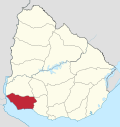 | |
| Sights | ||
This article is issued from Wikipedia - version of the 10/27/2016. The text is available under the Creative Commons Attribution/Share Alike but additional terms may apply for the media files.