Beaver, West Virginia
| Beaver, West Virginia | |
|---|---|
| Census-designated place (CDP) | |
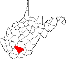
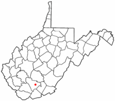 Location of Beaver, West Virginia | |
| Coordinates: 37°44′51″N 81°8′31″W / 37.74750°N 81.14194°WCoordinates: 37°44′51″N 81°8′31″W / 37.74750°N 81.14194°W | |
| Country | United States |
| State | West Virginia |
| County | Raleigh |
| Area | |
| • Total | 4.4 sq mi (11.4 km2) |
| • Land | 4.4 sq mi (11.4 km2) |
| • Water | 0.0 sq mi (0.0 km2) |
| Elevation | 2,156 ft (657 m) |
| Population (2010)[1] | |
| • Total | 1,308 |
| • Density | 300/sq mi (110/km2) |
| Time zone | Eastern (EST) (UTC-5) |
| • Summer (DST) | EDT (UTC-4) |
| ZIP code | 25813 |
| Area code(s) | 304 |
| FIPS code | 54-05260[2] |
| GNIS feature ID | 1553828[3] |
Beaver is a census-designated place (CDP) in Raleigh County, West Virginia, USA. The population was 1,308 at the 2010 census.[1]
Name
Beaver first acquired its name around 1860 “from the great numbers of beavers abounding in the creeks during the early days of settlement”, according to A History of Shady Spring District (1979) compiled by the Shady Spring District Woman’s Club. When the community became eligible for a post office in the early 1900s, the residents discovered another West Virginia town already had the name. The town adopted the name “Oxley”, after a Huntington man who ran a clothing store there. In 1929 or '30, Grover Hedrick bought Ritter Lumber Company and had the community name changed to “Glen Hedrick.” The residents petitioned the federal government for another name change and finally, the community was officially named Beaver in 1939.
Geography
Beaver is located at 37°44′51″N 81°8′31″W / 37.74750°N 81.14194°W (37.747601, -81.141843).[4]
According to the United States Census Bureau, the CDP has a total area of 4.4 square miles (11.4 km²), of which, 4.4 square miles (11.4 km²) of it is land and 0.23% is water.
Demographics
As of the census[2] of 2000, there were 1,378 people, 602 households, and 388 families residing in the CDP. The population density was 313.7 people per square mile (121.2/km²). There were 696 housing units at an average density of 158.4/sq mi (61.2/km²). The racial makeup of the CDP was 98.77% White, 0.07% African American, 0.15% Native American, 0.94% Asian, and 0.07% from two or more races. Hispanic or Latino of any race were 0.51% of the population.
There were 602 households out of which 25.6% had children under the age of 18 living with them, 51.3% were married couples living together, 10.6% had a female householder with no husband present, and 35.4% were non-families. 30.1% of all households were made up of individuals and 13.5% had someone living alone who was 65 years of age or older. The average household size was 2.26 and the average family size was 2.81.
In the CDP the population was spread out with 21.8% under the age of 18, 9.8% from 18 to 24, 27.2% from 25 to 44, 25.7% from 45 to 64, and 15.5% who were 65 years of age or older. The median age was 39 years. For every 100 females there were 91.4 males. For every 100 females age 18 and over, there were 88.9 males.
The median income for a household in the CDP was $25,863, and the median income for a family was $32,083. Males had a median income of $35,156 versus $16,836 for females. The per capita income for the CDP was $16,694. About 9.2% of families and 16.6% of the population were below the poverty line, including 20.6% of those under age 18 and 10.0% of those age 65 or over.
References
- 1 2 "American FactFinder". United States Census Bureau. Archived from the original on 2013-09-11. Retrieved 2011-05-14.
- 1 2 "American FactFinder". United States Census Bureau. Archived from the original on 2013-09-11. Retrieved 2008-01-31.
- ↑ "US Board on Geographic Names". United States Geological Survey. 2007-10-25. Retrieved 2008-01-31.
- ↑ "US Gazetteer files: 2010, 2000, and 1990". United States Census Bureau. 2011-02-12. Retrieved 2011-04-23.