Glen White, West Virginia
| Glen White, West Virginia | |
|---|---|
| Census-designated place (CDP) | |
 Glen White, West Virginia | |
| Coordinates: 37°43′49″N 81°16′47″W / 37.73028°N 81.27972°WCoordinates: 37°43′49″N 81°16′47″W / 37.73028°N 81.27972°W | |
| Country | United States |
| State | West Virginia |
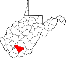
| County | Raleigh |
| Area[1] | |
| • Total | 0.506 sq mi (1.31 km2) |
| • Land | 0.506 sq mi (1.31 km2) |
| • Water | 0 sq mi (0 km2) |
| Elevation | 2,155 ft (657 m) |
| Population (2010)[2] | |
| • Total | 266 |
| • Density | 530/sq mi (200/km2) |
| Time zone | Eastern (EST) (UTC-5) |
| • Summer (DST) | EDT (UTC-4) |
| ZIP code | 25849 |
| Area code(s) | 304 & 681 |
| GNIS feature ID | 1554570[3] |
Glen White is a census-designated place (CDP) in Raleigh County, West Virginia, United States. Glen White is located on West Virginia Route 54 and West Virginia Route 97 1 mile (1.6 km) southeast of Lester. Glen White has a post office with ZIP code 25849.[4] As of the 2010 census, its population is 266.[2]
The community derives its name from E. E. White, the proprietor of a local coal mine.[5]
References
- ↑ "US Gazetteer files: 2010, 2000, and 1990". United States Census Bureau. 2011-02-12. Retrieved 2011-04-23.
- 1 2 "American FactFinder". United States Census Bureau. Retrieved 2011-05-14.
- ↑ U.S. Geological Survey Geographic Names Information System: Glen White, West Virginia
- ↑ ZIP Code Lookup
- ↑ Kenny, Hamill (1945). West Virginia Place Names: Their Origin and Meaning, Including the Nomenclature of the Streams and Mountains. Piedmont, WV: The Place Name Press. p. 275.
This article is issued from Wikipedia - version of the 9/5/2016. The text is available under the Creative Commons Attribution/Share Alike but additional terms may apply for the media files.