Belgique, Missouri
| Belgique, Missouri | |
|---|---|
| unincorporated community | |
|
Belgique, Missouri, roadsign | |
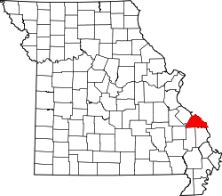 Location of Perry County, Missouri | |
| Coordinates: 37°50′15″N 89°46′52″W / 37.83750°N 89.78111°WCoordinates: 37°50′15″N 89°46′52″W / 37.83750°N 89.78111°W | |
| Country | United States |
| State | Missouri |
| County | Perry |
| Township | Bois Brule [1] |
| Elevation | 372 ft (113 m) |
| Time zone | Central (CST) (UTC-6) |
| • Summer (DST) | CDT (UTC-5) |
| ZIP code | 63775 |
| Area code(s) | 573 |
| FIPS code | 29-04042 [2] |
| GNIS feature ID | 713893 [2] |

Belgique is an unincorporated community in eastern Perry County, Missouri, United States. It is located about five miles south of Chester, Illinois in Perry County's Bois Brule Township.
Name
Since a town already existed in Missouri by the name of Belgium, the Flemish residents opted to use the French name for their homeland.
History
The town was originally settled by Catholic Flemings from Belgium. A Catholic church, The Nativity of the Blessed Virgin Mary, existed in Belgique from 1884 to 1992.[3] A post office was established in 1890, but as the name "Belgium" had already been taken, the French name for Belgium "Belgique" was used instead.[4] Its post office has closed and its mail now comes from Perryville.[5] Since the flood of 1993 there is no longer an existing town.[6]
Floods
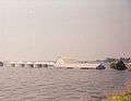
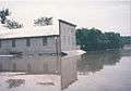
Of the many floods over the centuries, most devastating flood was the Great Flood of 1993. The subsequent flood destroyed the village, leaving only a handful of residents to return to the area following the flood.[7][8]
-
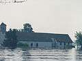
Flooded Church - Nativity of the Blessed Virgin Mary
-
Flooded farm
-
Flooded store
Geography
Belgique is located on the flat alluvial plain of the Bois Brule Bottom situated in the northern part of Perry County.
Gallery
-
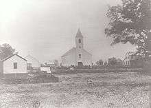
Belgique, 19th century
See also
References
- ↑ Histopolis
- 1 2 Roadside Thoughts
- ↑ Missouri Historical Society: Perry County Place Names, 1928-1945
- ↑ Flemish Genealogy
- ↑ Missouri Postal History
- ↑ Nativity Cemetery - Perry County, Missouri Archived November 4, 2013, at the Wayback Machine.
- ↑ Erin Ragan (August 14, 2013). "Remembering the 1993 flood: Locals look back at flood fight". Southeast Missourian.
- ↑ US Army Corps of Engineers (December 1993). "Upper Mississippi River Basin Flood of 1993, Flood-Fight Reconnaissance and Survey of Expedient Methods Employed".
Municipalities and communities of Perry County, Missouri, United States | ||
|---|---|---|
| Cities | | |
| Villages | ||
| Townships | ||
| CDP | ||
| Other unincorporated communities | ||
| Abandoned villages | ||
| Footnotes | ‡This populated place also has portions in an adjacent county or counties | |