Frohna, Missouri
| Frohna, Missouri | |
|---|---|
| Village | |
|
Frohna, Missouri, road sign | |
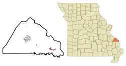 Location of Frohna, Missouri | |
| Coordinates: 37°38′26″N 89°37′9″W / 37.64056°N 89.61917°WCoordinates: 37°38′26″N 89°37′9″W / 37.64056°N 89.61917°W | |
| Country | United States |
| State | Missouri |
| County | Perry |
| Township | Brazeau |
| Area[1] | |
| • Total | 0.90 sq mi (2.33 km2) |
| • Land | 0.90 sq mi (2.33 km2) |
| • Water | 0 sq mi (0 km2) |
| Elevation | 587 ft (179 m) |
| Population (2010)[2] | |
| • Total | 254 |
| • Estimate (2012[3]) | 257 |
| • Density | 282.2/sq mi (109.0/km2) |
| Time zone | Central (CST) (UTC-6) |
| • Summer (DST) | CDT (UTC-5) |
| ZIP code | 63748 |
| Area code(s) | 573 |
| FIPS code | 29-26092[4] |
| GNIS feature ID | 0736298[5] |

Frohna /ˈfroʊnə/ is a city in Perry County, Missouri, United States. The population was 254 at the 2010 census.
Name
Frohna is named after the town of Niederfrohna[6] (German: Lower Frohna) in the Zwickau district of the German region of Saxony. Although the German colony was initially called Niederfrohna, the Nieder- was eventually dropped from the name.
History
Frohna is one of seven towns and villages in the area founded by German immigrants in 1839. It and the others -- Altenburg, Dresden, Johannisberg, Paitzdorf, Seelitz, and Wittenberg—were all named by settlers for towns in the Saxony region of their native country.[7]
Community
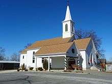
Concordia Lutheran Church is a member of the Lutheran Church-Missouri Synod. The Saxon Fall Festival is held every October at the Saxon Lutheran Memorial.[8]
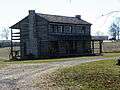
Saxon Lutheran Memorial
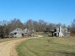
The Saxon Lutheran Memorial is a tribute to the German Lutheran migration of 1838/1839, and features a number of log cabins from that era.[9]
Geography
Frohna is located at 37°38′26″N 89°37′9″W / 37.64056°N 89.61917°W (37.640590, -89.619192).[10]
According to the United States Census Bureau, the city has a total area of 0.90 square miles (2.33 km2), all land.[1]
Nearby communities
Demographics
| Historical population | |||
|---|---|---|---|
| Census | Pop. | %± | |
| 1880 | 97 | — | |
| 1950 | 208 | — | |
| 1960 | 216 | 3.8% | |
| 1970 | 225 | 4.2% | |
| 1980 | 265 | 17.8% | |
| 1990 | 162 | −38.9% | |
| 2000 | 192 | 18.5% | |
| 2010 | 254 | 32.3% | |
| Est. 2015 | 258 | [11] | 1.6% |
2010 census
As of the census[2] of 2010, there were 254 people, 102 households, and 74 families residing in the city. The population density was 282.2 inhabitants per square mile (109.0/km2). There were 115 housing units at an average density of 127.8 per square mile (49.3/km2). The racial makeup of the city was 99.61% White and 0.39% Native American.
There were 102 households of which 34.3% had children under the age of 18 living with them, 63.7% were married couples living together, 7.8% had a female householder with no husband present, 1.0% had a male householder with no wife present, and 27.5% were non-families. 25.5% of all households were made up of individuals and 13.7% had someone living alone who was 65 years of age or older. The average household size was 2.49 and the average family size was 3.03.
The median age in the city was 39.7 years. 26% of residents were under the age of 18; 7% were between the ages of 18 and 24; 26% were from 25 to 44; 24% were from 45 to 64; and 16.9% were 65 years of age or older. The gender makeup of the city was 51.6% male and 48.4% female.
2000 census
As of the census[4] of 2000, there were 192 people, 84 households, and 51 families residing in the city. The population density was 327.3 people per square mile (125.6/km²). There were 91 housing units at an average density of 155.1 per square mile (59.6/km²). The racial makeup of the city was 99.48% White, and 0.52% from two or more races.
There were 84 households out of which 26.2% had children under the age of 18 living with them, 57.1% were married couples living together, 2.4% had a female householder with no husband present, and 38.1% were non-families. 33.3% of all households were made up of individuals and 17.9% had someone living alone who was 65 years of age or older. The average household size was 2.29 and the average family size was 2.96.
In the city the population was spread out with 20.8% under the age of 18, 7.8% from 18 to 24, 25.5% from 25 to 44, 21.9% from 45 to 64, and 24.0% who were 65 years of age or older. The median age was 40 years. For every 100 females there were 115.7 males. For every 100 females age 18 and over, there were 92.4 males.
The median income for a household in the city was $41,635, and the median income for a family was $51,250. Males had a median income of $33,125 versus $20,357 for females. The per capita income for the city was $17,400. About 1.8% of families and 7.0% of the population were below the poverty line, including 8.0% of those under the age of eighteen and 22.0% of those sixty five or over.
Gallery
 Saxon Lutheran Memorial
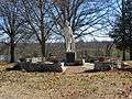 Carl Ferdinand Wilhelm Walther statue
 Saxon Memorial
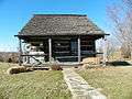 Saxon Lutheran Memorial cabin
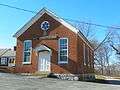 die kleine Schule
 Watertower
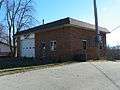 City Hall
References
- 1 2 "US Gazetteer files 2010". United States Census Bureau. Retrieved 2012-07-08.
- 1 2 "American FactFinder". United States Census Bureau. Retrieved 2012-07-08.
- ↑ "Population Estimates". United States Census Bureau. Retrieved 2013-05-30.
- 1 2 "American FactFinder". United States Census Bureau. Retrieved 2008-01-31.
- ↑ "US Board on Geographic Names". United States Geological Survey. 2007-10-25. Retrieved 2008-01-31.
- ↑ Earngey, Bill (1995). Missouri Roadsides: The Traveler's Companion. University of Missouri Press. p. 95.
- ↑ McMillen, Margot Ford (1994). Paris, Tightwad and Peculiar: Missouri Place Names. Columbia, Missouri: University of Missouri Press. pp. 55–56. ISBN 0-8262-0972-6.
- ↑ Pcmutual.com http://www.pcmutual.com/calender.htm
- ↑ Visitors Guide to the Saxon Lutheran Memorial http://www.greatriverroad.com/meetohio/saxonmemorial.htm
- ↑ "US Gazetteer files: 2010, 2000, and 1990". United States Census Bureau. 2011-02-12. Retrieved 2011-04-23.
- ↑ "Annual Estimates of the Resident Population for Incorporated Places: April 1, 2010 to July 1, 2015". Retrieved July 2, 2016.
- ↑ "Census of Population and Housing". Census.gov. Retrieved June 4, 2015.
| Wikimedia Commons has media related to Frohna, Missouri. |
Municipalities and communities of Perry County, Missouri, United States | ||
|---|---|---|
| Cities | 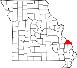 | |
| Villages | ||
| Townships | ||
| CDP | ||
| Other unincorporated communities | ||
| Abandoned villages | ||
| Footnotes | ‡This populated place also has portions in an adjacent county or counties | |