Berkey, Ohio
| Berkey, Ohio | |
|---|---|
| Village | |
|
Village Hall | |
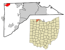 Location in Lucas County and the state of Ohio. | |
| Coordinates: 41°42′52″N 83°50′0″W / 41.71444°N 83.83333°WCoordinates: 41°42′52″N 83°50′0″W / 41.71444°N 83.83333°W | |
| Country | United States |
| State | Ohio |
| County | Lucas |
| Area[1] | |
| • Total | 4.18 sq mi (10.83 km2) |
| • Land | 4.18 sq mi (10.83 km2) |
| • Water | 0 sq mi (0 km2) |
| Elevation[2] | 699 ft (213 m) |
| Population (2010)[3] | |
| • Total | 237 |
| • Estimate (2012[4]) | 235 |
| • Density | 56.7/sq mi (21.9/km2) |
| Time zone | Eastern (EST) (UTC-5) |
| • Summer (DST) | EDT (UTC-4) |
| ZIP code | 43504 |
| Area code(s) | 419 |
| FIPS code | 39-05732[5] |
| GNIS feature ID | 1064417[2] |
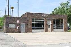
Berkey is a village in Lucas County, Ohio, United States. The population was 237 at the 2010 census.
History
Berkey was originally called Riga.[6] The present name is derived from Richard K. Berkeybile, an early postmaster.[6] A post office called Riga was established in 1837, and the name was changed to Berkey in 1870.[7]
Geography
Berkey is located at 41°42′52″N 83°50′0″W / 41.71444°N 83.83333°W (41.714400, -83.833392).[8]
According to the United States Census Bureau, the village has a total area of 4.18 square miles (10.83 km2), all land.[1]
Demographics
| Historical population | |||
|---|---|---|---|
| Census | Pop. | %± | |
| 1920 | 201 | — | |
| 1930 | 261 | 29.9% | |
| 1940 | 248 | −5.0% | |
| 1950 | 239 | −3.6% | |
| 1960 | 257 | 7.5% | |
| 1970 | 294 | 14.4% | |
| 1980 | 306 | 4.1% | |
| 1990 | 264 | −13.7% | |
| 2000 | 265 | 0.4% | |
| 2010 | 237 | −10.6% | |
| Est. 2015 | 237 | [9] | 0.0% |
2010 census
As of the census[3] of 2010, there were 237 people, 99 households, and 73 families residing in the village. The population density was 56.7 inhabitants per square mile (21.9/km2). There were 112 housing units at an average density of 26.8 per square mile (10.3/km2). The racial makeup of the village was 99.2% White and 0.8% Asian. Hispanic or Latino of any race were 1.3% of the population.
There were 99 households of which 28.3% had children under the age of 18 living with them, 63.6% were married couples living together, 9.1% had a female householder with no husband present, 1.0% had a male householder with no wife present, and 26.3% were non-families. 22.2% of all households were made up of individuals and 11.2% had someone living alone who was 65 years of age or older. The average household size was 2.39 and the average family size was 2.77.
The median age in the village was 48.2 years. 21.1% of residents were under the age of 18; 5% were between the ages of 18 and 24; 18.6% were from 25 to 44; 37.2% were from 45 to 64; and 18.1% were 65 years of age or older. The gender makeup of the village was 51.1% male and 48.9% female.
2000 census
As of the census[5] of 2000, there were 265 people, 98 households, and 81 families residing in the village. The population density was 63.5 people per square mile (24.5/km²). There were 100 housing units at an average density of 23.9 per square mile (9.2/km²). The racial makeup of the village was 98.11% White, 0.75% Native American, 0.38% Asian, and 0.75% from two or more races. Hispanic or Latino of any race were 0.38% of the population.
There were 98 households out of which 39.8% had children under the age of 18 living with them, 69.4% were married couples living together, 10.2% had a female householder with no husband present, and 17.3% were non-families. 15.3% of all households were made up of individuals and 8.2% had someone living alone who was 65 years of age or older. The average household size was 2.70 and the average family size was 3.04.
In the village the population was spread out with 29.4% under the age of 18, 3.8% from 18 to 24, 30.2% from 25 to 44, 25.3% from 45 to 64, and 11.3% who were 65 years of age or older. The median age was 37 years. For every 100 females there were 90.6 males. For every 100 females age 18 and over, there were 94.8 males.
The median income for a household in the village was $60,500, and the median income for a family was $65,313. Males had a median income of $46,000 versus $31,875 for females. The per capita income for the village was $25,944. None of the population or families were below the poverty line.
References
- 1 2 "US Gazetteer files 2010". United States Census Bureau. Archived from the original on 2012-07-14. Retrieved 2013-01-06.
- 1 2 "US Board on Geographic Names". United States Geological Survey. 2007-10-25. Retrieved 2008-01-31.
- 1 2 "American FactFinder". United States Census Bureau. Retrieved 2013-01-06.
- ↑ "Population Estimates". United States Census Bureau. Archived from the original on 2013-06-17. Retrieved 2013-06-17.
- 1 2 "American FactFinder". United States Census Bureau. Archived from the original on 2013-09-11. Retrieved 2008-01-31.
- 1 2 Stewart, Rose Russell (Mar 23, 1995). "Berkey seeking information about village's early history". Toledo Blade. pp. W5. Retrieved 21 January 2016.
- ↑ "Lucas County". Jim Forte Postal History. Retrieved 21 January 2016.
- ↑ "US Gazetteer files: 2010, 2000, and 1990". United States Census Bureau. 2011-02-12. Retrieved 2011-04-23.
- ↑ "Annual Estimates of the Resident Population for Incorporated Places: April 1, 2010 to July 1, 2015". Retrieved July 2, 2016.
- ↑ "Census of Population and Housing". Census.gov. Archived from the original on April 22, 2013. Retrieved June 4, 2015.
Municipalities and communities of Lucas County, Ohio, United States | ||
|---|---|---|
| Cities | 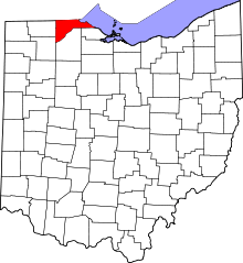 | |
| Villages | ||
| Townships | ||
| CDPs | ||
| Unincorporated communities |
| |
| Ghost town | ||
| Footnotes | ‡This populated place also has portions in an adjacent county or counties | |