Black Dome (New York)
- See Black Dome for other mountains of this name.
| Black Dome | |
|---|---|
|
Eastern side of Black Dome. | |
| Highest point | |
| Elevation | 3980+ ft, (1213+ m) NGVD 29[1] |
| Prominence | 2,060 ft (630 m) [1] |
| Listing | Catskill High Peaks |
| Coordinates | 42°16′12″N 74°07′21″W / 42.2700864°N 74.1226382°WCoordinates: 42°16′12″N 74°07′21″W / 42.2700864°N 74.1226382°W [2] |
| Geography | |
| Location | Greene County, New York |
| Parent range | Catskill Mountains |
| Topo map | USGS Freehold, NY |
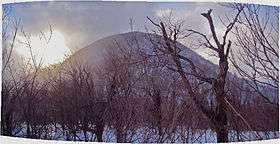
Black Dome is a mountain located in Greene County, New York. The mountain is the highest peak of the Blackhead Mountains range of the Catskills. Black Dome is flanked to the east by Blackhead, and to the west by Thomas Cole Mountain.
Black Dome stands within the watershed of Schoharie Creek, which drains into the Mohawk River, the Hudson River, and into New York Bay. The south side of Black Dome drains into East Kill, and thence into Schoharie Creek. The north side of Black Dome drains into Batavia Kill, and thence into Schoharie Creek.
Black Dome is within New York's Catskill Park.
See also
References
External links
- "Black Dome". Catskill 3500 Club. Archived from the original on 2008-04-13.
- "Black Dome". SummitPost.org.
| Northwest Catskills |   | |
|---|---|---|
| Blackhead Mountains | ||
| Other northeast Catskills | ||
| Devil's Path | ||
| Other central Catskills | ||
| Southwest Catskills | ||
| Burroughs Range | ||
| Other southern Catskills | ||
This article is issued from Wikipedia - version of the 11/3/2016. The text is available under the Creative Commons Attribution/Share Alike but additional terms may apply for the media files.