Blekinge archipelago
Blekinge archipelago is an archipelago in the Baltic Sea, located in Blekinge in the south of Sweden.
Geography
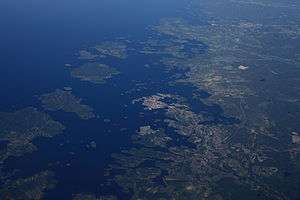
Blekinge archipelago stretches among almost the entire coastline of Blekinge, from west to east. It covers some 210,000 hectares (520,000 acres) including water; the landmass amounts to about 54,000 hectares (130,000 acres). The archipelago is dominated by a few large islands, Tjärö, Aspö, Hasslö, Tärnö and Sturkö, with smaller islands and skerries interspersed. In the whole archipelago area, some 85,000 people live, of which 4,000 are islanders.[1]
The landscape is a diverse cultural landscape, characterised by mainly a mix between oak pastures and deciduous forest. For its size, the archipelago exhibits an unusually high biodiversity. Endangered species who find a habitat in the archipelago include Osmoderma eremita and Lecanographa amylacea.[1]
Culture
The towns of Karlshamn and Karlskrona are both located within the archipelago area; indeed, Karlskrona is mainly situated on Trossö island. The latter, having been founded as a naval base, is noted for its Baroque architecture and listed as a UNESCO World Heritage Site.
Shipbuilding has been a traditional local trade within the archipelago and the area is known for a traditional type of small boat, called blekingeeka and used for tasks like fishing and transporting stone locally.[2]
In the 1970s, the local diving club discovered a shipwreck in the Blekinge archipelago that was eventually identified by archaeologists as Gribshunden, a 15th-century Danish warship.[3][4] The shipwreck is significant as one of the best-preserved wreckages from the early modern period.[3][5][6]
Gallery
-
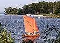
Blekingeeka, a type of small boat traditionally used in the archipelago area.
-
.JPG)
Typical landscape (Almö island)
-
.JPG)
Typical landscape (Almö island)
-
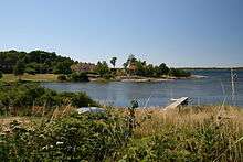
Typical landscape Aspö island
-
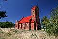
Church on Aspö island
References
- 1 2 "Blekinge Archipelago". Man and the Biosphere Programme. UNESCO. Retrieved 4 July 2013.
- ↑ "Världens farligaste blekingeeka". Marinumseum Karlskrona. Retrieved 4 July 2013.
- 1 2 Warming, Rolf (2015-07-01). "Gribshunden: Significance and Preliminary Investigations". Combat Archaeology. Retrieved 2015-08-13.
- ↑ Einarsson, Av Lars. "Ett skeppsvrak i Ronneby skärgård" [A shipwreck in the archipelago of Ronneby] (PDF) (in Swedish). Kalmar Läns Museum (Kalmar County Museum). Retrieved 2015-08-13.
- ↑ "Medieval ship's 'sea monster' figurehead raised from Baltic". BBC News. 2015-08-12. Retrieved 2015-08-13.
- ↑ Zolfagharifard, Ellie (2015-08-11). "A 'monster' emerges from the Baltic sea: Ferocious wooden figurehead that adorned a Danish warship surfaces after 500 years". Daily Mail. Retrieved 2015-08-13.
Coordinates: 56°08′N 15°29′E / 56.133°N 15.483°E