Blue River (Colorado)
| Blue River (Colorado) | |
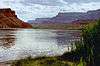
 The Blue River near Kremmling, Colorado. | |
| Country | United States |
|---|---|
| State | Colorado |
| Tributaries | |
| - right | Snake River |
| Source | Tenmile Range |
| - location | Near Blue River, Summit County |
| - elevation | 12,800 ft (3,901 m) |
| - coordinates | 39°23′27″N 106°01′12″W / 39.39083°N 106.02000°W [1] |
| Mouth | Colorado River |
| - location | Kremmling, Grand County |
| - elevation | 7,342 ft (2,238 m) |
| - coordinates | 40°02′33″N 106°23′48″W / 40.04250°N 106.39667°WCoordinates: 40°02′33″N 106°23′48″W / 40.04250°N 106.39667°W [1] |
| Length | 65 mi (105 km) |
| Basin | 680 sq mi (1,761 km2) [2] |
| Discharge | for 0.3 mi (0.48 km) below Green Mountain Dam |
| - average | 447 cu ft/s (13 m3/s) [3] |
| - max | 4,040 cu ft/s (114 m3/s) |
| - min | 0 cu ft/s (0 m3/s) |
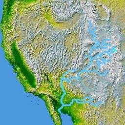 The Blue River, a tributary of the Colorado, is shown highlighted on a map of the western United States
| |
The Blue River is a tributary of the Colorado River, approximately 65 miles (105 km) long,[4] in the U.S. state of Colorado.
It rises in southern Summit County, on the western side of the continental divide in the Ten Mile Range, near Quandary Peak. It flows north past Blue River and Breckenridge, then through the Dillon Reservoir near Dillon. North of Dillon it flows NNW along the eastern slope of the Gore Range and joins the Colorado at Kremmling.
The Green Mountain Dam, 13 miles (21 km) upstream from Kremmling, forms the Green Mountain Reservoir, providing hydroelectric power and diversionary water for irrigation, as part of the Colorado-Big Thompson Project. The dam is a project of the United States Bureau of Reclamation.
See also
References
- 1 2 "Blue River". Geographic Names Information System. United States Geological Survey. Retrieved 2011-01-26.
- ↑ "Blue River Watershed Fast Facts". Blue River Watershed Group. Retrieved 2013-07-16.
- ↑ "USGS Gage #09057500 on the Blue River below Green Mountain Reservoir, Colorado" (PDF). National Water Information System. U.S. Geological Survey. 1943–2012. Retrieved 2013-07-16.
- ↑ U.S. Geological Survey. National Hydrography Dataset high-resolution flowline data. The National Map Archived 2012-04-05 at WebCite, accessed March 18, 2011
External links
Colorado River system | |||||||||||||||
|---|---|---|---|---|---|---|---|---|---|---|---|---|---|---|---|
| Jurisdictions |
|     | |||||||||||||
| Canyons |
| ||||||||||||||
| Natural features |
| ||||||||||||||
| Tributaries | |||||||||||||||
| Engineering |
| ||||||||||||||
| Designated areas | |||||||||||||||
| Related topics | |||||||||||||||
This article is issued from Wikipedia - version of the 11/19/2016. The text is available under the Creative Commons Attribution/Share Alike but additional terms may apply for the media files.