Boonville Township, Cooper County, Missouri
| Boonville Township | |
|---|---|
| Township | |
 Location in Cooper County | |
| Coordinates: 38°57′44″N 92°44′50″W / 38.96222°N 92.74722°WCoordinates: 38°57′44″N 92°44′50″W / 38.96222°N 92.74722°W | |
| Country |
|
| State |
|
| County | Cooper |
| Area | |
| • Total | 53.47 sq mi (138.5 km2) |
| • Land | 51.82 sq mi (134.23 km2) |
| • Water | 1.65 sq mi (4.27 km2) 3.08% |
| Elevation | 748 ft (228 m) |
| Population (2000) | |
| • Total | 9,898 |
| • Density | 191/sq mi (73.7/km2) |
| Time zone | CST (UTC-6) |
| • Summer (DST) | CDT (UTC-5) |
| ZIP code | 65233 |
| GNIS feature ID | 0766527 |
Boonville Township is one of fourteen townships in Cooper County, Missouri, USA. As of the 2000 census, its population was 9,898.[1]
Geography
According to the United States Census Bureau, Boonville Township covers an area of 53.47 square miles (138.5 square kilometers); of this, 51.82 sq mi (134.2 km2, 96.92 percent) is land and 1.65 square miles (4.27 square kilometers, 3.08 percent) is water.
Cities, towns, villages
Unincorporated towns
- Billingsville at 38°54′11″N 92°47′40″W / 38.903081°N 92.794356°W
- Merna at 38°58′16″N 92°38′59″W / 38.971142°N 92.64963°W
(This list is based on USGS data and may include former settlements.)
Adjacent townships
- Franklin Township, Howard County (north)
- Moniteau Township, Howard County (northeast)
- Saline Township (east)
- Clark Fork Township (southeast)
- Palestine Township (southwest)
- Lamine Township (west)
- Pilot Grove Township (west)
- Boonslick Township, Howard County (northwest)
Cemeteries
The township contains Walnut Grove Cemetery.
Major highways
Airports and landing strips
- Jesse Viertel Memorial Airport
Landmarks
- Harley Park
School districts
- Boonville School District
Political districts
- Missouri's 6th congressional district
- State House District 117
- State Senate District 21
References
- United States Census Bureau 2008 TIGER/Line Shapefiles
- United States Board on Geographic Names (GNIS)
- United States National Atlas
External links

Municipalities and communities of Cooper County, Missouri, United States | ||
|---|---|---|
| Cities | 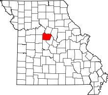 | |
| Villages | ||
| Townships | ||
| Unincorporated communities | ||
This article is issued from Wikipedia - version of the 11/6/2016. The text is available under the Creative Commons Attribution/Share Alike but additional terms may apply for the media files.