Otterville Township, Cooper County, Missouri
| Otterville Township | |
|---|---|
| Township | |
 Location in Cooper County | |
| Coordinates: 38°42′49″N 93°00′48″W / 38.71361°N 93.01333°WCoordinates: 38°42′49″N 93°00′48″W / 38.71361°N 93.01333°W | |
| Country |
|
| State |
|
| County | Cooper |
| Area | |
| • Total | 27.24 sq mi (70.56 km2) |
| • Land | 27.24 sq mi (70.55 km2) |
| • Water | 0.01 sq mi (0.02 km2) 0.03% |
| Elevation | 725 ft (221 m) |
| Population (2000) | |
| • Total | 913 |
| • Density | 33.5/sq mi (12.9/km2) |
| Time zone | CST (UTC-6) |
| • Summer (DST) | CDT (UTC-5) |
| ZIP codes | 65276, 65301, 65348 |
| GNIS feature ID | 0766534 |
Otterville Township is one of fourteen townships in Cooper County, Missouri, USA. As of the 2000 census, its population was 913.[1]
Geography
According to the United States Census Bureau, Otterville Township covers an area of 27.24 square miles (70.56 square kilometers); of this, 27.24 square miles (70.55 square kilometers, 99.99 percent) is land and 0.01 square miles (0.02 square kilometers, 0.03 percent) is water.
Cities, towns, villages
Unincorporated towns
(This list is based on USGS data and may include former settlements.)
Adjacent townships
- Clear Creek Township (north)
- Lebanon Township (east)
- Richland Township, Morgan County (south)
- Smithton Township, Pettis County (southwest)
- Bowling Green Township, Pettis County (west)
- Heath Creek Township, Pettis County (northwest)
Cemeteries
The township contains these two cemeteries: Saint Josephs and Shackleford.
Major highways
School districts
- Otterville R-Vi
- Pilot Grove C-4
- Smithton R-Vi
Political districts
- Missouri's 6th congressional district
- State House District 117
- State House District 118
- State Senate District 21
- State Senate District 28
References
- United States Census Bureau 2008 TIGER/Line Shapefiles
- United States Board on Geographic Names (GNIS)
- United States National Atlas
External links
 |
Heath Creek Township, Pettis County | Clear Creek Township | | |
| Bowling Green Township, Pettis County | |
Lebanon Township | ||
| ||||
| | ||||
| Smithton Township, Pettis County | Richland Township, Morgan County |
Municipalities and communities of Cooper County, Missouri, United States | ||
|---|---|---|
| Cities | 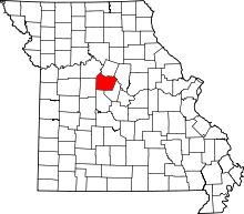 | |
| Villages | ||
| Townships | ||
| Unincorporated communities | ||
This article is issued from Wikipedia - version of the 6/29/2014. The text is available under the Creative Commons Attribution/Share Alike but additional terms may apply for the media files.