Bournezeau
| Bournezeau | ||
|---|---|---|
|
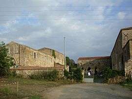
The Abbey of Trizay, in Bournezeau | ||
| ||
 Bournezeau | ||
|
Location within Pays de la Loire region  Bournezeau | ||
| Coordinates: 46°38′11″N 1°10′15″W / 46.6364°N 1.1708°WCoordinates: 46°38′11″N 1°10′15″W / 46.6364°N 1.1708°W | ||
| Country | France | |
| Region | Pays de la Loire | |
| Department | Vendée | |
| Arrondissement | La Roche-sur-Yon | |
| Canton | Chantonnay | |
| Intercommunality | Deux Lays | |
| Government | ||
| • Mayor (2008–2014) | Louis-Marie Giraudeau | |
| Area1 | 60.49 km2 (23.36 sq mi) | |
| Population (2006)2 | 2,933 | |
| • Density | 48/km2 (130/sq mi) | |
| Time zone | CET (UTC+1) | |
| • Summer (DST) | CEST (UTC+2) | |
| INSEE/Postal code | 85034 / 85480 | |
| Elevation | 12–104 m (39–341 ft) | |
|
1 French Land Register data, which excludes lakes, ponds, glaciers > 1 km² (0.386 sq mi or 247 acres) and river estuaries. 2 Population without double counting: residents of multiple communes (e.g., students and military personnel) only counted once. | ||

Bournezeau is a commune in the Vendée department in the Pays de la Loire region in western France.
Geography
The river Lay forms all of the commune's south-eastern border.
See also
References
| Wikimedia Commons has media related to Bournezeau. |
This article is issued from Wikipedia - version of the 9/17/2015. The text is available under the Creative Commons Attribution/Share Alike but additional terms may apply for the media files.