Saint-Prouant
| Saint-Prouant | ||
|---|---|---|
|
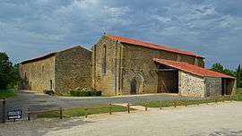
Grammont priory, in Saint-Prouant | ||
| ||
 Saint-Prouant | ||
|
Location within Pays de la Loire region  Saint-Prouant | ||
| Coordinates: 46°45′33″N 0°57′21″W / 46.7592°N 0.9558°WCoordinates: 46°45′33″N 0°57′21″W / 46.7592°N 0.9558°W | ||
| Country | France | |
| Region | Pays de la Loire | |
| Department | Vendée | |
| Arrondissement | La Roche-sur-Yon | |
| Canton | Chantonnay | |
| Intercommunality | Deux Lays | |
| Government | ||
| • Mayor (2014–2020) | Yannick Soulard | |
| Area1 | 12.86 km2 (4.97 sq mi) | |
| Population (2006)2 | 1,409 | |
| • Density | 110/km2 (280/sq mi) | |
| Time zone | CET (UTC+1) | |
| • Summer (DST) | CEST (UTC+2) | |
| INSEE/Postal code | 85266 / 85110 | |
| Elevation | 54–118 m (177–387 ft) | |
|
1 French Land Register data, which excludes lakes, ponds, glaciers > 1 km² (0.386 sq mi or 247 acres) and river estuaries. 2 Population without double counting: residents of multiple communes (e.g., students and military personnel) only counted once. | ||
.svg.png)
Saint-Prouant is a commune in the Vendée department in the Pays de la Loire region in western France.
Geography
The river Lay forms all of the commune's eastern border.
Monuments
- Grammont priory.
See also
References
| Wikimedia Commons has media related to Saint-Prouant. |
This article is issued from Wikipedia - version of the 2/11/2016. The text is available under the Creative Commons Attribution/Share Alike but additional terms may apply for the media files.